Artificial intelligence submarine navigation system
A technology of navigation system and artificial intelligence, applied in the field of submarine navigation system, can solve the problem of inability to observe navigation signs and other problems
- Summary
- Abstract
- Description
- Claims
- Application Information
AI Technical Summary
Problems solved by technology
Method used
Image
Examples
Embodiment 1
[0027] Such as figure 1 As shown, the present invention discloses an artificial intelligence submarine navigation system, including a serial port communication module, a filtering algorithm module and a network communication module, the serial port communication module realizes serial port communication through a serial port driver, and the filtering algorithm module passes through the collection Filter the sensor data to obtain high-precision position, attitude, speed, heading and height from the bottom. The network communication module is used to use the navigation system as a client and the underwater master control system as a server. Next, complete the function of real-time listening to server query information and sending navigation information to the server.
Embodiment 2
[0029] Such as figure 2As shown, the serial port communication module: this module mainly realizes the serial port communication through the serial port driver. This module mainly realizes two functions, namely, the data acquisition function of the sensor and the serial port communication function with the emergency unit. Sensor data acquisition includes RS422 serial communication with PHINS and GPS, RS232 communication with DVL and depth gauge, and RS485 communication with altimeter, and check and unpack the received data to obtain the data required for integrated navigation filter calculation . The serial port communication with the emergency unit only exists under emergency working conditions. At this time, the emergency unit sends query messages to the navigation system through the 485 serial port, and the navigation system sends the navigation information originally sent to the underwater master control to the emergency unit through the serial port.
[0030] Filtering ...
Embodiment 3
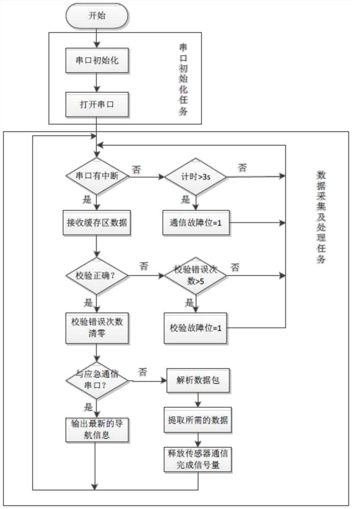
[0033] Specifically, the serial port communication module consists of six modules: PHINS data acquisition module, GPS data acquisition module, DVk data acquisition module, depth gauge data acquisition module, altimeter data acquisition module, and emergency serial port communication module. Each serial port task is initialized by the serial port Task and data acquisition and processing tasks are composed of two parts. In the serial port initialization task, you can set the parameters of the serial port (start bit, data bit, stop bit and baud rate) and the serial port mode (RS232, RS485, RS422). The data acquisition and processing tasks are used to receive the data in the serial port buffer area and process them. The serial port communication of PHINS, DVL, GPS, depth gauge, altimeter and underwater emergency system adopts the interrupt method to receive data. The communication process of each serial port is basically the same, but when communicating with the emergency unit, if...
PUM
 Abstract
Description
Claims
Application Information
 - R&D
- Intellectual Property
- Life Sciences
- Materials
- Tech Scout
- Unparalleled Data Quality
- Higher Quality Content
- 60% Fewer Hallucinations
Browse by: Latest US Patents, China's latest patents, Technical Efficacy Thesaurus, Application Domain, Technology Topic, Popular Technical Reports.
© 2025 PatSnap. All rights reserved.Legal|Privacy policy|Modern Slavery Act Transparency Statement|Sitemap|About US| Contact US: help@patsnap.com


