AutoCAD-based automatic mapping method for adaptive curve trend

An adaptive and curved technology, applied in the field of automatic mapping based on AutoCAD adaptive curve trend, can solve the problems of automatic filling of geological section maps, etc., achieve the effect of filling specifications, uniform filling format, and enhanced filling effect

Active Publication Date: 2022-05-03
CHINA RAILWAY ERYUAN ENG GRP CO LTD
View PDF8 Cites 1 Cited by
  • Summary
  • Abstract
  • Description
  • Claims
  • Application Information

AI Technical Summary

Problems solved by technology

[0005] The purpose of the present invention is to overcome the above-mentioned deficiencies in the prior art that cannot automatically fill geological section maps, and provide a method for automatically filling maps based on AutoCAD adaptive curve trends, which can automatically perform automatic filling according to the curve trends in the AutoCAD figure Fill patterns to realize automatic filling of complex cross-sectional views

Method used


Image

  • AutoCAD-based automatic mapping method for adaptive curve trend
  • AutoCAD-based automatic mapping method for adaptive curve trend
  • AutoCAD-based automatic mapping method for adaptive curve trend

Examples


Embodiment

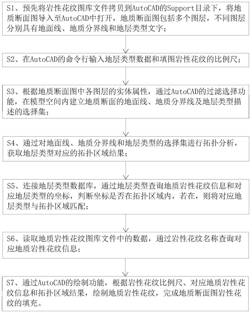
[0049] Please refer to figure 1 , the present embodiment provides a kind of automatic mapping method based on AutoCAD self-adaptive curve trend, comprising the following steps:

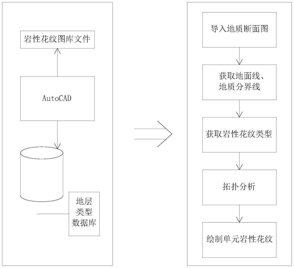
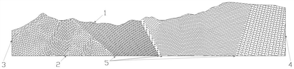
[0050] S1. Copy the lithological pattern library file to the Support directory of AutoCAD in advance, import the geological section map into AutoCAD and open it, and AutoCAD automatically loads the geological section curve. The geological section map includes multiple layers, and each layer has ground line, geological boundary and stratum type text;

[0051] Among them, the lithological pattern gallery includes picture files of lithological patterns of different strata types, which are in the PAT file format, and this file format also includes the unit format filled with lithological patterns, and the unit format is the information parameters contained in each lithological pattern , including the description of the type, line length, direction, coordinate and angle of the basic graphic elements, the ...


PUM


Abstract

The invention discloses an automatic mapping method based on an AutoCAD adaptive curve trend, which is applied to the technical field of geological exploration mapping, and comprises the following steps: S1, copying a lithologic pattern map library file, and importing a geological cross-section diagram into AutoCAD; s2, measuring a plotting scale; s3, establishing a ground line of the geological section, a geological boundary line and a selection set of stratum type description; s4, topological analysis is carried out on the selection set, and a topological region result corresponding to the stratum type is obtained; s5, connecting a stratum type database, and querying coordinates of the geological lithologic pattern information and the stratum type; s6, inquiring lithologic pattern information in the geological lithologic pattern library file; s7, filling of lithologic patterns of the geological cross-section diagram is completed through AutoCAD; according to the method, the complex geological cross-section diagram filling work can be adaptively processed, the workload is greatly reduced, the efficiency of the filling work is improved, filling is more standard and attractive, the filling format is unified, and the filling effect is enhanced.

Description

technical field [0001] The invention relates to the technical field of geological exploration and mapping, in particular to an automatic mapping method based on AutoCAD adaptive curve trend. Background technique [0002] A geological section map is a map showing geological phenomena and their interrelationships on a geological section at a certain scale. The combination of geological section map and geological section map can obtain the three-dimensional concept of geological structure. Geological section map is one of the important geological section maps. It is a cross-sectional map obtained by tangent to the terrain with an imaginary vertical plane along a certain direction on the surface. The intersection line between the section and the ground is called the section line. A geological section map is a map that uses a certain scale to record and reveal the relationship between landforms and internal structures in a section in a certain direction. It can be compiled thr...

Claims


Application Information

Patent Timeline
Patent Type & Authority Applications(China)
IPC IPC(8): G06F30/13G06F111/20
CPCG06F30/13G06F2111/20
Inventor 朱泳标张广泽张雨露李娜邹杨杨科吴彦格陈兵黄弘肖红玉
Owner CHINA RAILWAY ERYUAN ENG GRP CO LTD
Why Eureka
Try Eureka