Auxiliary surveying and mapping device for landscape garden model design

A technology of model design and surveying and mapping device, applied in the field of garden art, to achieve the effect of improving accuracy and practicality

Pending Publication Date: 2022-05-06
XUZHOU UNIV OF TECH
View PDF0 Cites 1 Cited by
  • Summary
  • Abstract
  • Description
  • Claims
  • Application Information

AI Technical Summary

Problems solved by technology

[0004] The main purpose of the present invention is to provide a landscape garden model design auxiliary surveying and mapping device, to solve the current problems

Method used


Image

  • Auxiliary surveying and mapping device for landscape garden model design
  • Auxiliary surveying and mapping device for landscape garden model design
  • Auxiliary surveying and mapping device for landscape garden model design

Examples


Embodiment 1

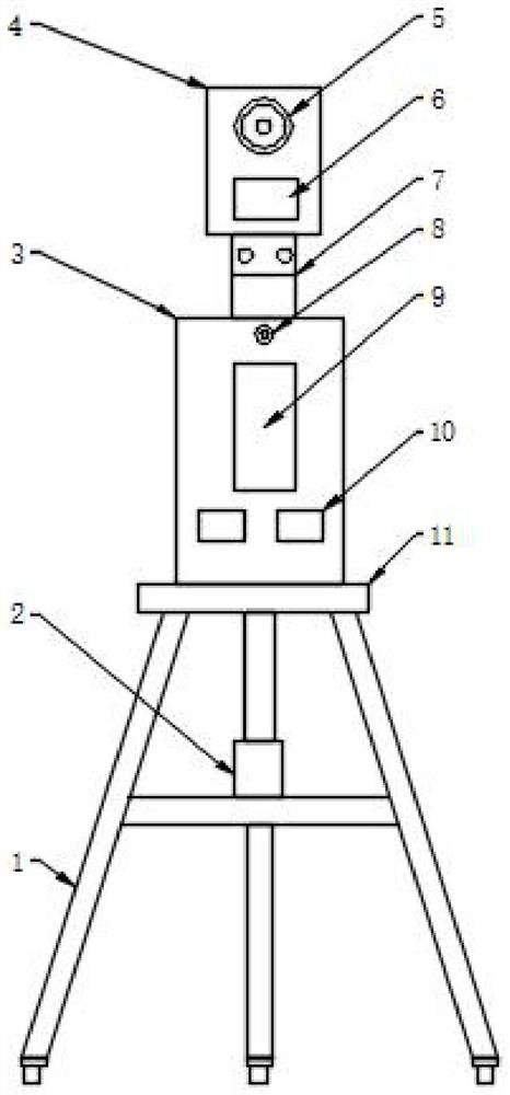
[0060] A landscape garden model design auxiliary surveying and mapping device, comprising:

[0061] The supporting component is used to install the control system and the surveying and mapping system; the supporting component can be disassembled, which is convenient for transportation to the construction site for assembly. After assembly, the surveying and mapping equipment and control equipment are installed.

[0062]The surveying and mapping system is set on the supporting component, and is used to obtain the survey data information of the landscape garden and send it to the control system; the surveying and mapping system scans and surveys the landscape garden area on the spot to obtain three-dimensional image data of the geographical features, and collects After the data is collected, a more intuitive topographic map can be obtained through three-dimensional data modeling. Based on this, the landscape model design can be done to improve the accuracy and practicality of the ...

Embodiment approach

[0094] In order to install the surveying and mapping system, as an optional embodiment of the present invention, optionally, also include:

[0095] A connection hole is provided on the control box 3;

[0096] The telescopic adjusting rod 7 is connected between the control box 3 and the infrared camera 4; its bottom is fixed on the top of the control box 3 by a bolt assembly.

[0097] The surveying and mapping system is fixed on the top of the control box 3 through the telescopic adjustment rod 7, specifically a threaded hole is installed on the top of the control box 3, and the bottom of the telescopic adjustment rod 7 is fixed on the top of the control box 3 by a bolt assembly. The telescopic adjusting rod 7 can adjust the height.

[0098] As an optional implementation of the present invention, optionally, the telescopic adjusting rod includes:

[0099] The first expansion joint is connected to the bottom of the infrared camera device 4;

[0100] The second expansion joint...

Embodiment 2

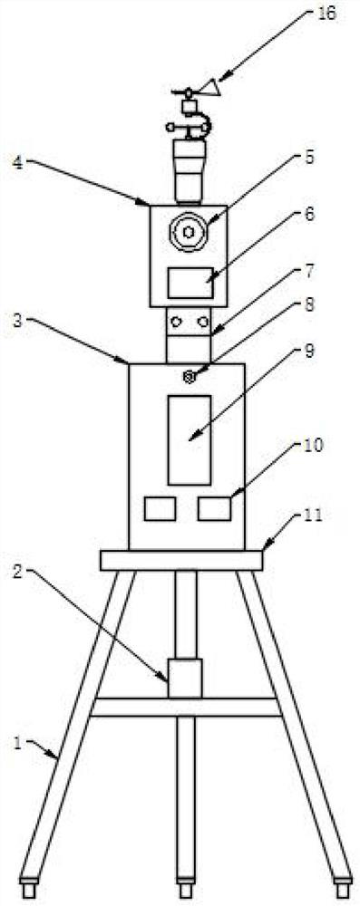
[0107] On the basis of Embodiment 1, this embodiment adds a set of wind speed measurement system 16, which is used to provide the wind direction and wind speed surveying and mapping function of the park for the model design of the landscape garden, and provides the parameters of wind speed and wind direction for the design of the landscape garden model , which is convenient for assisting model design, taking into account the wind factor, improving the accuracy of the geographic model for model design, and improving the contrast between the model and the field.

[0108] Such as image 3 and Figure 4 As shown, as an optional implementation of the present invention, optionally, the surveying and mapping system also includes:

[0109] The wind speed measuring system 16 is arranged on the support assembly, and is used for measuring the wind speed of the landscape garden and sending the wind speed information to the control system.

[0110] As an optional implementation of the pr...


PUM


Abstract

The invention discloses an auxiliary surveying and mapping device for landscape garden model design, and the device comprises a supporting assembly which is used for installing a control system and a surveying and mapping system; the surveying and mapping system is arranged on the supporting assembly and is used for acquiring landscape garden practical exploration data information and sending the landscape garden practical exploration data information to the control system; the control system is arranged on the supporting assembly and used for receiving and controlling the surveying and mapping system and storing surveying and mapping data information; the power supply system is arranged on the supporting assembly and used for supplying power to the surveying and mapping system and the control system; the surveying and mapping system and the control system are respectively in power supply connection with the power supply system, and the surveying and mapping system is in communication connection with the control system. According to the landscape garden model design method, field scanning surveying and mapping can be carried out on a landscape garden region through the surveying and mapping system to obtain three-dimensional image data of geographic landforms, after the data are collected, three-dimensional data modeling is carried out, a more visual landform map can be obtained, landscape garden model design is carried out on the basis, and the accuracy and the practical operability of model design are conveniently improved.

Description

technical field [0001] The invention relates to the technical field of garden art, in particular to an auxiliary surveying and mapping device for landscape garden model design. Background technique [0002] During the planning and design of landscape gardens, designers are required to conduct on-site surveys of the planned area of ​​the landscape park, so as to facilitate the matching design of the planning schematic diagram of the scenic spot after understanding the on-site geographic information and the surrounding environment, and establish a three-dimensional model of the landscape garden for subsequent construction. refer to. [0003] In traditional park surveying and mapping, project personnel and designers, etc., carry out modeling and design after taking photos and measuring distances on the spot, and having a general understanding of the planned area. It lacks real and effective geographic information data, such as geographic topography, dynamic panorama terrain im...

Claims


Application Information

Patent Timeline
IPC IPC(8): G01C15/00G01D11/30
CPCG01C15/00G01D11/30
Inventor 谭雪红李星慧彭赟乐
Owner XUZHOU UNIV OF TECH
Why Eureka
Try Eureka