Satellite-borne multichannel GNSS-S radar video imaging system and ship trajectory extraction method

An imaging system and multi-channel technology, applied in the field of spaceborne multi-channel GNSS-S radar video imaging system and ship trajectory extraction, can solve the problems of only ten meters, limited effective bandwidth of navigation satellite signals, etc.

Active Publication Date: 2022-05-13
BEIJING SATELLITE INFORMATION ENG RES INST
View PDF4 Cites 3 Cited by
  • Summary
  • Abstract
  • Description
  • Claims
  • Application Information

AI Technical Summary

Problems solved by technology

At the same time, some other technologies propose to use the scattered signals of navigation satellite signals (GNSS-S) on the ground to realize dual-station SAR imaging, but limited by the effective bandwidth of navigation satellite signals, the corresponding imaging resolution is generally only in the ten meter class

Method used


Image

  • Satellite-borne multichannel GNSS-S radar video imaging system and ship trajectory extraction method
  • Satellite-borne multichannel GNSS-S radar video imaging system and ship trajectory extraction method
  • Satellite-borne multichannel GNSS-S radar video imaging system and ship trajectory extraction method

Examples


Embodiment Construction

[0067] In order to more clearly describe the embodiments of the present invention or the technical solutions in the prior art, the following will briefly introduce the drawings that are used in the embodiments. Apparently, the drawings in the following description are only some embodiments of the present invention, and those skilled in the art can also obtain other drawings according to these drawings without creative efforts.

[0068] The present invention will be described in detail below in conjunction with the accompanying drawings and specific embodiments, and the embodiments cannot be repeated here one by one, but the embodiments of the present invention are not therefore limited to the following embodiments.

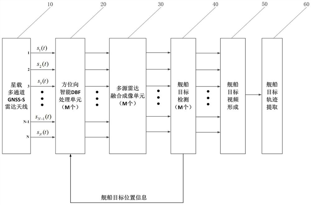
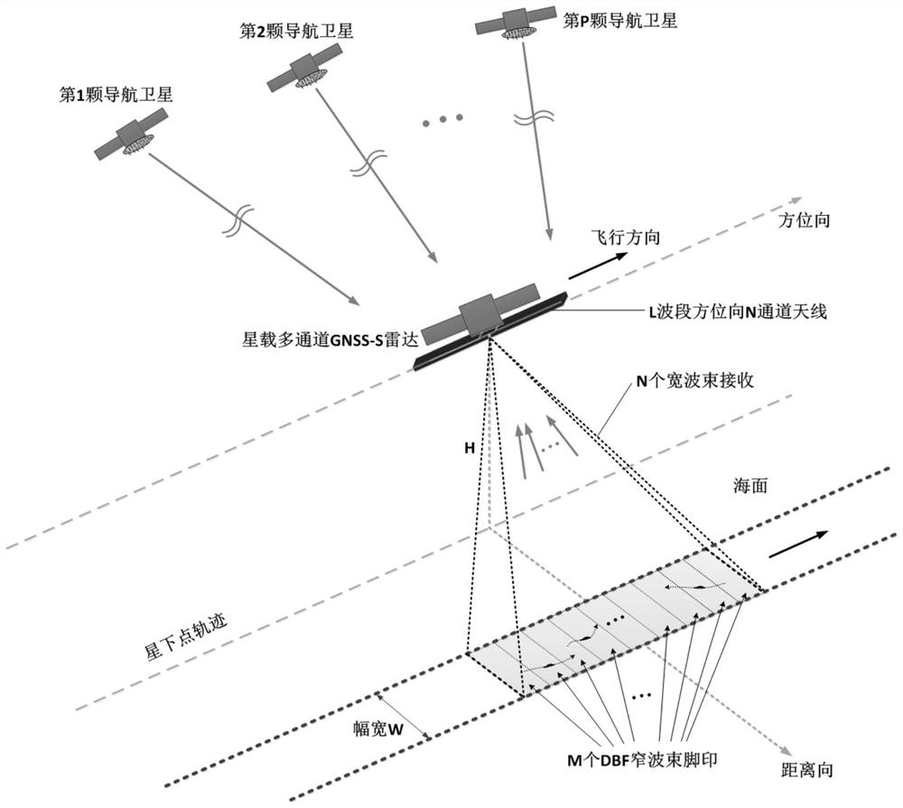
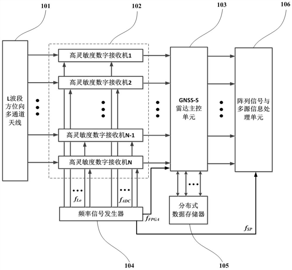
[0069] see figure 1 , the space-borne multi-channel GNSS-S radar video imaging system of the present invention is suitable for high-resolution wide-range SAR imaging, and can be applied to key technology research of space-based distributed high-resolution wide-range...


PUM


Abstract

The invention relates to a satellite-borne multichannel GNSS-S radar video imaging system and a ship trajectory extraction method, and the system comprises a satellite-borne multichannel GNSS-S radar (10) which is used for synchronously receiving echo signals of a sea surface ship target; the azimuth intelligent DBF processing unit (20) is used for processing the echo signal to form a two-dimensional echo signal; the multi-source radar fusion imaging unit (30) is used for processing the navigation satellite scattering signal to obtain a radar image with a high signal-clutter-noise ratio; the ship target detection unit (40) is used for carrying out ship target detection and positioning on the radar image with the high signal-clutter-noise ratio and extracting slice information of a ship target; the ship target video forming unit (50) is used for forming a video image of the ship target; and the ship target track extraction unit (60) is used for forming a motion track of the ship target. The method has the advantages of long-time video imaging, batch ship target trajectory extraction, high concealment, low system power consumption and the like.

Description

technical field [0001] The invention relates to a spaceborne multi-channel GNSS-S radar video imaging system and a ship trajectory extraction method. Background technique [0002] Sea surface ship target detection and video imaging have always been hot spots in scientific research, but affected by weather such as clouds, rain and fog at sea, it is difficult for optical sensors to take advantage of their high-resolution imaging and recognition advantages. The space-borne SAR system can penetrate clouds and fog, and can realize all-weather and all-weather observation of the sea. It is suitable for high-resolution imaging and detection applications of sea surface ship targets. Long-term video imaging and motion trajectory extraction. Since GNSS-S does not need to actively transmit signals when using GNSS-S to detect ships on the sea surface, it only needs to receive the scattered signals of navigation satellite signals to achieve target detection, so it has the advantage of lo...

Claims


Application Information

Patent Timeline
Patent Type & Authority Applications(China)
IPC IPC(8): G01S13/88G01S13/90G01S19/14G01S19/37
CPCG01S13/88G01S13/9004G01S13/9021G01S19/14G01S19/37
Inventor 夏正欢岳富占赵志龙金世超张庆君王海涛彭涛董启甲张瑶刘新尹心高文宁
Owner BEIJING SATELLITE INFORMATION ENG RES INST
Why Eureka
Try Eureka