Supercharge Your Innovation With Domain-Expert AI Agents!

Unmanned aerial vehicle aerial image and satellite image matching method

A satellite image and aerial image technology, applied in the field of image processing, can solve the problems of low matching accuracy, large differences in image scale and features, etc.

Pending Publication Date: 2022-05-27
HARBIN INST OF TECH
View PDF0 Cites 2 Cited by
  • Summary
  • Abstract
  • Description
  • Claims
  • Application Information

AI Technical Summary

Problems solved by technology

[0004] The purpose of the present invention is to solve the problem that the existing method of matching UAV aerial images with satellite images has great differences in scale and features between images, resulting in low matching accuracy, and proposes a UAV aerial image and satellite image Satellite image matching method

Method used


Image

  • Unmanned aerial vehicle aerial image and satellite image matching method
  • Unmanned aerial vehicle aerial image and satellite image matching method
  • Unmanned aerial vehicle aerial image and satellite image matching method

Examples


specific Embodiment approach 1

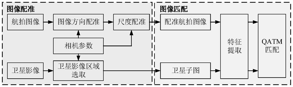
[0024] Embodiment 1: The specific process of a method for matching an aerial photographic image of an unmanned aerial vehicle with a satellite image in this embodiment is as follows:

[0025] The present invention mainly studies a method for realizing the matching between the aerial photography image of the UAV and the satellite image. Because UAV aerial images are usually high-precision, small-scale images with a small coverage area taken at low flight altitudes, while satellite images are scanned and imaged by satellites, which are large-scale images with wide coverage. The existing image matching technology It cannot adapt to the matching between images with too large scale differences, so the present invention proposes a method to realize image registration by using camera imaging pose parameters according to the characteristics between UAV aerial photography images and satellite images, and then through QATM ( Quality-Aware TemplateMatching For Deep Learning) matching alg...

specific Embodiment approach 2

[0036] Embodiment 2: The difference between this embodiment and Embodiment 1 is that in the step 1, the satellite image and the UAV aerial image are obtained, and the direction registration is performed on the UAV aerial image based on the satellite image; the specific process is:

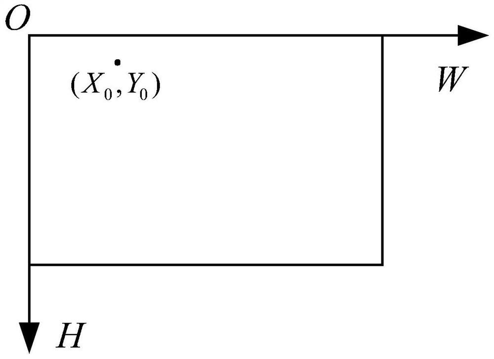
[0037] Take the upper left corner of the image as the origin O to establish the pixel coordinate system HOW, H is the ordinate of the pixel coordinate system, which is the height of the image; W is the abscissa of the pixel coordinate system, which is the width of the image;

[0038] A point in the image pixel coordinate system (X 0 ,Y 0 ) coordinates (X′ after rotating θ degrees clockwise around the center of the image 0 ,Y′ 0 ) is calculated by:

[0039]

[0040] The theoretical basis for formula (1) is as follows:

[0041] In the present invention, the direction registration of the image is realized by rotating the image. The essence of the image rotation is the rotation change of the coo...

specific Embodiment approach 3

[0055] Embodiment 3: The difference between this embodiment and Embodiment 1 or 2 is that in the step 2, scale space registration is performed on the UAV aerial image and satellite image after direction registration, and after scale space registration is obtained The UAV aerial imagery; the specific process is:

[0056] In the present invention, the registration of the UAV aerial image and the satellite image scale space is realized by calculating the scale relationship between the aerial image and the satellite image, and then resampling the aerial image to adjust the image pixel size according to the scale relationship.

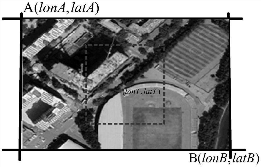
[0057] Assume that the length of the currently selected satellite image ground coverage area is L aX , the width is L aY , the satellite image size is H a ×W a , H a is the number of pixels in the satellite image image line, W a is the number of pixels in the satellite image image column;

[0058] Correspondingly, the size of the UAV aerial image is h...


PUM


Abstract

The invention relates to an unmanned aerial vehicle aerial image and satellite image matching method, in particular to an unmanned aerial vehicle aerial image and satellite image matching method. The objective of the invention is to solve the problem of low matching accuracy caused by great difference of scales and features between images when an unmanned aerial vehicle aerial image is matched with a satellite image in the prior art. The method comprises the following steps: 1, performing direction registration on an aerial image of an unmanned aerial vehicle based on a satellite image; 2, obtaining an unmanned aerial vehicle aerial image after scale space registration; 3, acquiring sub-images of the satellite image; 4, acquiring a trained feature extraction network; 5, extracting the feature vector of the aerial image and the feature vector of the sub-image of the satellite image; and calculating feature response scores of the feature vectors of the aerial image and the feature vectors of the sub-images of the satellite image, and selecting an area with the highest score as an optimal matching result, thereby realizing matching of the aerial image of the unmanned aerial vehicle and the satellite image. The method is applied to the field of image processing.

Description

technical field [0001] The invention belongs to the field of image processing, and relates to a method for realizing the matching of the aerial photography image of the unmanned aerial vehicle with the satellite image by utilizing the aerial photography camera pose parameters of the unmanned aerial vehicle, the longitude and latitude information of the satellite image, the feature extraction of deep learning, digital image processing and the like. Background technique [0002] Image matching is a basic task in computer vision and image processing. Through image matching technology, the same position point in space in two or more images can be matched with each other on each image pixel to realize the registration of image coordinate space. Therefore, image matching technology is usually used in image splicing to achieve the coordinate position registration of adjacent images to be spliced. In addition, image matching technology is also used in target tracking, computer vision...

Claims


Application Information

Patent Timeline
Patent Type & Authority Applications(China)
IPC IPC(8): G06V10/74G06K9/62
CPCG06F18/22
Inventor 马琳温育杜陈舒怡何晨光叶亮韩帅孟维晓
Owner HARBIN INST OF TECH
Features
  • R&D
  • Intellectual Property
  • Life Sciences
  • Materials
  • Tech Scout
  • Unparalleled Data Quality
  • Higher Quality Content
  • 60% Fewer Hallucinations
Learn More