
Map drawing system and drawing method

A map drawing and image technology, applied in the field of image processing, can solve the problems of large manpower input, high production cost, and long production cycle, and achieve the effects of saving production costs, avoiding high labor costs, and avoiding high production costs

Pending Publication Date: 2022-06-03
BEIJING ITARGE TECH CO LTD
View PDF0 Cites 0 Cited by
  • Summary
  • Abstract
  • Description
  • Claims
  • Application Information

AI Technical Summary

Problems solved by technology

[0003] The currently used high-precision map collection system mainly relies on manual video recording, recording of GPS information, and recording of collected lidar scanning information. In addition, the measurement data for intersections also requires the participation of total stations, and the above-mentioned high-precision map Drawing also depends on satellite remote sensing data. After obtaining the above data, a large number of people need to use CAD and other auxiliary software to manually draw the above-mentioned high-precision map to obtain the above-mentioned high-precision map. After the fine map is drawn, repeated verification is required, and even repeated verification may cause problems

Method used


Image

  • Map drawing system and drawing method
  • Map drawing system and drawing method
  • Map drawing system and drawing method

Examples


Embodiment Construction

[0028] The embodiments of the present invention will be described in detail below with reference to the accompanying drawings.

[0029] It should be understood that the described embodiments are only some, but not all, embodiments of the present invention. Based on the embodiments of the present invention, all other embodiments obtained by those of ordinary skill in the art without creative efforts shall fall within the protection scope of the present invention.

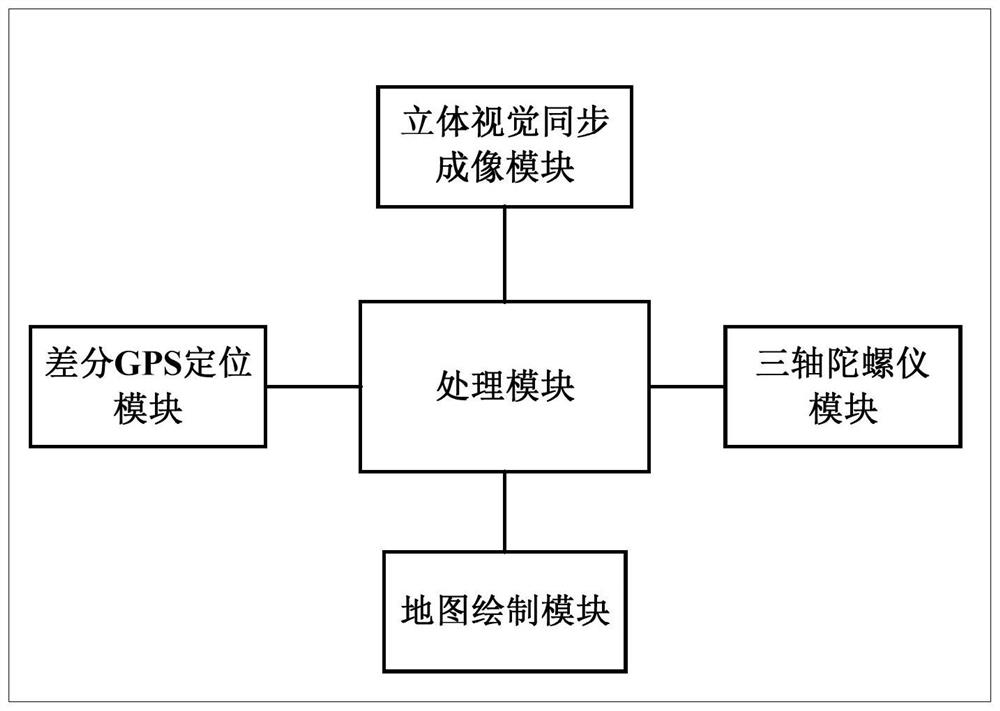
[0030] Attached below figure 1 , the solution provided by the embodiment of the present invention is described in detail, figure 1 It is a system architecture diagram of a map drawing system provided by an embodiment of the present invention. The map drawing system includes a processing module, a stereoscopic synchronous imaging module, a differential GPS positioning module, a three-axis gyroscope module, and a map drawing module. The visual synchronization imaging module, the differential GPS positioning module, t...


PUM


Abstract

The invention discloses a map drawing system and method, and relates to the field of image processing. The method comprises the steps that a road image of a road at the current moment is collected in the vehicle driving process; determining latitude and longitude information and altitude information at the current moment; determining gradient information and radian information of the road at the current moment by utilizing the detected motion state of the three-axis gyroscope; identifying the road image, and determining pixel information of an object included in the road image; carrying out fusion processing according to the pixel information, the latitude and longitude information, the altitude information, the gradient information and the radian information of the object, and generating three-dimensional information of the road at the current moment; and drawing a map according to the three-dimensional information of the road collected at each moment. Therefore, the map can be automatically generated without manual participation, and the labor cost and the manufacturing cost are greatly reduced.

Description

technical field [0001] The invention relates to the field of image processing, in particular to a map drawing system and a drawing method. Background technique [0002] With the rapid development of the assisted driving and autonomous driving industries, the assisted and autonomous driving industries have higher and higher requirements for map accuracy. However, the accuracy of ordinary maps is only about 5 meters. Therefore, the accuracy and information volume of high-precision map information are Guarantee for the development of the autonomous driving industry. [0003] The currently used high-precision map acquisition system mainly relies on manual collection of video recordings, recording of GPS information, and recording of collected lidar scanning information. In addition, the measurement data for intersections also requires the participation of a total station, and the above-mentioned high-precision map Drawing also relies on satellite remote sensing data. After obta...

Claims


Application Information

Patent Timeline
IPC IPC(8): G06T17/00G01C21/00
CPCG06T17/00G01C21/3815
Inventor 杨云飞
Owner BEIJING ITARGE TECH CO LTD
Learn More