Large-scale scene mapping method based on real-time terrain-imitated flight method of unmanned aerial vehicle

A drone and large-scene technology, which is applied in the field of large-scene mapping, can solve the problems that drones cannot change terrain in real time, high-precision laser radar is heavy, and is fixed on the bottom of drones, etc., to achieve light weight, The effect of rich picture information and less number of flights

Pending Publication Date: 2022-06-24
NORTHWESTERN POLYTECHNICAL UNIV
View PDF0 Cites 0 Cited by
  • Summary
  • Abstract
  • Description
  • Claims
  • Application Information

AI Technical Summary

Problems solved by technology

The main disadvantage of these algorithms is that the UAV cannot respond to terrain changes in real time, or it needs to map the area of ​​interest first, then generate the terrain model offline, and then perform secondary planning according to the generated model to achieve the UAV terrain imitation. The purpose of flying; there are also some real-time imitation ground flight methods for drones using lidar, but the disadvantage is that the lidar is fixed at the bottom of the drone, and the high-precision lidar is heavy, which will increase the size of the drone. Energy consumption is also difficult to follow-up control, so when the drone tilts forward during flight, the lidar obtains the distance information behind the drone

Method used


Image

  • Large-scale scene mapping method based on real-time terrain-imitated flight method of unmanned aerial vehicle
  • Large-scale scene mapping method based on real-time terrain-imitated flight method of unmanned aerial vehicle
  • Large-scale scene mapping method based on real-time terrain-imitated flight method of unmanned aerial vehicle

Examples


Embodiment Construction

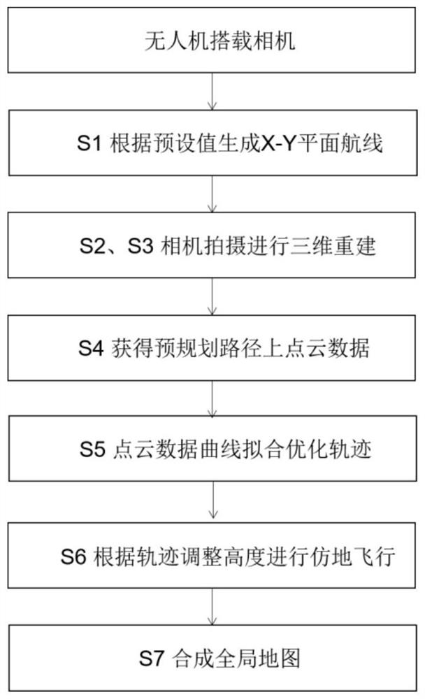
[0043] The content of the present invention is described in further detail below in conjunction with the accompanying drawings and specific embodiments:

[0044] A large scene mapping method based on the real-time ground imitation flight method of UAV, the specific method is as follows:

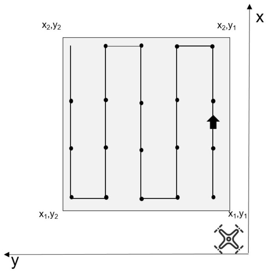
[0045] S1. Make X-Y route planning for the area of ​​interest, take the direction of the nose as the X direction, the top of the drone as the Z direction, and the left side of the drone as the Y direction, and set the four vertices ( x1, y1), (x2, y1), (x2, y2), (x1, y2) are sent to the computing unit, and the nearest point is taken as the take-off point (x1, y1). like figure 2 As shown, the gray part is the region of interest.

[0046] According to the GSD and the overlap ratio required by the flight task, calculate the expected flying height of the UAV relative to the ground, the distance between adjacent shooting points in the X direction of the heading, and the distance between the rou...


PUM


Abstract

The invention provides a large-scene mapping method based on an unmanned aerial vehicle real-time terrain-imitating flight method, which comprises the following steps: firstly, selecting a region of interest for route planning, secondly, when the unmanned aerial vehicle flies to a shooting point, shooting a region below the unmanned aerial vehicle in real time, and obtaining ground sparse point clouds and dense point clouds of a camera shooting region below the unmanned aerial vehicle in real time; calculating the vertical distance between each path point position of the unmanned aerial vehicle in the next flight area in the flight route and the ground in real time by using the sparse point cloud, and generating a ground-imitated flight path of the unmanned aerial vehicle in real time; and the unmanned aerial vehicle flies in a simulated manner according to the generated path, the dense point clouds are spliced according to the poses between adjacent frames until the flight task is executed, and a global map based on the dense point clouds is obtained. The method can be suitable for various complex terrain conditions, real-time ground-imitating flight can still be well carried out under the complex terrain, a data set with a better effect can be obtained while ground-imitating flight is carried out, and real-time dense three-dimensional reconstruction is carried out on a ground-imitating flight area.

Description

technical field [0001] The invention belongs to the technical field of unmanned aerial vehicle map construction, and in particular relates to a large scene mapping method based on a real-time ground imitation flight method of an unmanned aerial vehicle. Background technique [0002] In some industries, such as agriculture, disaster monitoring, urban planning, etc., a quick overview of a designated area has become an increasing demand, so a faster and more accurate way to complete the 3D reconstruction of the area of ​​interest is required. Route planning is the first step in aerial photogrammetry, and determining a suitable flight route is critical to the successful and efficient completion of the mission, as different combinations of flight parameters can affect the flight workload. For areas with flat terrain, using the traditional method of fixed camera exposure baseline, fixed route spacing and fixed flight altitude, it is possible to easily plan routes and obtain models...

Claims


Application Information

Patent Timeline
Patent Type & Authority Applications(China)
IPC IPC(8): G06T17/00G06T15/00
CPCG06T17/00G06T15/005
Inventor 布树辉夏震宇陈霖赵勇韩鹏程李霓
Owner NORTHWESTERN POLYTECHNICAL UNIV
Why Eureka
Try Eureka