Emergency flow measuring instrument for realizing river flow velocity measurement by using satellite positioning technology

A technology of satellite positioning and flow velocity measurement, which is applied in the field of emergency flow meters, can solve problems such as design, movement deviation between buoys and water bodies, flow velocity deviation, etc., and achieve the effect of simple deployment, ensuring safety, and eliminating errors

Pending Publication Date: 2022-06-28
北京益邦达科技发展有限公司 +1
View PDF0 Cites 0 Cited by
  • Summary
  • Abstract
  • Description
  • Claims
  • Application Information

AI Technical Summary

Problems solved by technology

[0006] (1) In the shape design of the buoy, it is not designed according to the characteristics of the river water body, which causes the deviation between the buoy and the movement of the water body;
[0007] (2) In terms of waterproof design, if the waterproof level is not enough, there may be water leakage and water seepage, which will damage the electronic equipment inside the buoy;
[0008] (3) When the buoy is floating in the river, due to the positioning deviation of the satellite positioning and the disturbance of the water body, the direct calculation will bring the deviation of the flow velocity. Currently, there is no system to deal with it

Method used


Image

  • Emergency flow measuring instrument for realizing river flow velocity measurement by using satellite positioning technology
  • Emergency flow measuring instrument for realizing river flow velocity measurement by using satellite positioning technology
  • Emergency flow measuring instrument for realizing river flow velocity measurement by using satellite positioning technology

Examples


Embodiment 1

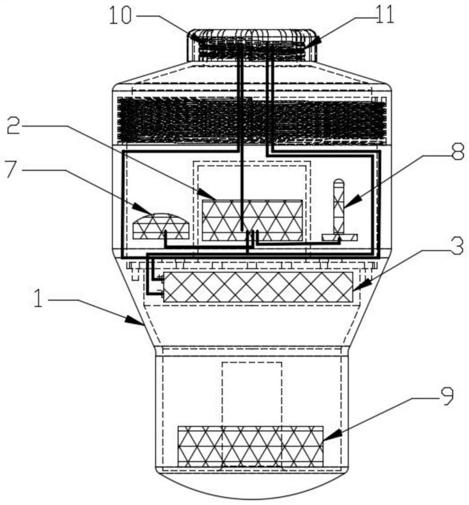
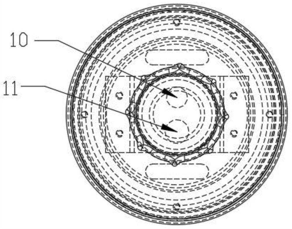
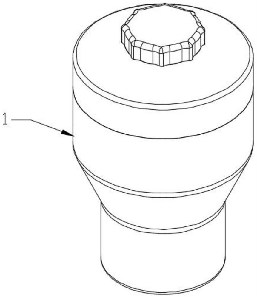
[0041] Example 1: see Figure 1-5, the present invention provides a technical solution: an emergency flow meter for realizing river flow velocity measurement using satellite positioning technology, comprising a casing 1, the casing 1 is built with a high-precision satellite positioning module and a 4G real-time communication module. The core module 2, the housing 1 is also provided with a power supply 3, a power indicator light 4, and a communication signal indicator light 5, a positioning signal indicator light 6, a positioning signal antenna 7 and a positioning signal indicator light 5 respectively connected to the satellite positioning module and the 4G real-time communication module. The communication antenna 8, the bottom of the casing 1 is provided with a counterweight 9, and the top of the casing 1 is provided with a power switch 10 and a charging port 11; a plurality of the emergency current measuring instruments are connected to the monitoring system 12, and a pluralit...

Embodiment 2

[0044] Example 2: see Image 6 , the specific measurement method is: put the emergency flow meter in the river and travel along the river, the satellite positioning module and 4G real-time communication module in the emergency flow meter collect the position point data of the emergency flow meter every 1 second, and send To the monitoring system 12, after the monitoring system 12 receives the data, it filters the data to remove invalid data points, then calculates the flow rate and flow direction according to the water flow characteristic algorithm, and displays the calculated results on the monitoring software; specifically:

[0045] The specific algorithm for removing invalid data points is as follows:

[0046] S1. First collect 10 data points, filter the received data point by point, and then perform basic filtering, and judge the motion state, including the static state and the motion state;

[0047] S2. If it is in a stationary state, use an electronic fence; if it is in...


PUM


Abstract

The invention belongs to the technical field of electronics and information, and particularly discloses an emergency flow measuring instrument for realizing river flow velocity measurement by using a satellite positioning technology, which comprises a shell, and a core module consisting of a high-precision satellite positioning module and a 4G real-time communication module is arranged in the shell; the emergency flow measuring instruments are in data transmission connection with the monitoring system through the 4G real-time communication module, and the monitoring system comprises monitoring software which is used for displaying the drifting track, time, position, flow velocity and flow direction data of the floating ball in real time; the satellite positioning module and the 4G real-time communication module of the flow measurement buoy collect position point data of the flow measurement buoy once every one second, after the monitoring system receives the data, the data are filtered, invalid data points are removed, then the flow velocity and the flow direction are calculated according to a water flow characteristic algorithm, and the calculated result is displayed on monitoring software. And the accuracy of the obtained flow velocity and flow direction data is higher by using the optimal calculation algorithm of the flow velocity.

Description

technical field [0001] The invention relates to the fields of electronics and information technology, and further relates to the field of hydrology measurement, in particular to an emergency flow meter for realizing river flow velocity measurement by utilizing satellite positioning technology. Background technique [0002] At present, the measurement methods of flow velocity in hydrology mainly include buoy method and flow meter method. [0003] The buoy method is an easy way to roughly measure flow velocity. When measuring by the traditional buoy method, take a relatively regular section of the river bed with a length of not less than 10m, no bending, and a certain liquid surface height, measure its average width and water surface height, take a floating object, and put it in the center of the upper reaches of the flowing river. Under the influence of external force (such as wind, blockage of floating objects, etc.), the floating flow is allowed to flow through the measure...

Claims


Application Information

Patent Timeline
Patent Type & Authority Applications(China)
IPC IPC(8): G01P5/18G01P13/02G01S19/39G01S19/42G08C17/02
CPCG01P5/18G01P13/02G01S19/393G01S19/42G08C17/02
Inventor 金云杰刘宝家顾彬倪洋王世界关明皓李锴锋郭松王家智孙忠伦刘长君林树刚马兴涛王琦蔡雨寒
Owner 北京益邦达科技发展有限公司
Why Eureka
Try Eureka