
Digital elevation anomaly data conversion method and device

A technology of abnormal data and digital elevation, applied in image data processing, instrumentation, calculation, etc., can solve problems such as insufficiency, and achieve the effect of large range and high precision

Pending Publication Date: 2022-07-19
NAT GEOMATICS CENT OF CHINA
View PDF0 Cites 0 Cited by
  • Summary
  • Abstract
  • Description
  • Claims
  • Application Information

AI Technical Summary

Problems solved by technology

However, as the management of natural resources and the protection of the ecological environment become increasingly refined, there is a large gap in the level of refinement and changes in the existing data. Demand for more refined digital terrain data in management operations such as regulation and natural resource asset assessment

Method used


Image

  • Digital elevation anomaly data conversion method and device
  • Digital elevation anomaly data conversion method and device
  • Digital elevation anomaly data conversion method and device

Examples


Embodiment Construction

[0037] In order to make the objectives, technical solutions and advantages of the present invention clearer, the present invention will be further described in detail below with reference to the specific embodiments and the accompanying drawings. It should be understood that these descriptions are exemplary only and are not intended to limit the scope of the invention. Also, in the following description, descriptions of well-known structures and techniques are omitted to avoid unnecessarily obscuring the concepts of the present invention.

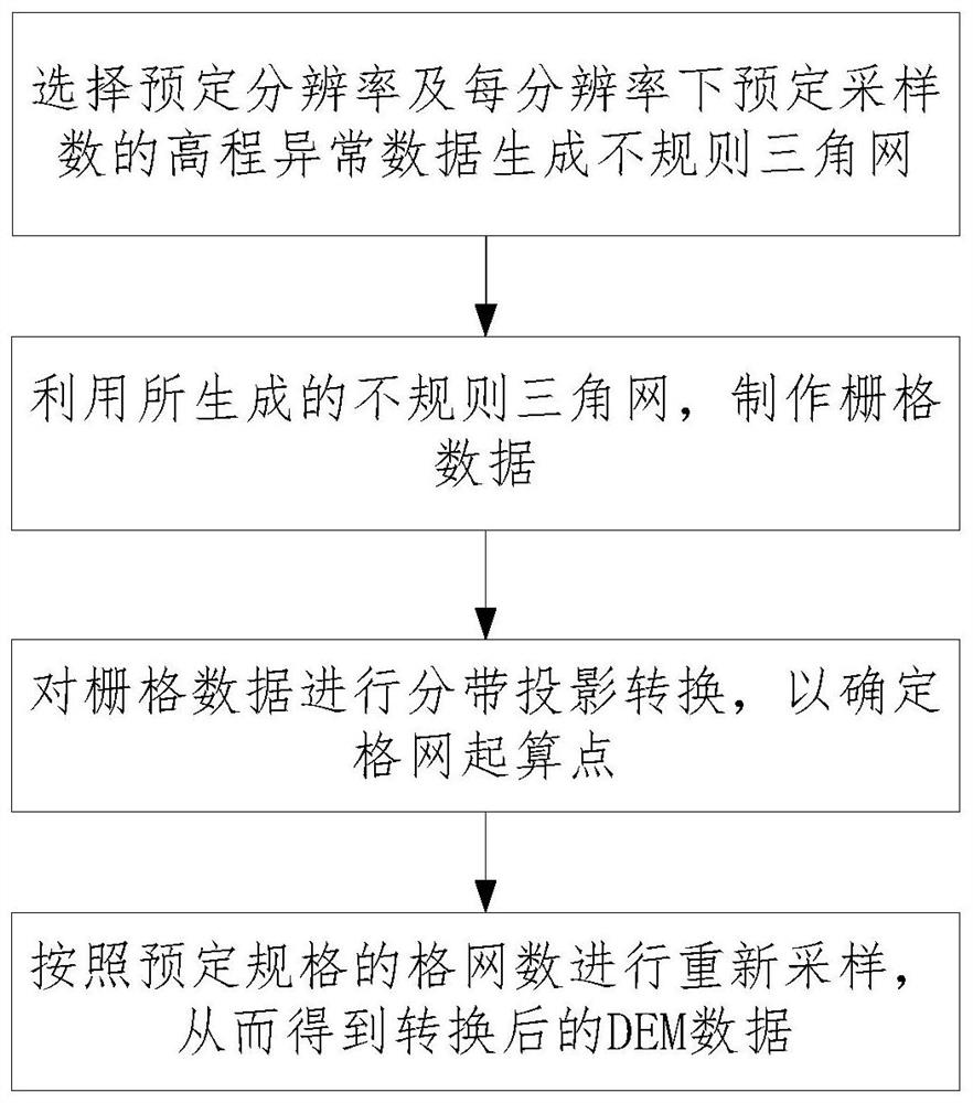
[0038] The technical solutions of the present invention will be described in detail below with reference to the accompanying drawings. According to an embodiment of the present invention, a method for converting digital elevation anomaly data is provided, and the flow chart of the method is as follows: figure 1 shown, including steps:

[0039] Selecting a predetermined resolution and a predetermined number of samples per resolution of the...


PUM


Abstract

The invention relates to a digital elevation abnormal data conversion method and device, and the method comprises the steps: selecting elevation abnormal data with a predetermined resolution and a predetermined sampling number under each resolution to generate an irregular triangulation network, making raster data, carrying out the zoning projection conversion, and carrying out the re-sampling according to the grid number of a predetermined specification, thereby obtaining DEM data, therefore, conversion between geodetic height and normal height of national digital elevation model data results is completed, and a data product of a geodetic height-to-normal height difference value (namely, an elevation abnormal value) of the grid with any resolution in a national range is generated. According to the method, the conversion of a national quasi-geoid calculation model into a grid digital elevation anomaly model with any resolution ratio can be realized, the conversion relates to a large range and high precision, and by carrying out cutting processing and edge matching processing on the converted data, an important basis is provided for forming a set of new nationwide and finer digital topographic data, and meanwhile, the conversion efficiency is improved. And a reliable guarantee is provided for digital terrain data refinement and change updating.

Description

technical field [0001] The invention relates to the technical field of geographic information processing, in particular to a method and device for converting abnormal digital elevation data. Background technique [0002] Topography is one of the most basic elements of the geographical environment. It is a key control factor that affects and even determines the distribution, quality and change of natural resources. It is also a basic prerequisite for development and construction and ecological protection and restoration activities. Through years of gradual efforts and accumulation, and through a variety of technical approaches and methods, my country has formed digital elevation model data covering the whole country, which has played an important role in national economic and social development. However, with the increasing refinement of natural resource management and ecological environmental protection, the existing data has a large gap in the degree of detail and reflects ...

Claims


Application Information

Patent Timeline
Patent Type & Authority Applications(China)
IPC IPC(8): G06T17/05
CPCG06T17/05G06T2200/04
Inventor 王永尚孙占义张鹏贾云鹏
Owner NAT GEOMATICS CENT OF CHINA
Learn More