Rice planting area extraction method based on multi-source data

A rice and data technology, applied in the field of agricultural remote sensing, can solve the problems of short revisit period, low resolution, large error, etc., and achieve the effect of improving precision, high precision and wide application range

Active Publication Date: 2022-07-29
JIANGSU WATER CONSERVANCY SCI RES INST +1
View PDF18 Cites 1 Cited by
  • Summary
  • Abstract
  • Description
  • Claims
  • Application Information

AI Technical Summary

Problems solved by technology

3. There is no evidence of auxiliary data, only a single satellite remote sensing data is used to extract the rice planting area. For example, the paddy field data in the national land survey can be used to assist the extraction of rice planting area, and multiple image data can be used for mutual evidence on the same date.
In short, the remote sensing methods currently used either have a long revisit period of remote sensing data, which hinders the acquisition of image informat

Method used


Image

  • Rice planting area extraction method based on multi-source data
  • Rice planting area extraction method based on multi-source data
  • Rice planting area extraction method based on multi-source data

Examples


Example Embodiment

[0029] Example 1

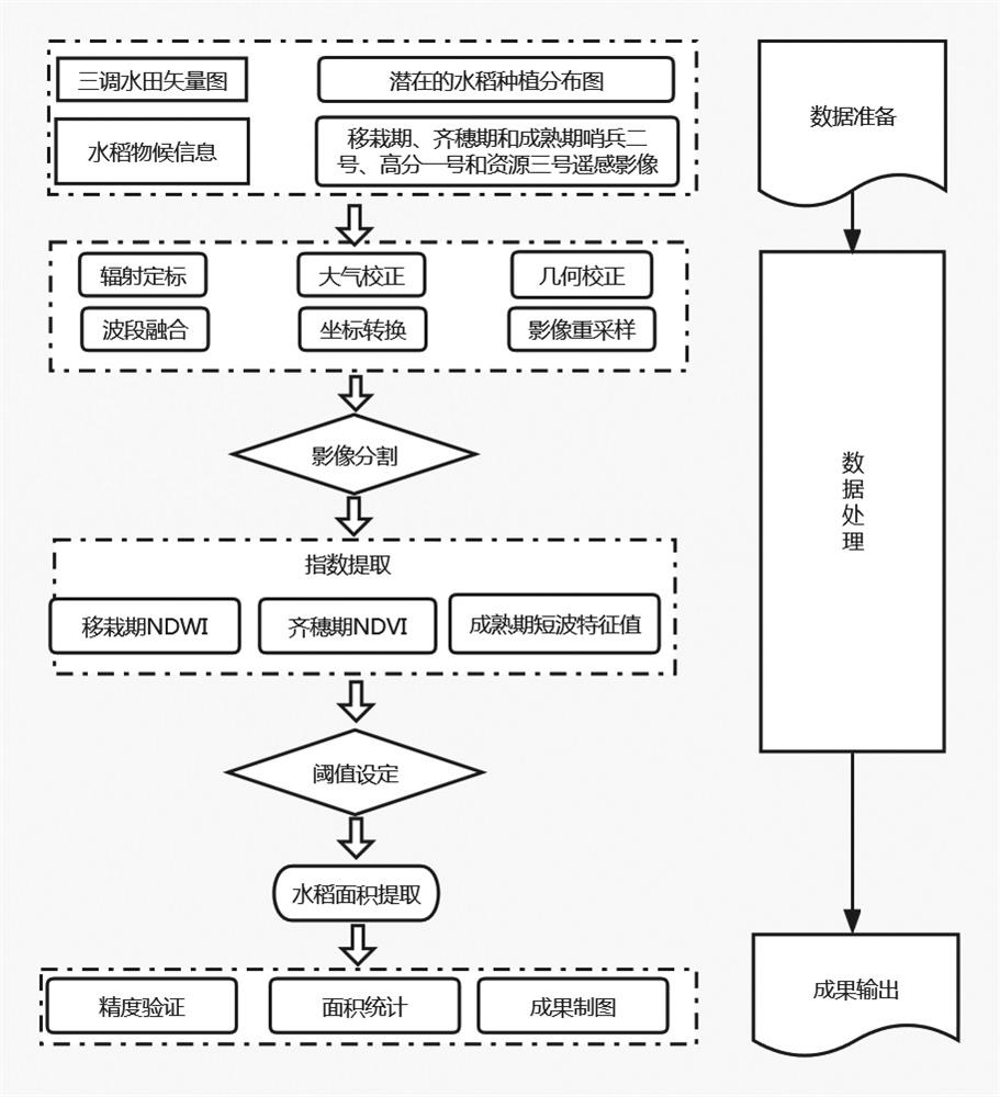
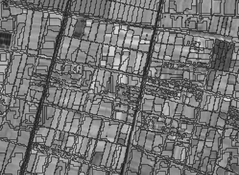
[0030] like figure 1 As shown, the method of the present invention comprises the steps:

[0031] 1. Obtain the paddy field vector data of the third national land survey. The paddy field refers to the cultivated land used to grow aquatic crops such as rice and lotus roots. Including cultivated land where aquatic and xerophytic crops are rotated.

[0032] 2. Obtain the information of the rice farming system and the time range of the phenological period in the study area.

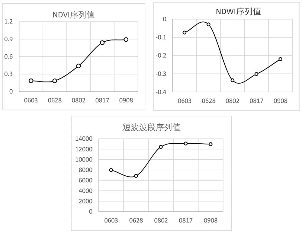
[0033] 3. Obtain the remote sensing images of the rice transplanting stage, full heading stage and maturity stage, as follows:

[0034] Table 1 Remote sensing images selected at the transplanting stage, full heading stage and mature stage of rice

[0035]

[0036] The full heading stage refers to the full heading stage when 80% or more of the rice plants in the whole field are heading (heading refers to the period or state in which the fully developed young ears of cereal crops protru...

Example Embodiment

[0051] Example 2

[0052] In this embodiment, the extraction of rice planting distribution in Lianyungang City in 2021 is taken as an example, and the method for rice identification, planting area extraction and rice planting distribution map production based on multi-source data and multi-temporal remote sensing data described in this application is described in detail.

[0053] (1) Data acquisition:

[0054] Paddy field vector data: data from the third land survey of Lianyungang City

[0055] Remote sensing data: Combined with the time information of the rice farming system and key phenological periods in Lianyungang City in 2021, and based on the screening conditions of remote sensing images of no clouds and few clouds, the remote sensing data of rice in Lianyungang City in 2021 were obtained. No. WFV 16 meters (2021.06.25-2021.07.10), and Sentinel No. 2 10 meters (2021.06.25-2021.07.10), No. 3 resources in full bloom period 2 meters (2021.7.20-2021.8.31) and high scores ...


PUM


Abstract

The invention relates to a rice planting area extraction method based on multi-source data, which combines multi-source remote sensing image data and paddy field vector data to realize rice identification and planting area extraction, and obtains cultivation system information of rice in a research area and a time range of a phenological period. Performing feature extraction on different phenological periods by adopting different remote sensing image data, identifying a suspected rice planting area, and finally extracting rice based on a set rice extraction rule. Aiming at the problem of obtaining the rice planting area, the rice distribution and the planting area are accurately and rapidly extracted by obtaining the multi-source remote sensing data of the research area and fusing the third-time land area survey data. The method is wide in application range and high in precision. The method solves the problem of long time for artificially estimating rice area data, reduces the investment of manpower, material resources and financial resources, improves the precision of extracting rice area by the existing remote sensing technology, and provides technical support for accurate extraction of rice area.

Description

technical field [0001] The invention relates to the technical field of agricultural remote sensing, in particular to a method for extracting rice planting area based on multi-source data. Background technique [0002] Rice is the main food crop in my country, and it is of great practical significance to know the sown area and spatial distribution of rice in a timely and accurate manner for guiding food production and food security. For a long time, the sown area of ​​grain has been formed by sampling survey and reporting and summarizing step by step. [0003] At present, there are two ways to obtain the sown area of ​​rice. One is formed by sampling survey and level-by-level reporting and summary. For example, the national grain production takes the province as the overall grain sampling survey, which is carried out in the national survey counties (cities). During the survey season, the investigators and auxiliary investigators of the survey teams of the National Bureau of ...

Claims


Application Information

Patent Timeline
IPC IPC(8): G06V20/13G06V20/10G06V10/26G06V10/40
CPCG06V20/13G06V20/188G06V10/26G06V10/40
Inventor 王轶虹王冬梅梁文广王宗伟秦慧杰
Owner JIANGSU WATER CONSERVANCY SCI RES INST
Why Eureka
Try Eureka