
Distributed GIS space information integration apparatus and method based on mobile Agent and GML

A technology of spatial information and integrated devices, which is applied in the branch offices providing special services, data exchange through path configuration, data exchange details, etc.

Inactive Publication Date: 2005-06-29
WUHAN UNIV
View PDF0 Cites 34 Cited by
  • Summary
  • Abstract
  • Description
  • Claims
  • Application Information

AI Technical Summary

Problems solved by technology

In the application field of mobile Agent, there have been reports abroad on the application of mobile Agent in information retrieval, network automatic management, e-commerce, etc., but it has not been reported in the field of GIS.
In addition, from the perspective of GML technology, although more and more people realize that GML will play an important role in GIS, related research is just beginning, and many technical issues still need to be further studied and explored.

Method used


Image

  • Distributed GIS space information integration apparatus and method based on mobile Agent and GML
  • Distributed GIS space information integration apparatus and method based on mobile Agent and GML
  • Distributed GIS space information integration apparatus and method based on mobile Agent and GML

Examples


Embodiment Construction

[0036] Further illustrate the present invention below in conjunction with accompanying drawing.

[0037] MAGGIS System Framework and Distributed Geographical Information Query

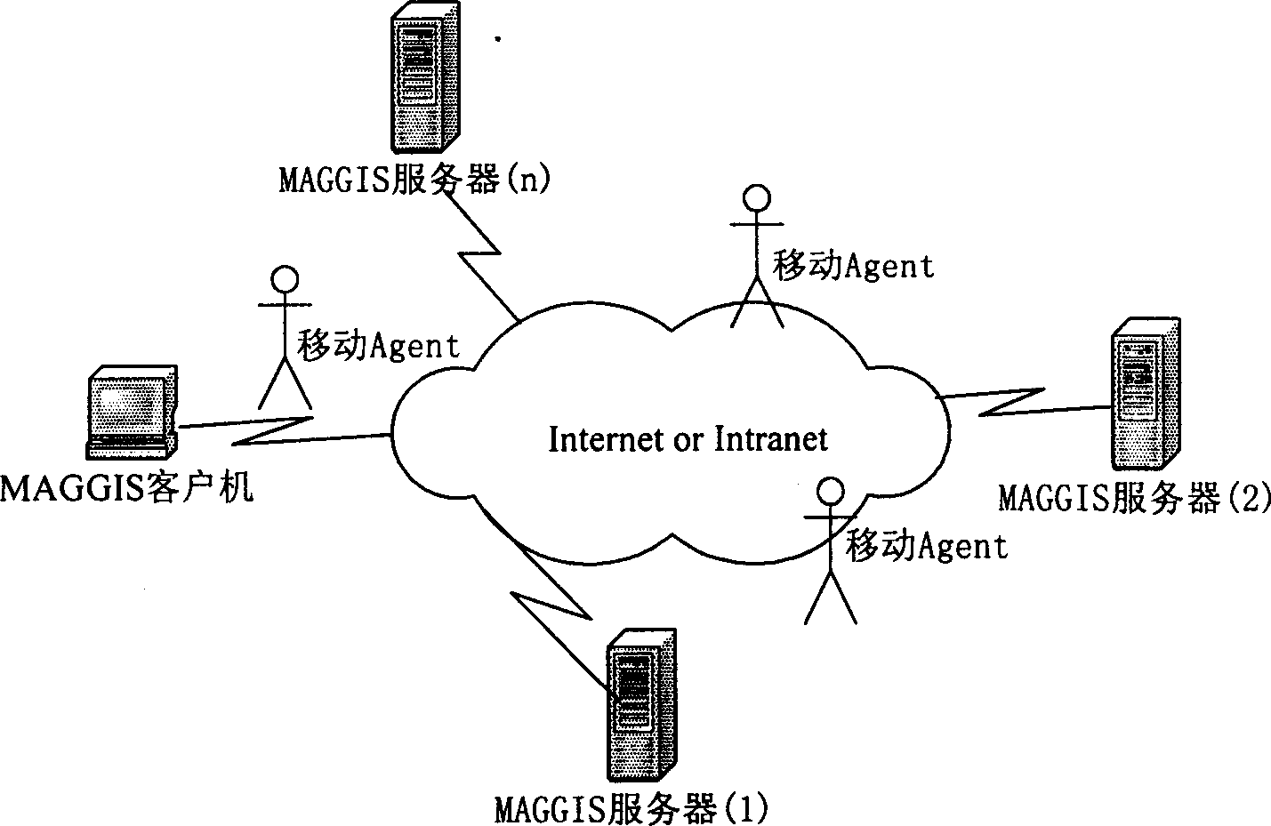
[0038] The MAGGIS system supports transparent access to Web GIS, information sharing and interoperability. The system is mainly composed of four parts: client, server, Internet or internal network connecting end nodes, and performing information access and retrieval tasks on behalf of users in the network. Mobile Agent. The structure of the system is as figure 1 shown.

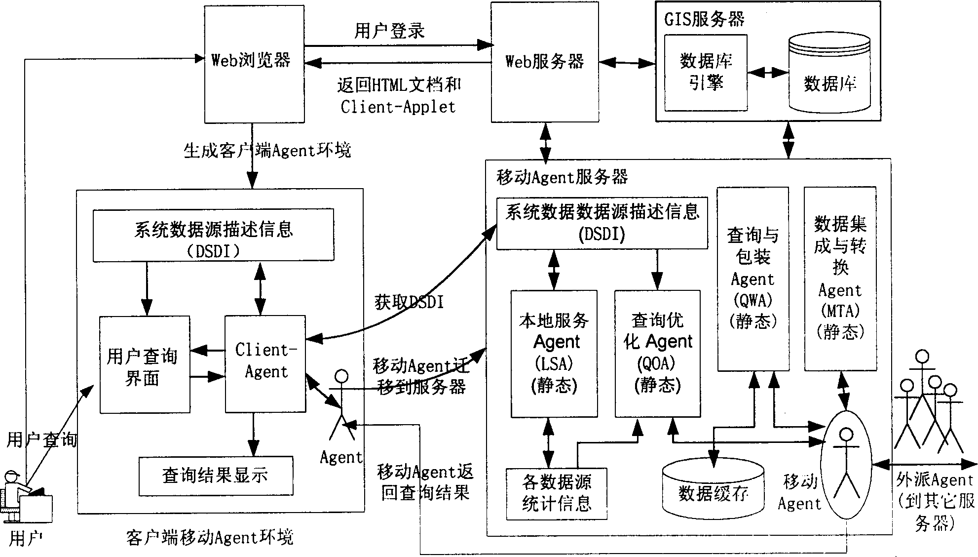
[0039] The main task of the client is to form and submit queries through interaction with users, and to display query results; users access a certain MAGGIS server in the MAGGIS system through the client or the local MAGGIS server, and the visited MAGGIS server returns a web page to the client. page; there is a Java Applet (called Client-Applet) in the page, which contains a Mobile Agent Environment (MAE), a static Agent and a mobil...


PUM


Abstract

This invention relates to a distributed GIS spatial information- integrating device and a method based on mobile agent and GML. The device includes a MAGGIS system frame of distributed geographical information inquiry, an operation device, a conversion device, a computing device, a display device, an inquiry device, a communication device and a safety device of mobile agent in MAGGIS. The invented method puts forward the distributed GIS structure, integration and an issuing system structure based on mobile agent, GML and SVG against the new requirement of spatial information acquirement, integration and issue under the Web environment by setting up mobile agent environment to finish acquiring spatial information, applying GML standard to realize package and integration to the distributed and isometric spatial information providing GML mode match and integration pan and applying SVG standard to carry out general display and interacted operation to maps to realize web issue of spatial information.

Description

technical field [0001] The invention belongs to the technical field of spatial information acquisition and processing in information technology, and in particular relates to the integration of distributed GIS spatial information based on mobile Agent and GML under the Internet environment of wide area, heterogeneity, low bandwidth, scattered information sources, and unstable connection Devices and methods. Background technique [0002] With the rapid development of the Internet (Internet) and the widespread use of the Web (network), GIS (Geographic Information System) has gradually changed from a centralized system used by professionals to a distributed and popular network information system. The isolated and independent centralized GIS system built for a long time can no longer meet the urgent needs of people in the Internet era for sharing and interoperating spatial information. Therefore, the present invention must seek a feasible way in theory and technology to efficien...

Claims


Application Information

Patent Timeline
Patent Type & Authority Applications(China)
IPC IPC(8): H04L12/16H04L12/28H04L29/06
Inventor 关佶红周水庚边馥苓陈晓龙朱付保王雷春虞为王荣刘旭军
Owner WUHAN UNIV
Learn More