Digital map position information compressing method and device

A technology of digital map and location information, applied in the directions of vehicle location indication, map/plan/chart, image coding, etc., can solve the problems of reducing data compression coefficient, hindering the accurate transmission of road shape, and the shape of the receiver deviates from the original shape, etc. achieve the effect of increasing the compression factor

Inactive Publication Date: 2006-07-19
PANASONIC CORP
View PDF3 Cites 5 Cited by
  • Summary
  • Abstract
  • Description
  • Claims
  • Application Information

AI Technical Summary

Problems solved by technology

[0043] ② When the angle component indicating the position of the sampling point is quantized in units of δ, as shown in FIG. Compensate for this deviation from the shape of the road in units of , so resample it in its deviation to the opposite side of the road, and repeat the process, thus placing samples in a zigzag fashion due to the resampling point phenomenon
[0044] This zigzag phenomenon prevents accurate transmission of the road shape to the receiver and reduces the data compression factor
[0045] ③ When the road shape is represented by the offset angle of the sampling point or the difference value of the offset angle estimate for transmission, the offset angle or the difference of the offset angle estimate indicating the position of the sampling point after the straight line shape of the road has been resampled In the case of quantizing the value, since the error generated by the quantization has an influence on the subsequent orientation, there may be a situation where the reproduced shape at the receiver greatly deviates from the original shape

Method used


Image

  • Digital map position information compressing method and device
  • Digital map position information compressing method and device
  • Digital map position information compressing method and device

Examples


no. 1 example

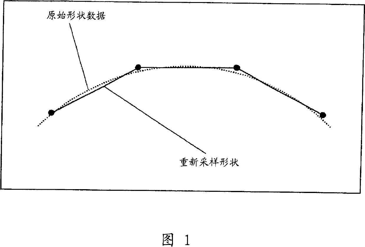
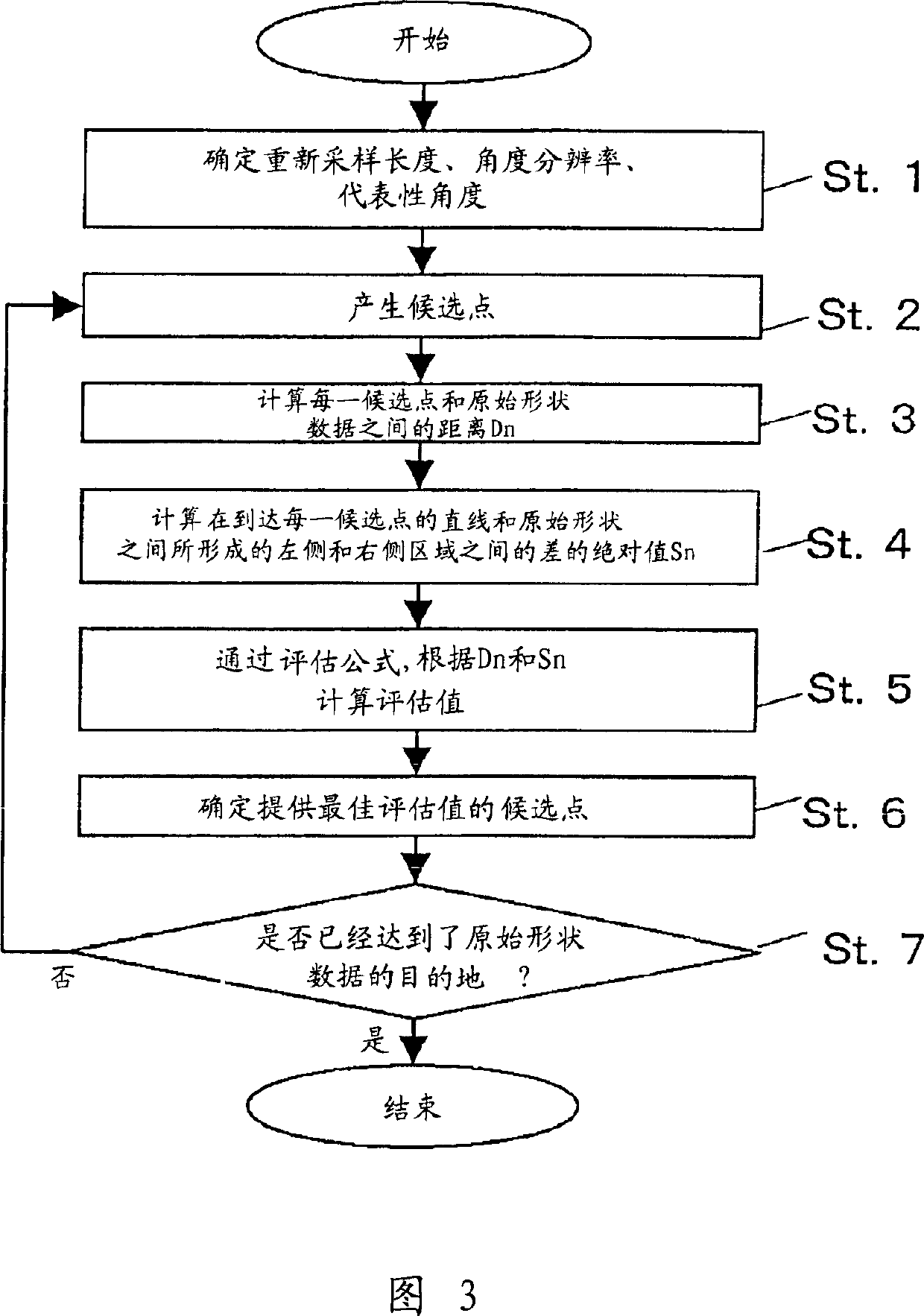
[0106] In the resampling method according to the first embodiment of the present invention, sampling points are set by paying attention to a region between a straight line linking the sampling points and the original shape.

[0107] In the process of resampling the shape of a road, equidistant resampling is performed on the target road after the resampling length L and the angular resolution (ie, the unit of quantization representing the position data of sampling points by angle) δ are determined.

[0108] When a curved road with a large curvature or a road in a mountainous area in which many such curved roads exist is the object of resampling, the resampling length L is set to be short, and when a straight road with a small curvature or in which many such curved roads exist When the road in the urban area of ​​the straight road is the target of resampling, set the resampling length L to long. For example, as shown in FIG. 4 , the resampling length L1 for equidistantly resampl...

no. 2 example

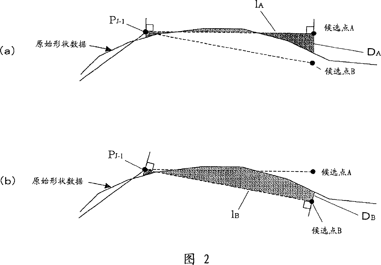
[0128] In the resampling method according to the second embodiment of the present invention, in the process of setting the sampling points, the lengths of the line segments of the original shape located on the left and right sides of the resampled shape are considered instead of the area.

[0129] In this resampling method, the process performed before setting candidates for sampling points is the same as the process performed before setting candidates for sampling points in the first embodiment. When the setting of a plurality of candidate points has been completed, as shown in FIG. In the case where the length of the line segment becomes the original shape on the left and right sides, sampling points are selected from the candidate points thus set.

[0130] When such a case occurs, the following formula (2) is used as the evaluation formula, and the candidate point providing the minimum evaluation value is used as the sampling point PJ.

[0131] Evaluation value of candidat...

no. 3 example

[0144] In the resampling method according to the third embodiment of the present invention, sampling points are set in consideration of the maximum error between the resampled shape and the original shape.

[0145] In this resampling method, the process performed before setting candidates for sampling points is the same as the process performed before setting candidates for sampling points in the first embodiment. When the setting of a plurality of candidate points has been completed, as shown in FIG. In the case of a balance between the maximum errors on both sides (that is, the maximum distance from the straight lines 1A, 1B to the shape data), sampling points are selected from the candidate points thus set.

[0146] When such a case occurs, the following formula (3) is used as the evaluation formula, and the candidate point providing the minimum evaluation value is used as the sampling point PJ.

[0147] Evaluation value of candidate point n=αDn+β(|Enr-Enl|) (3),

[0148]...


PUM


Abstract

A method and device for compressing data on position information. The shape vector of an object road section is re-sampled, and the sampling point is expressed by digitized angle information. For example, in a method in which the angle resolution delta serving as the angle digitization unit is adequately determined to compress the position information, the re-sample interval is determined according to the predetermined re-sample length L, the shape of a road shown in the digital map is divided into one or more sections, the shape of the road in each section is re-sampled with the predetermined re-sample length L, the position of the road shape is expressed by a data sequence of the digitized angle information representing the position of the sampling point, the data on this data sequence is converted into variable-length codes, and the codes are transmitted. The angle resolution delta is varied with the re-sample length L so that the angle resolution delta is made small when the re-sample length is long or made larger when it is short. Thus, information on a position such as of a road can be correctly transmitted with a small amount of data.

Description

technical field [0001] The present invention relates to a method for compressing data such as location information of roads on a digital map, and an apparatus for implementing the method, and more particularly, the present invention relates to a method for accurately transmitting a location with a small amount of data with equipment. Background technique [0002] Conventionally, in VICS (a road traffic information communication system), there has been a service of providing road traffic information to a vehicle navigation system in which a digital map database is installed through FM multicast or beacon, so The above road traffic information indicates the road segment or travel time where the traffic jam occurred. The car navigation system receives road traffic information to display colored road sections where traffic jams occur on a map displayed on the screen, or to calculate the time required to reach a target point for display. [0003] Thus, when providing road traff...

Claims


Application Information

Patent Timeline
IPC IPC(8): G09B29/00G06T9/20G08G1/13H03M7/42
Inventor 足立晋哉
Owner PANASONIC CORP
Why Eureka
Try Eureka