Automobile dead reckoning positioning method and module

A technology of dead reckoning and positioning method, applied in road network navigators, navigation by speed/acceleration measurement, beacon systems using radio waves, etc. The effect of eliminating the influence of the horizontality of the installation position, accurate vehicle positioning information, and improving the positioning accuracy

Inactive Publication Date: 2006-09-06
BEIJING SPACE DINGYI SCI & TECH DEV
View PDF0 Cites 27 Cited by
  • Summary
  • Abstract
  • Description
  • Claims
  • Application Information

AI Technical Summary

Problems solved by technology

[0003] The traditional inertial navigation technology using angular velocity sensors and acceleration sensors can realize the autonomous positioning of vehicles. The accumulative error of braking and acceleration will be very large. Generally, the odometer of the car is used to measure the speed of the car.
[0004] Due to the popularization of automobiles and the maturity of GPS, more and more satellite navigation systems are used in automobiles. The basis of vehicle satellite navigation systems is to accurately and continuously locate automobiles. The reason is that satellite signals cannot be received in many areas; and due to the multipath effect of radio waves brought by large urban buildings, the positioning accuracy of GPS is greatly reduced; in jungle areas or in cities with tall trees, due to the influence of leaves on radio waves GPS positioning is unreliable; the consequence is that it cannot provide continuous and accurate vehicle positioning, which affects the use of satellite navigation systems; in mountainous areas and roads with many tunnels, when using GPS as the basis for driving records, it will also cause driving problems. Incomplete or wrong data recording

Method used


Image

  • Automobile dead reckoning positioning method and module
  • Automobile dead reckoning positioning method and module
  • Automobile dead reckoning positioning method and module

Examples


Embodiment Construction

[0023] The specific implementation manner of the present invention will be described below in conjunction with the accompanying drawings.

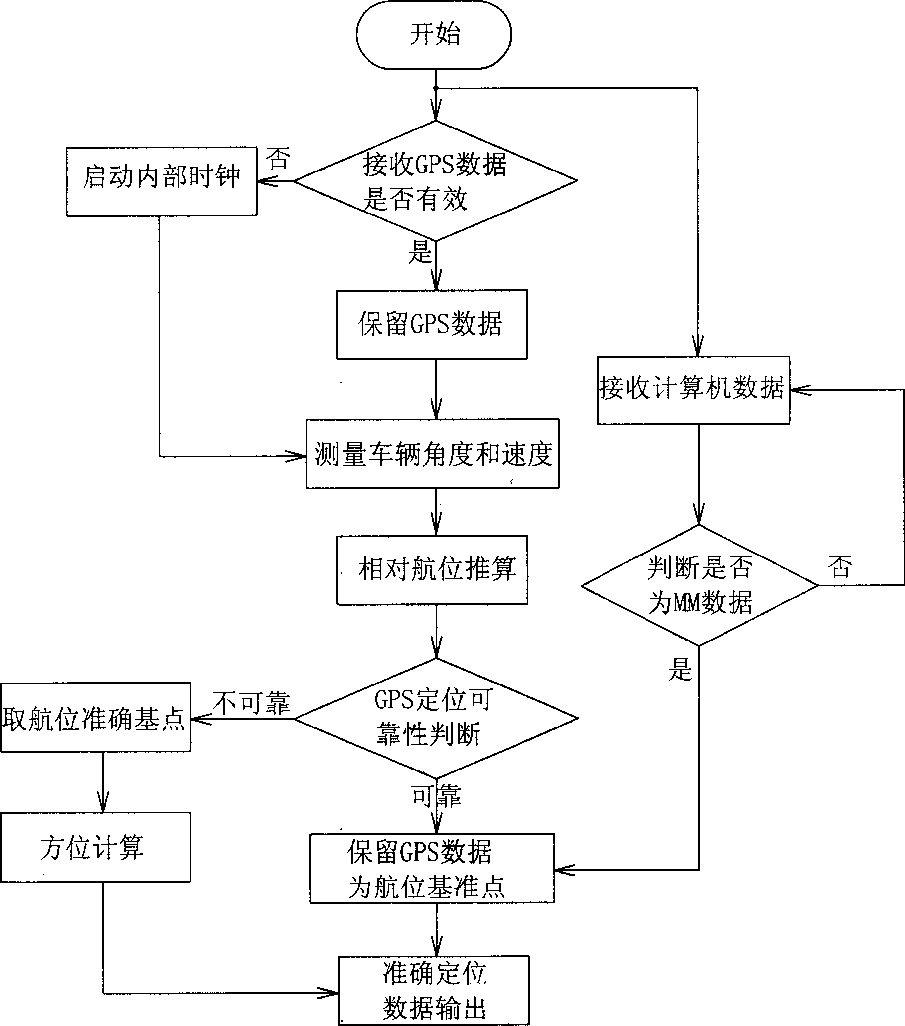
[0024] Such as figure 1 A vehicle dead reckoning positioning method combined with satellite positioning data is shown, the positioning method includes the following steps: starting the vehicle and receiving GPS information, and judging the integrity of the GPS data received within the set time :

[0025] a. Receive complete GPS data, use the cycle of GPS data flow as the calculation period of dead reckoning, and keep valid information related to dead reckoning: time, longitude, latitude, horizontal error, altitude error, number of satellites, dead reckoning , speed, DGPS;

[0026] b. Unable to receive complete GPS data and start the internal clock as dead reckoning clock at the same time;

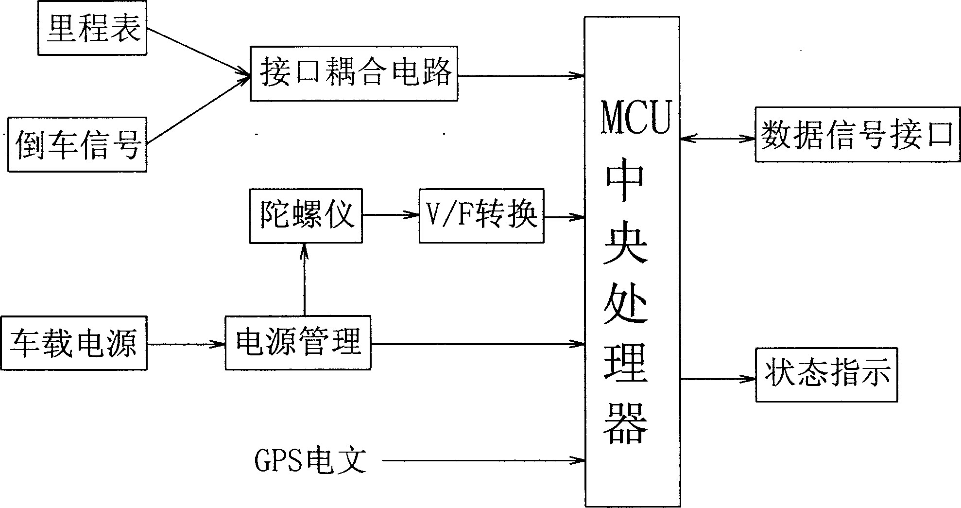
[0027] Then continuously detect the angle and speed of the vehicle change, use the value of the angle and speed to perform dead reckoning to calcula...


PUM


Abstract

The disclosed dead reckoning and positioning method combines satellite positioning data and comprises: receiving GPS signal, while detecting continually the vehicle angle and velocity; according to effective satellite number and horizontal error and the latitude and longitude variable error, deciding the reliability of GPS data flow for accurate positioning. This invention has well autonomy and precision, and will play important role in future satellite navigation technique and vehicle drive record technique.

Description

technical field [0001] The invention relates to a vehicle dead reckoning positioning method combined with satellite positioning data and a corresponding positioning module. Background technique [0002] In modern vehicle satellite navigation and positioning technology, satellite positioning technology is widely used, such as the global positioning system (GPS) of the United States, GLONASS of Russia, and Beidou positioning system of China; With a GPS receiver installed on the vehicle, as long as the GPS receiver is installed on the vehicle, if the four satellite signals can be guaranteed to be received well, the vehicle's position, speed, direction of movement and other elements can be accurately known, and the control system can realize navigation by referring to the electronic map. [0003] The traditional inertial navigation technology using angular velocity sensors and acceleration sensors can realize the autonomous positioning of vehicles. The accumulative error of bra...

Claims


Application Information

Patent Timeline
Patent Type & Authority Applications(China)
IPC IPC(8): G01C21/12G01C21/26G01S1/08
Inventor 王三喜林志坚
Owner BEIJING SPACE DINGYI SCI & TECH DEV
Why Eureka
Try Eureka