System and method for providing information, a location data collection system, and a car navigation system

A technology of location information and collection devices, applied in the direction of selection devices, traffic control systems, road vehicle traffic control systems, etc., can solve the problems of not being able to reduce the risk of traffic accidents, not being able to prevent accidents, and reduce the possibility of traffic accidents Effect

Inactive Publication Date: 2006-11-29
HITACHI LTD
View PDF1 Cites 10 Cited by
  • Summary
  • Abstract
  • Description
  • Claims
  • Application Information

AI Technical Summary

Problems solved by technology

[0006] However, in the prior art described above, the road crossing behavior is detected after the carrier of the mobile phone device starts crossing the road, so if the vehicle is close to the crossing person, even if the car navigation device sends Alarm, I'm afraid it won't prevent accidents
In addition, in the case of pedestrians walking along the road, no alarm is issued, so the risk of traffic accidents cannot be reduced especially at night, etc., when the driver of the vehicle does not see such pedestrians. sex

Method used


Image

  • System and method for providing information, a location data collection system, and a car navigation system
  • System and method for providing information, a location data collection system, and a car navigation system
  • System and method for providing information, a location data collection system, and a car navigation system

Examples


Deformed example -1

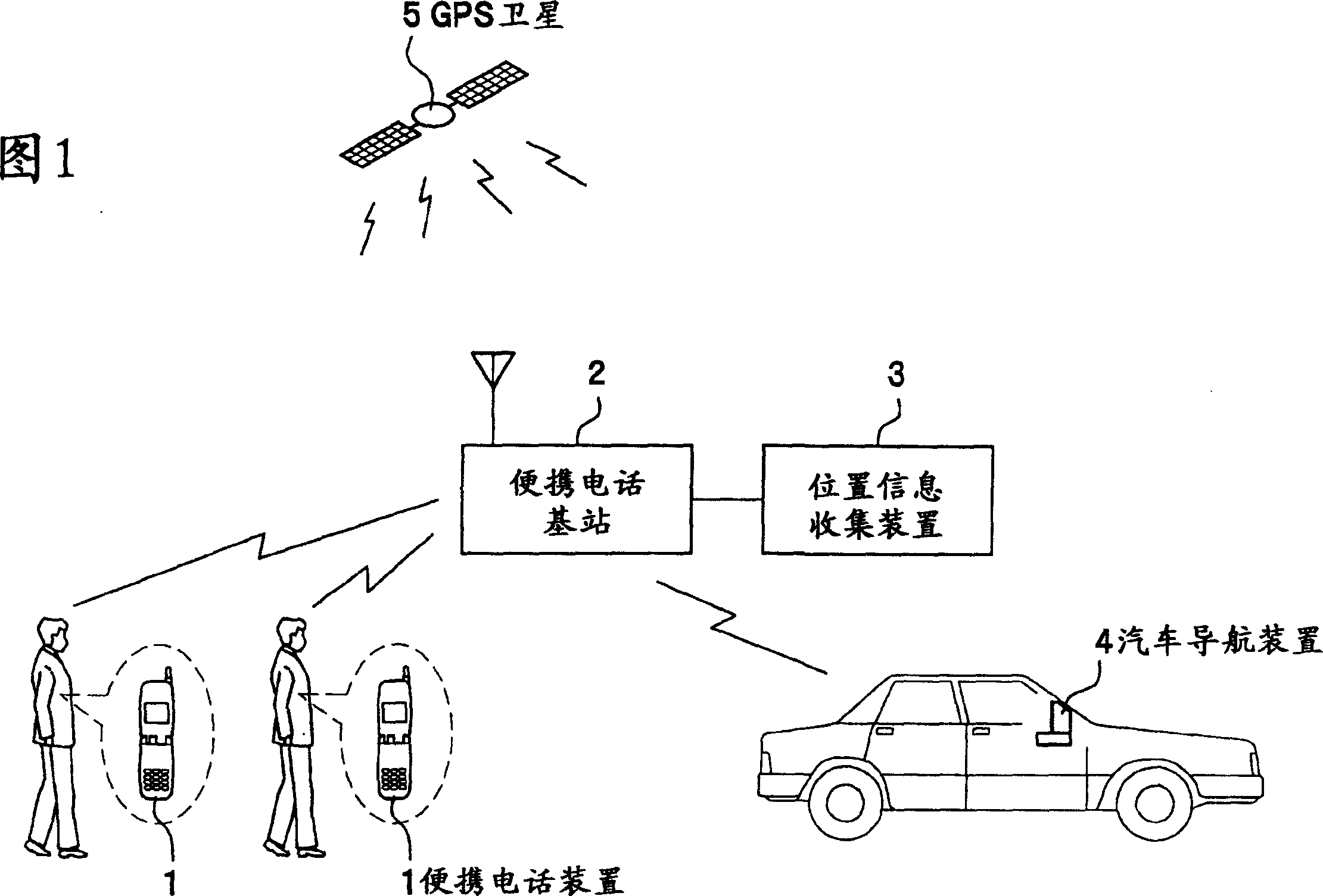
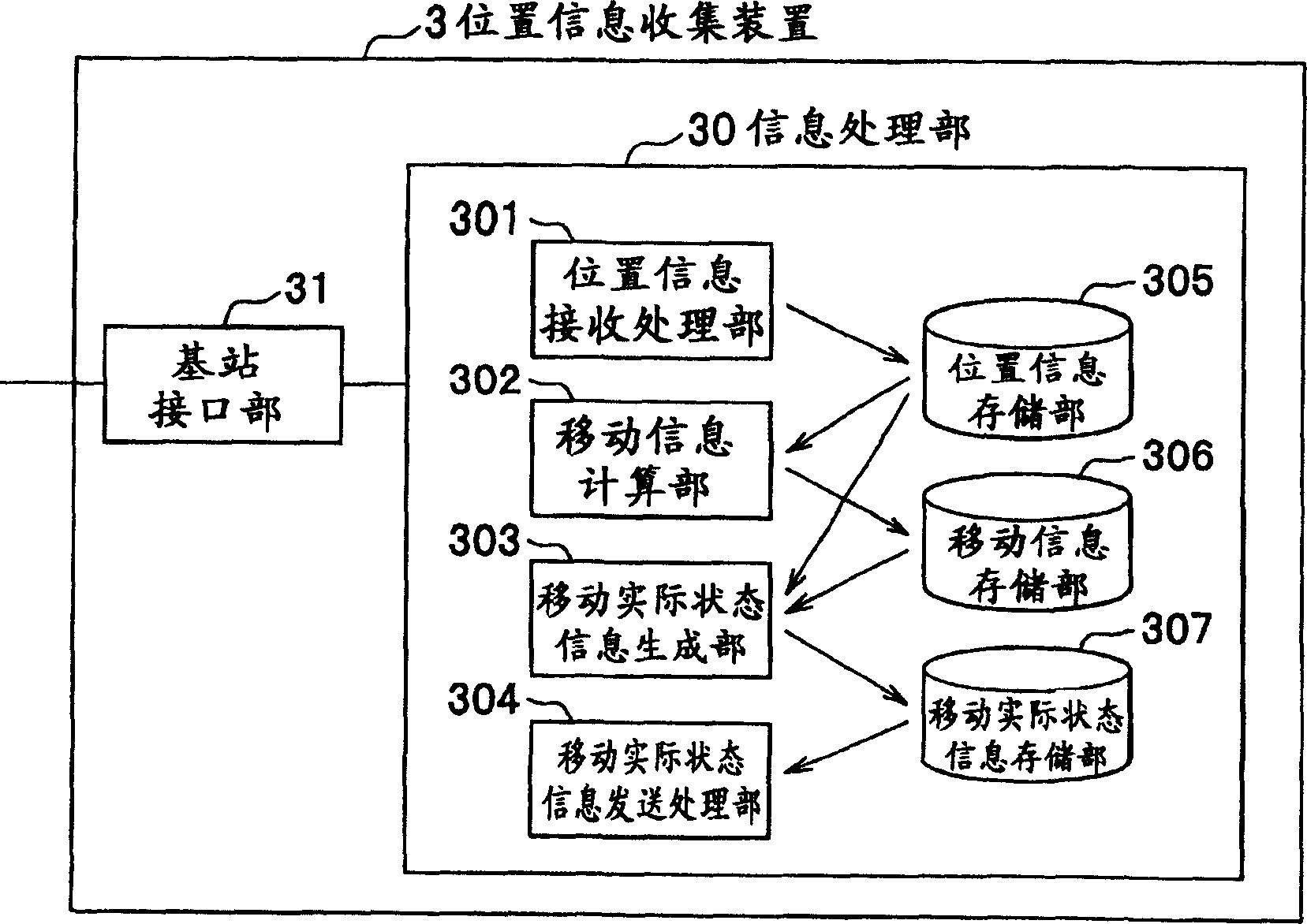
[0072] In the above embodiment, if Figure 2 to Figure 8 As shown, the location information collection device 3 performs most of the information processing related to the location information of the mobile phone device 1, and transmits the information of the actual moving state information storage unit 307 as a result to the car navigation device 4. However, in In Modification-1 of the present embodiment, most of the information processing is performed by the car navigation device 4 . Such a change is possible because the car navigation device 4, like the positional information collecting device 3, also has an information processing unit including an arithmetic processing unit and a storage unit composed of a semiconductor memory or a hard disk device.

[0073] Therefore, in this case, the positional information collection device 3 only performs a function of temporarily storing positional information transmitted from the mobile phone device 1 located in a predetermined area, ...

Deformed example -2

[0078] In the above original embodiment, the position information measured by the mobile phone device 1 based on the radio waves of the GPS satellite 5 is used as the position information of the mobile phone device 1 . In this case, an error of about 10 m to 20 m occurs in the measured position information. Therefore, in Modification-2 of the present embodiment, near-field communication devices indicating their positions are installed at roadsides or the like along the road, for example, at intervals of 10 m to 20 m. In addition, the mobile phone device 1 also has a short-range wireless communication unit capable of communicating with the short-range wireless communication device, and the mobile phone device 1 obtains the position information by receiving the position information transmitted from the short-range wireless communication device on the roadside. Moreover, at this time, the mobile phone device 1 may use the position information itself transmitted from the short-ran...

Deformed example -3

[0082] In the above original embodiment, the mobile phone device 1 has means for measuring its own position. In Modification-3 of the present embodiment, when the mobile phone device 1 does not have a position measuring unit, means for obtaining position information of the mobile phone device 1 is provided.

[0083] In Modification 3 of the present embodiment, the mobile phone base station 2 includes, for example, antennas with directivity in the directions of east, west, north, south, and each direction. The signals transmitted from the mobile phone device 1 are received through these antennas. The receiving level of the mobile phone device 1 is measured. For example, if the reception level obtained from the antennas in the east-west direction is Ex (where, it is a positive number in the case of the east direction and a negative number in the case of the west direction), the reception level obtained from the antennas in the north-south direction is When the level is Ey (a po...


PUM


Abstract

A mobile phone base station sends to a mobile phone device information requesting location data thereof, receives location data sent back by the mobile phone device according to the information, and outputs the location data to a location data collection system. The location data collection system inputs the location data, and generates state-of-move information constituted from a location distribution, a moving speed distribution, and a moving direction distribution, or information obtained by filing these information, based on the location data. Then, the location data collection system broadcasts the generated state-of-move information to the car navigation system located in a predetermined area through the mobile phone base station. The car navigation system displays the received state-of-move information on a screen of a display unit thereof with a map indicating the vicinity of the location of the vehicle.

Description

technical field [0001] The present invention relates to a mobile body moving actual state information providing system, a location information collection device, a car navigation device and a moving body moving actual state information providing method, which are used to provide location information based on wireless terminal devices such as portable telephone devices. The actual moving status information such as the position distribution, moving speed distribution, and moving direction distribution of moving objects such as pedestrians is provided to the car navigation device. Background technique [0002] In recent years, the popularity of mobile phone devices has been astonishing, and it is said that 2 out of every 3 people in the entire population now carry a mobile phone device. Further, provision of a navigation system for pedestrians by mounting a position detection function using, for example, GPS (Global Positioning System) on a mobile phone device has been commerci...

Claims


Application Information

Patent Timeline
Patent Type & Authority Applications(China)
IPC IPC(8): G08G1/01G08G1/0968G08G1/00H04Q7/38H04W64/00
CPCG08G1/164
Inventor 盐谷真菅原敏宮崎秀一野中尚道三田村健一
Owner HITACHI LTD
Why Eureka
Try Eureka