Tool for onsite augmentation of reality meshes

a technology of augmented reality and meshes, applied in the field of augmented reality, can solve the problems of difficulty in accessing when, unable to develop a robust system that is robust enough for widespread adoption in infrastructure design and maintenance space, and augmented reality systems continue to be hindered, so as to avoid the problem of camera tracking

Active Publication Date: 2019-12-03
BENTLEY SYST INC
View PDF8 Cites 8 Cited by
  • Summary
  • Abstract
  • Description
  • Claims
  • Application Information

AI Technical Summary

Benefits of technology

[0007]In one embodiment, augmented reality is simulated by augmenting a pre-generated, physical environment-aligned 3D reality mesh. A 3D reality mesh is generated in advance based on digital images and/or point clouds of a site. Metadata regarding infrastructure elements is assigned to the 3D reality mesh. Subsequently, the 3D reality mesh and metadata is accessed by a mobile device. A live position and live orientation of the mobile device is determined, and based thereon, a view of the pre-generated 3D reality mesh al...

Problems solved by technology

While such data has traditionally been diligently maintained, it has been difficult to access when relevant to a current task, for example, by engineers, workers or other users at a site.
However, while extensive research has been devoted to augmented reality systems, developing a system that is robust enough for widespread adoption in the infrastructure design and maintenance space has proved elusive.
Augmented reality systems continue to be hindered by several technical challenges.
First, camera tracking poses an ongoing challenge.
If there is error or uncertainty in the position of the camera, the quality of the augmented reality is greatly diminished.
Augmentations may appear in incorrect locations, such that a user cannot rely on them in their decision making.
Further, augmentations may appear to “jitter” about as camera tracking struggles to determine the correct position, causing visual distractions that may hinder usability.
The challenge of camera tracking is particularly acute in outdoor environments, in part due to changing illumination conditions (e.g., due to time of day), changing weather conditions, dynamically changing environmental features (e.g., cars and pedestrians moving on a street), and potential interference with positioning system s...

Method used


Image

  • Tool for onsite augmentation of reality meshes
  • Tool for onsite augmentation of reality meshes
  • Tool for onsite augmentation of reality meshes

Examples


Embodiment Construction

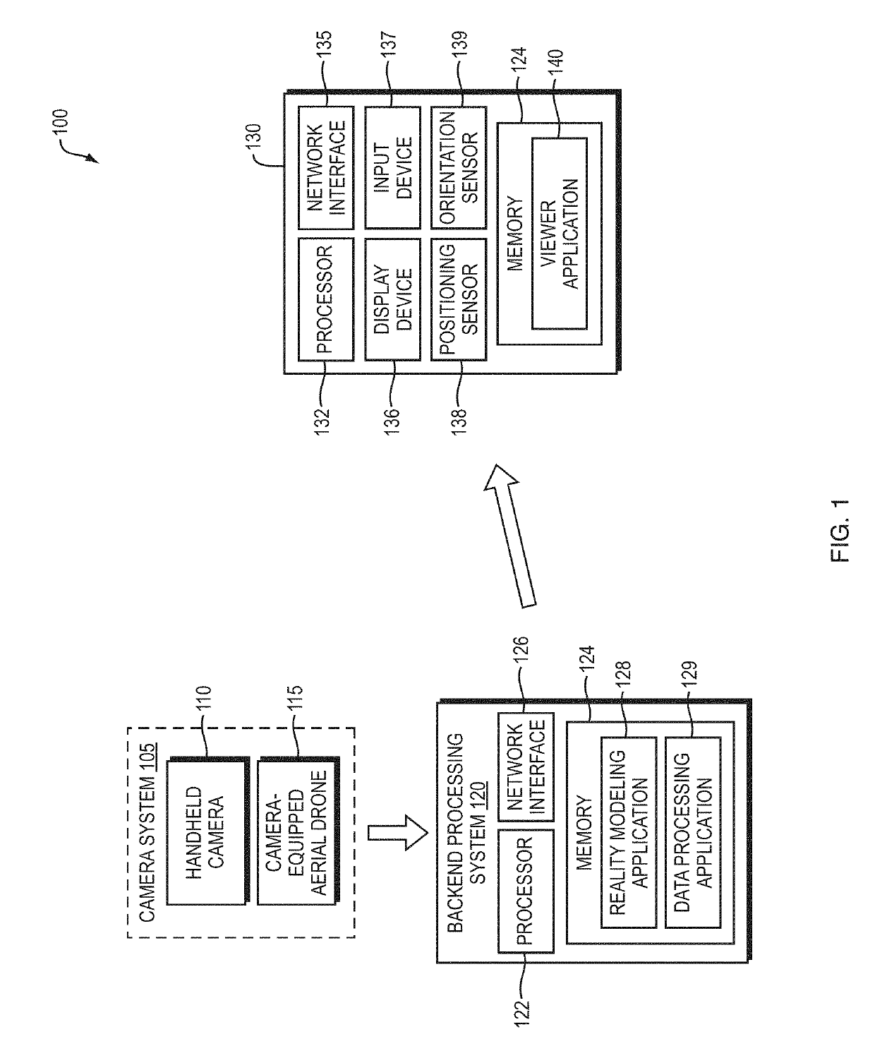
[0018]FIG. 1 is a diagram of an example system 100 for simulating augmented reality by augmenting a pre-generated, physical environment-aligned reality mesh. The system includes a camera system 105, including a handheld camera 110 (e.g., a handheld digital single-lens reflex (DSLR) camera) and / or a camera-equipped aerial drone 115, for capturing a large number of digital images (i.e. photographs) of a site. The camera system may also potentially include a laser scanner or time of flight camera (not shown) for capturing point clouds of the site.

[0019]The digital images (and potentially point clouds) of the site are transferred to a backend processing system (e.g., a desktop computer, a cloud-based server, etc.). The backend processing system 120 includes at least a processor 122 and a memory 124 that stores software for execution on the processor, and a network interface 126. Among other software, the memory 124 may store a reality modeling software application 128 and a data process...


PUM


Abstract

In one embodiment, augmented reality is simulated by augmenting a pre-generated, physical environment-aligned 3D reality mesh. A camera system captures digital images of a site. A backend processing system generates a 3D reality mesh of the site based on the digital images, assigns metadata to infrastructure elements in the 3D reality mesh, and stores the 3D reality mesh and metadata. At a subsequent time, a mobile device accesses the 3D reality mesh and assigned metadata. A positioning sensor determines a live position of the mobile device. An orientation sensor determines a live orientation of the mobile device. Based on the live position and live orientation, a view of the 3D reality mesh aligned to the physical environment is produced and displayed on a display device of the mobile device. That view is then augmented based on the assigned metadata.

Description

BACKGROUNDTechnical Field[0001]The present disclosure relates to augmented reality, and more specifically, to techniques for simulating augmented reality using a pre-generated three dimensional (3D) reality mesh.Background Information[0002]Augmented reality has enormous potential for conveying data useful in infrastructure design and maintenance. While augmented reality has applicability to a wide variety of different types of infrastructure, one type it may be applied to is municipal assets (e.g., subsurface utilities, poles, hydrants, street lights, and other assets owned or managed by a municipality). Over the years, municipalities may accumulate enormous quantities of data related to municipal assets, such as pipe and other utility drawings and maps, two-dimensional (2D) or three-dimensional (3D) computer aided design (CAD) models, asset specifications, installation dates and maintenance schedules, inspection reports, repair documents, photos, videos, etc. While such data has tr...

Claims


Application Information

Patent Timeline
IPC IPC(8): G06T17/05G06T19/00G06T17/20G06F17/50
CPCG06T19/006G06T19/003G06T17/20G06F17/50G06F2111/18G06F30/00
Inventor CÔTÉ, STÉPHANEMÉNARD, MAXIME
Owner BENTLEY SYST INC
Why Eureka
Try Eureka