GPS based terrain referenced navigation system

Inactive Publication Date: 2002-12-12
BAE SYSTEMS PLC
View PDF7 Cites 24 Cited by
  • Summary
  • Abstract
  • Description
  • Claims
  • Application Information

AI Technical Summary

Problems solved by technology

However, many vehicle platforms do not carry an inertial navigation system, and therefore cannot use the TRN

Method used


Image

  • GPS based terrain referenced navigation system
  • GPS based terrain referenced navigation system
  • GPS based terrain referenced navigation system

Examples


Embodiment Construction

[0052] There will now be described by way of example the best mode contemplated by the inventors for carrying out the invention. In the following description numerous specific details are set forth in order to provide a thorough understanding of the present invention. It will be apparent however, to one skilled in the art, that the present invention may be practiced without limitation to these specific details. In other instances, well known methods and structures have not been described in detail so as not to unnecessarily obscure the present invention.

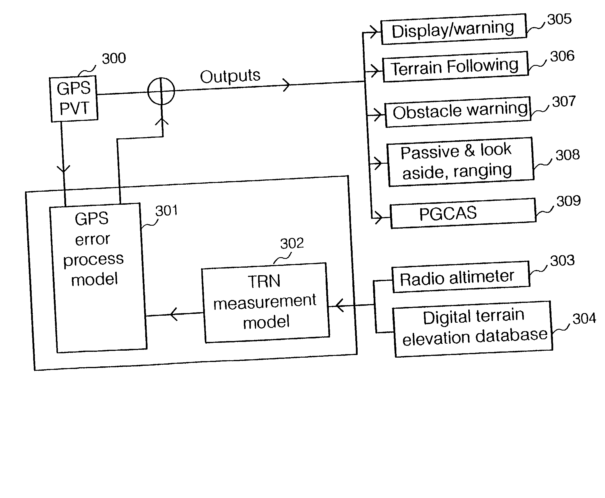
[0053] A best mode specific implementation according to the present invention allows terrain referencing of GPS navigation outputs directly, without the need for an inertial navigation system. This is achieved by basing a terrain referenced navigation system Kalman filter on an error model of a global positioning system.

[0054] Referring to FIG. 3 herein, there is illustrated schematically components of a navigation system according t...


PUM


Abstract

The terrain referenced navigation system uses data from a global positioning system (GPS) to determine a vehicles position, velocity and height above ground. The system uses input data from an altimeter device, a digital terrain elevation data, and a GPS position, velocity and time data. The system applies a GPS error process model in addition to a TRN measurement model, to obtain a state vector which includes estimates of current errors in the GPS data. The PVT data input from a GPS receiver is used to determine a current vehicle position and height in geographic axis. Using specifically constructed Kalman filter states, a geographical position and height of the vehicle is reference to the digital terrain elevation data, and an estimated ground clearance at the vehicle position is determined. The ground clearance is differenced with a radar altimeter output, and the residual is processed by Kalman filter to determine a new state vector, including estimates of current errors in the GPS data. The output can be configured to be either referenced to navigation axis, or to the digital terrain database for use by other digital terrain system functions.

Description

[0001] The present invention relates to navigation systems, and particularly although not exclusively, to a method and apparatus for providing a terrain referenced navigation system without the use of an inertial navigation system.BACKGROUND TO THE INVENTION[0002] Known airborne vehicle navigation systems are based on a wide range of known sensor technology, with a specific navigation system in a particular vehicle making use of the available sensor inputs from that vehicle, and availability of sensors depending upon the age and cost of the vehicle.[0003] Sensors which are most commonly available include:[0004] Air data systems (ADS), producing both air speed and Baro-altitude outputs;[0005] Attitude and heading reference systems (AHRS), outputting vehicle Euler angles;[0006] Radio altimeters (RA), having an output of a height above ground data.[0007] Other sensors which are sometimes available, depending on age and cost of the particular vehicle include inertial navigation systems ...

Claims


Application Information

Patent Timeline
IPC IPC(8): G01S1/00G01S5/14G01S13/86G01S13/935G01S19/15G01S19/47G01S19/50
CPCG01S13/86G01S13/94G01S19/50G01S19/47G01S19/15G01S13/935
Inventor DAY, LAURENCE
Owner BAE SYSTEMS PLC
Why Eureka
Try Eureka