Techniques for surface exploration and monitoring

Active Publication Date: 2005-02-03
ADVANCED GEOSCI
View PDF29 Cites 36 Cited by
  • Summary
  • Abstract
  • Description
  • Claims
  • Application Information

AI Technical Summary

Benefits of technology

[0049] In another respect, the invention involves a system for measuring a property of a surface, the system including a survey controller and a plurality of survey probes whose position relative to one another is automatically determined. This advantageously allows for much more efficient measurement techniques because the system can itself determine physical relative and/or absolute locations of probes. In one embodiment, a transmitting beacon is provided, and the position is determined using a signal from the transmitting beacon. In another embodiment, a radio frequency identification (RFID) system is coupled to the probes and a Global Positioning System (GPS) is used. The position is determined by combining identification information from the RFID system with positional location from the GPS. In another embodiment, the RFID system can alone be used to identify individual probes and report that information, including information about the relative ordering of the probes, to the survey controller. The survey probes can be in motion. In such an embodiment, even if the probes are being, e.g., pulled behind a boat, their relative positions can be continuously determined. This offers great advantages over the current state of the art.
[0050] In another respect, the invention involves a system for measuring a property of a surface, the system including a plurality of survey probes and a survey controller configured to supply power to the survey probes using a power conduit. The survey probes automatically electrically disconnect from the power conduit while measuring the proper

Problems solved by technology

Often specific survey objectives cannot be met by applying only one geophysical method.
This usually requires that equipment be in place for long periods of time and necessitates frequent visits to the survey sites by geophysical technicians to monitor changing subsurface conditions.
The present state of the art does not provide an effective way to remotely manage field equipment and monitor survey data, much less monitor data in real-time.
During a survey, one may discover that equipment performance has degraded or some components are not performing at all.
Presently, he or she must then contact a service technician by telephone to report the problem, resulting in lengthy and sometimes confusing attempts to diagnose the problem and repair the equipment.
Often, when equi

Method used


Image

  • Techniques for surface exploration and monitoring
  • Techniques for surface exploration and monitoring
  • Techniques for surface exploration and monitoring

Examples


Embodiment Construction

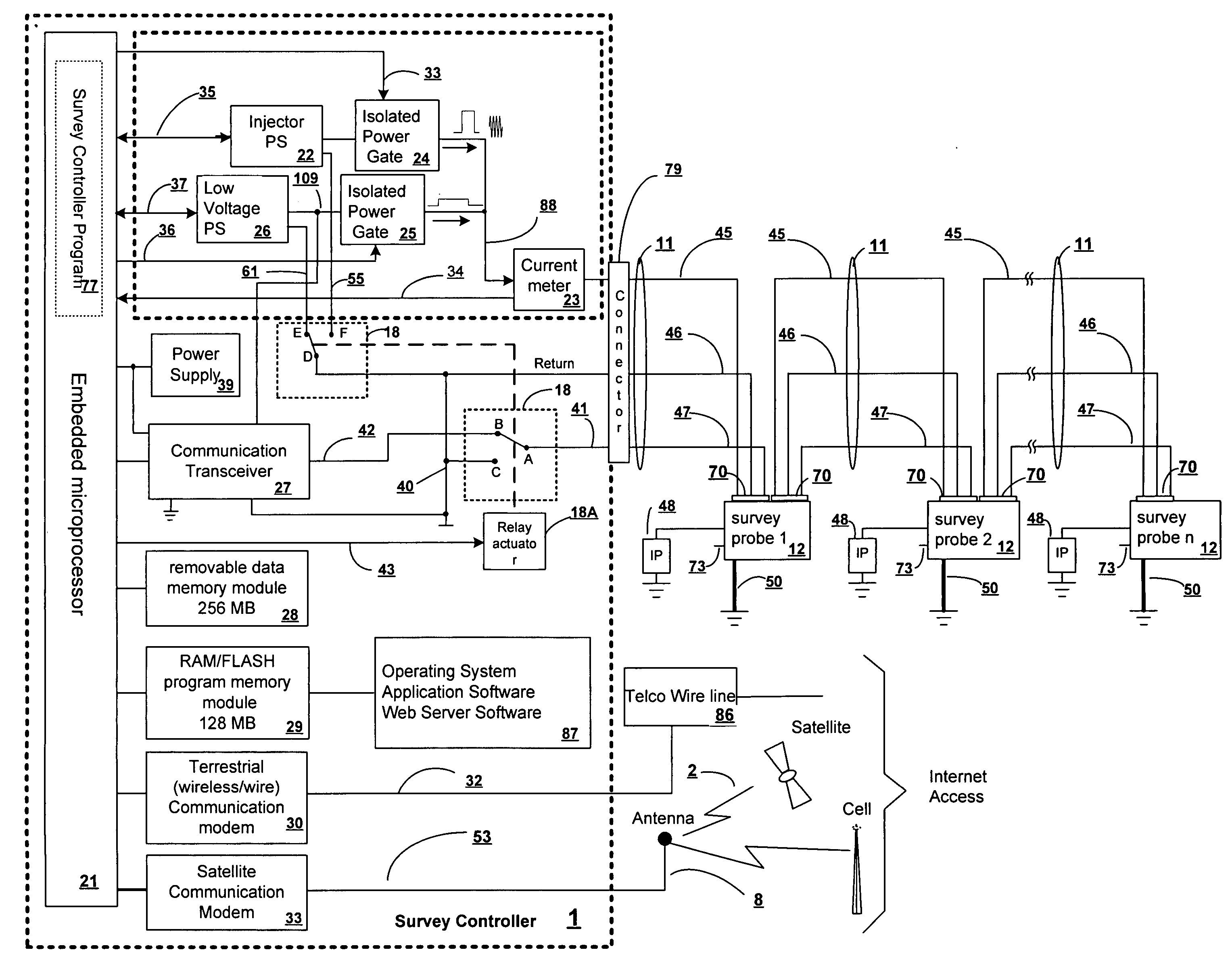
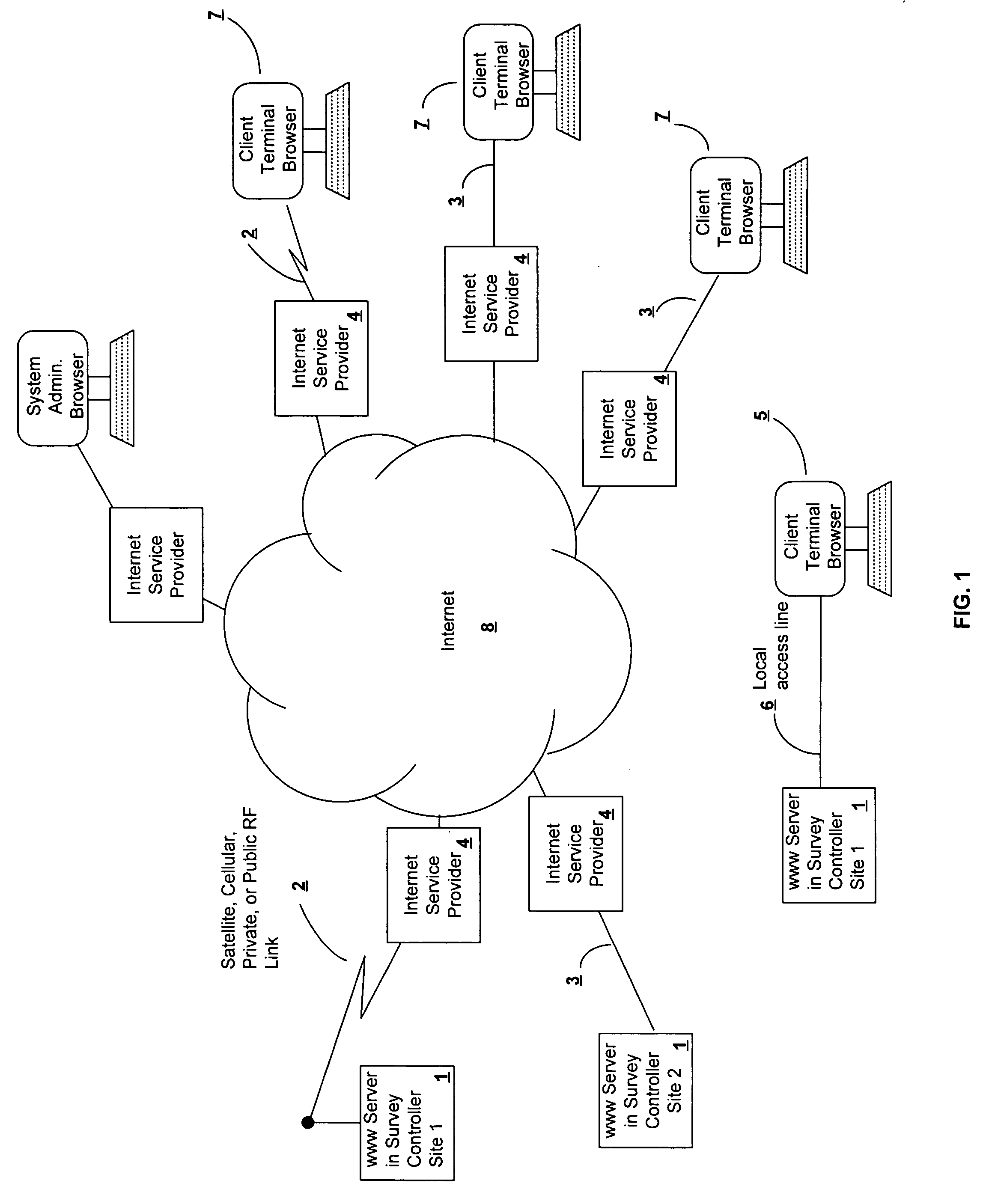
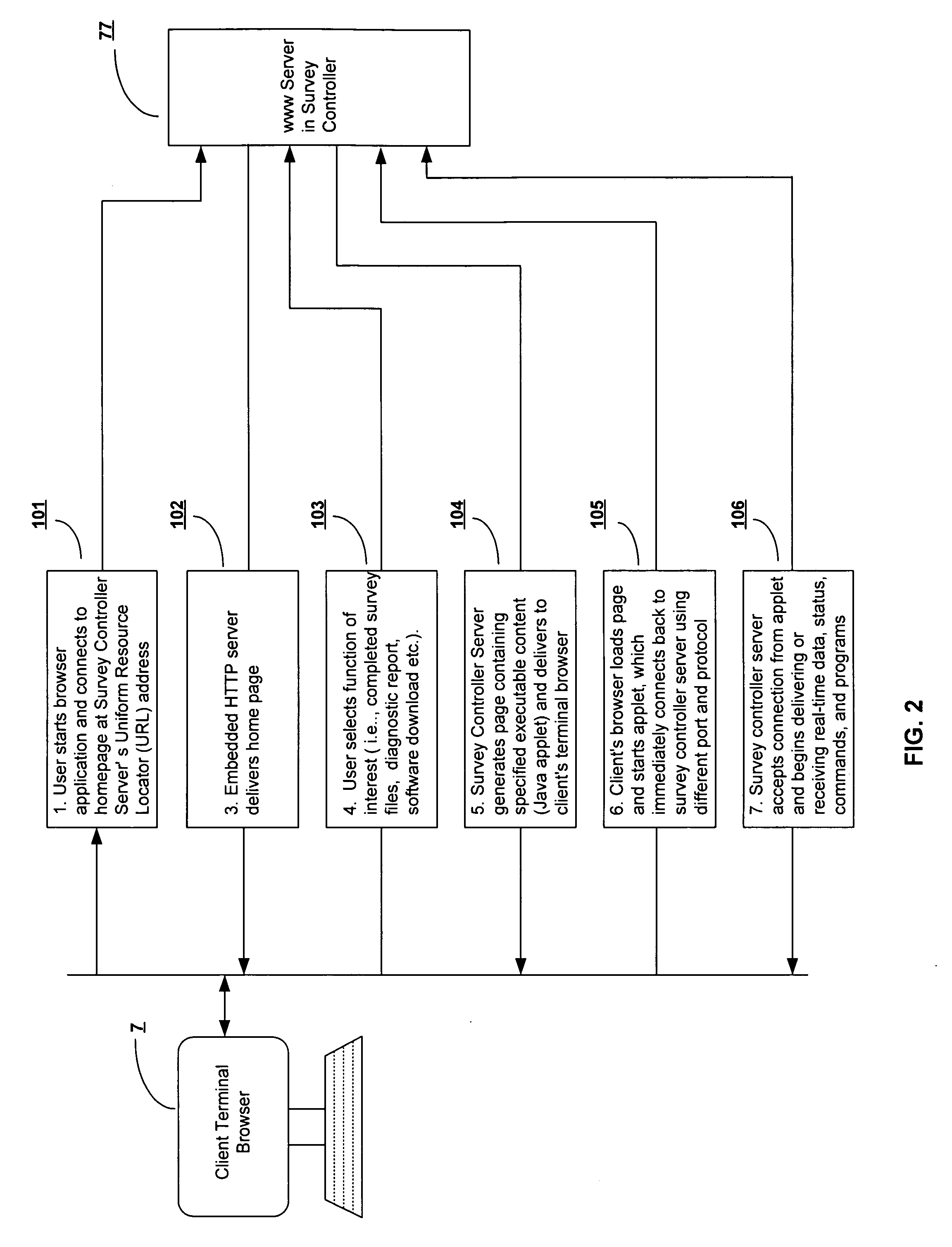
[0070] Referring now to the drawings it will be understood that the illustrations and accompanying text are provided to describe example embodiments and are not intended to limit the invention herein. It is the claims that define the invention.

[0071] Certain aspects of this disclosure focus on the electrical resistivity survey method managed by a local or remote browser. It will be clear to those having ordinary skill in the art that the following description applies equally well to other survey method applications known in the art. Neither this disclosure nor the claims (unless explicitly stated otherwise) are limited to a particular type of survey method such as electrical resistivity.

[0072] The World Wide Web is a collection of servers of the Internet that use the hypertext transfer protocol (HTTP). HTTP is a known application protocol that provides users with access to files, which can be in different formats, such as text, graphics, images, sound and video using a standard pa...


PUM


Abstract

Techniques for surface exploration and monitoring are presented. In representative embodiments, a system is provided that can perform multiple types of measurements of a surface. For example a single system of survey probes and one or more survey controllers can be used to offer both seismic and electrical measurements. A survey controller can be configured to automatically poll survey probes to obtain identifiers of the probes and determine a relative order the probes. Survey probes can be configured to: (a) collect signals associated with a surface; (b) digitize the signals to form digital data; and (c) store the digital data for later transmission to the survey controller. Relative positions of survey probes can be automatically determined using a transmitting beacon or other techniques. Survey probes can automatically disconnect from a power conduit while measuring a surface property and operate using an internal source of power when disconnected, to reduce noise. The survey controller can be remotely accessible through a computer network for remote control of the survey probes.

Description

[0001] This application claims priority to, and incorporates by reference, U.S. provisional patent application Ser. No. 60 / 463,499, which was filed on Apr. 18, 2003.BACKGROUND [0002] This section provides the reader with a brief background of technology in the context of embodiments of this disclosure. Not only does this section provide context for several shortcomings in prior technology, but it also provides context about how the prior technology could, and will, benefit from various techniques described here. Simply because information appears in this section should not be taken as indicating its presence in the prior art. To the contrary, and as described immediately above, this section also provides context for certain significant improvements described and claimed in this disclosure. [0003] Often specific survey objectives cannot be met by applying only one geophysical method. For example, in seismic and sonic reflection surveys, seismic refraction lines provide important info...

Claims


Application Information

Patent Timeline
IPC IPC(8): G01V1/00G06F
CPCG01V3/02G01V1/003
Inventor FORT, JUSTIN L.FORT, CHARLES P.
Owner ADVANCED GEOSCI
Why Eureka
Try Eureka