
Satellite positioning apparatus and method

a satellite positioning and positioning device technology, applied in the direction of direction finders using radio waves, navigation instruments, instruments, etc., can solve the problems of deteriorating the positioning stability of satellite navigation, position jumps or positioning errors, and difficult to correct the position determined by the satellite navigation apparatus to a correct position using a correction technique, so as to prevent a satellite positioning error and the current position stably determined

Active Publication Date: 2005-09-08
ALPINE ELECTRONICS INC
View PDF27 Cites 15 Cited by
  • Summary
  • Abstract
  • Description
  • Claims
  • Application Information

AI Technical Summary

Benefits of technology

[0008] Accordingly, it is an object of the present invention to provide a satellite positioning apparatus that provides high positioning accuracy and stability.
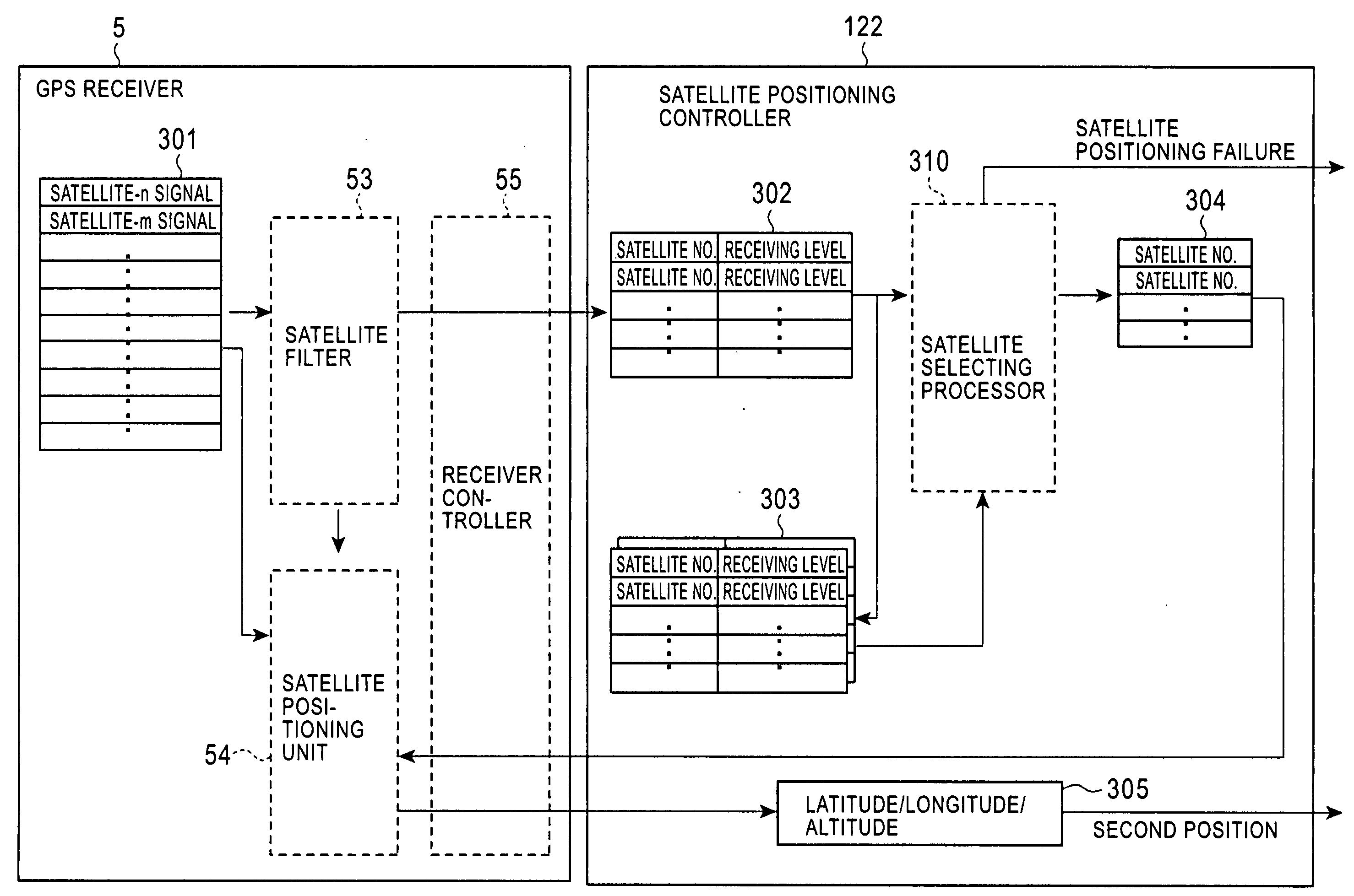
[0010] In the satellite positioning apparatus, when a combination of satellites is continuously available for satellite positioning, this combination of satellites can continuously be used for satellite positioning. Thus, satellite positioning using the same combination of satellites with priority can be realized, leading to stable satellite positioning while suppressing frequent changes of the combination of designated satellites.
[0012] In the satellite positioning apparatus according to a preferred embodiment, satellites to be used for satellite positioning each time may be selected from satellites stably available for satellite positioning for a predetermined period of time or longer up to now so that the combination of satellites to be used for the satellite positioning each time can be as similar as possible to the combination of satellites used for satellite positioning the previous time. It is highly probable that the satellites stably available for satellite positioning for a predetermined period of time or longer up to now will also be stably available for satellite positioning in the future. Therefore, more stable satellite positioning continuously using the same combination of satellites can be realized.
[0015] Thus, even if the number of stably available satellites is three, stable two-dimensional positioning can be performed while suppressing frequent changes of the combination of designated satellites with high probability, which is normally caused by continuous three-dimensional positioning using four or more satellites.
[0016] In the satellite positioning apparatus including the candidate-satellite selecting unit, preferably, the candidate satellites selected by the candidate-satellite selecting unit are satellites that are continuously selected a predetermined number of times or more as the available satellites by the available-satellite selecting unit each time satellite positioning is performed and that have a variation level of signal receiving intensity for a most recent predetermined period of time smaller than a predetermined level. This allows for satellite positioning without multipath effects.
[0019] Accordingly, if the number of satellites stably available for satellite positioning for a predetermined period of time or longer is smaller than three, the current position may be determined based on self-contained-navigation positioning without using satellite positioning. Thus, the current position can be stably determined while preventing a satellite positioning error due to frequent changes of the combination of satellites used for satellite positioning from affecting determination of the current position.

Problems solved by technology

Frequent changes of the satellites used for positioning can deteriorate the positioning stability of satellite navigation, and can cause position jumps or positioning errors.
Such position jumps or positioning errors make it difficult to correct the position determined by the satellite navigation apparatus to a correct position using a correction technique, e.g., map matching between a trajectory defined by determined position records and a road map view.

Method used


Image

  • Satellite positioning apparatus and method
  • Satellite positioning apparatus and method
  • Satellite positioning apparatus and method

Examples


Embodiment Construction

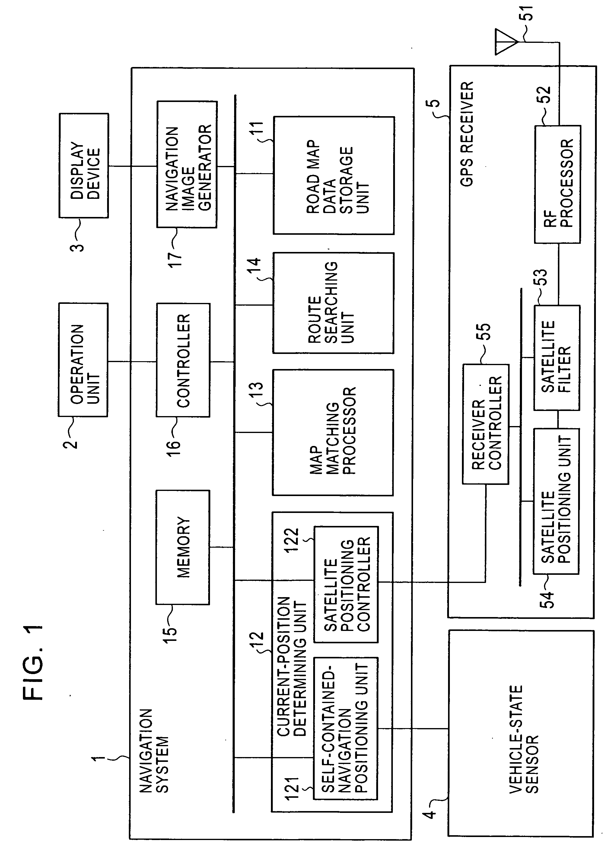
[0026]FIG. 1 is a block diagram of an in-vehicle navigation system according to an embodiment of the present invention.

[0027] The navigation system includes a navigation apparatus 1, an operation unit 2, a display device 3, a vehicle-state sensor 4, and a GPS receiver 5. The vehicle-state sensor 4 is composed of a group of sensors for detecting the vehicle state, including a direction sensor, such as an angular acceleration sensor or a geomagnetic sensor, and a vehicle speed sensor, such as a vehicle speed pulse sensor.

[0028] The navigation apparatus 1 includes a road map data storage unit 11 that is a storage device, such as a digital versatile disk (DVD) drive or a hard disk drive (HDD), storing road map data, a current-position determining unit 12, a map matching processor 13, a route searching unit 14, a memory 15, a controller 16, and a navigation image generator 17.

[0029] The current-position determining unit 12 includes a self-contained-navigation positioning unit 121 that...


PUM


Abstract

Available-satellite data indicating satellites available for satellite positioning is obtained from a GPS receiver, and satellites continuously available for satellite positioning in the current instance and the previous n times are extracted as candidate satellites referring to available-satellite record data. Four of the candidate satellites are selected so that the satellites used for satellite positioning the previous time are selected with priority as the satellites to be used for satellite positioning in the current instance, and the selected satellites are set in designated-satellite data. The GPS receiver performs three-dimensional positioning using the four satellites designated by the designated-satellite data. If the number of extracted candidate satellites is three, these three extracted candidate satellites are selected as the designated satellites and are set in the designated-satellite data. The GPS receiver performs two-dimensional positioning using these three designated satellites. If the number of extracted candidate satellites is smaller than three, satellite positioning is not performed.

Description

BACKGROUND OF THE INVENTION [0001] 1. Field of the Invention [0002] The present invention relates to a satellite positioning apparatus for use in a satellite positioning system, such as the global positioning system (GPS), for determining the position of the apparatus based on signals received from satellites. [0003] 2. Description of the Related Art [0004] GPS is a well-known satellite navigation system including a plurality of satellites and a satellite positioning apparatus that moves along with a mobile object, e.g., a vehicle. [0005] One known positioning technique for use in GPS receivers serving as such GPS satellite positioning apparatuses is positioning with the use of only signals received from high-elevation satellites, thereby reducing multipath effects on the positioning accuracy, which are caused by obstacles, such as buildings (see, for example, Japanese Unexamined Patent Application Publication No. 6-281721). [0006] Another known positioning technique for use in GPS ...

Claims


Application Information

Patent Timeline
Patent Type & Authority Applications(United States)
IPC IPC(8): G01S1/00G01C21/00G01S19/14G01S19/28G01S19/49G01S19/50G08G1/0969
CPCG01S19/49G01S19/28
Inventor WAKAMATSU, KOTARO
Owner ALPINE ELECTRONICS INC
Learn More