Transmission of special routes to a navigation device

a technology of special routes and navigation devices, applied in measurement devices, surveying and navigation, instruments, etc., can solve the problems of heavy transport vehicles or trucks not being able to traverse over particular bridges or roads, multiple types of vehicles not being allowed to travel, and narrow roads or inner city streets being blocked

Active Publication Date: 2006-01-19
HARMAN BECKER AUTOMOTIVE SYST
View PDF49 Cites 184 Cited by
  • Summary
  • Abstract
  • Description
  • Claims
  • Application Information

AI Technical Summary

Problems solved by technology

Several types of vehicles may not be allowed to travel on certain routes calculated by the vehicle navigation system.
For example, wide-body trucks may not be able to travel on narrow roads or inner city streets.
Heavy transport vehicles or trucks may not be able to traverse over particular bridges or roads that cannot support the weight of the load being carried by the truck.
In addition, trucks that are taller or carrying a tall load may not be able to fit underneath bridges along a roadway.

Method used


Image

  • Transmission of special routes to a navigation device
  • Transmission of special routes to a navigation device
  • Transmission of special routes to a navigation device

Examples


Embodiment Construction

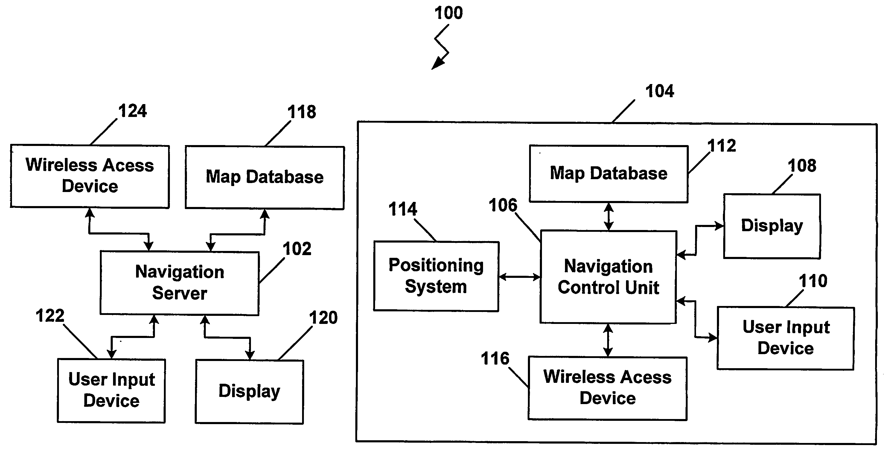
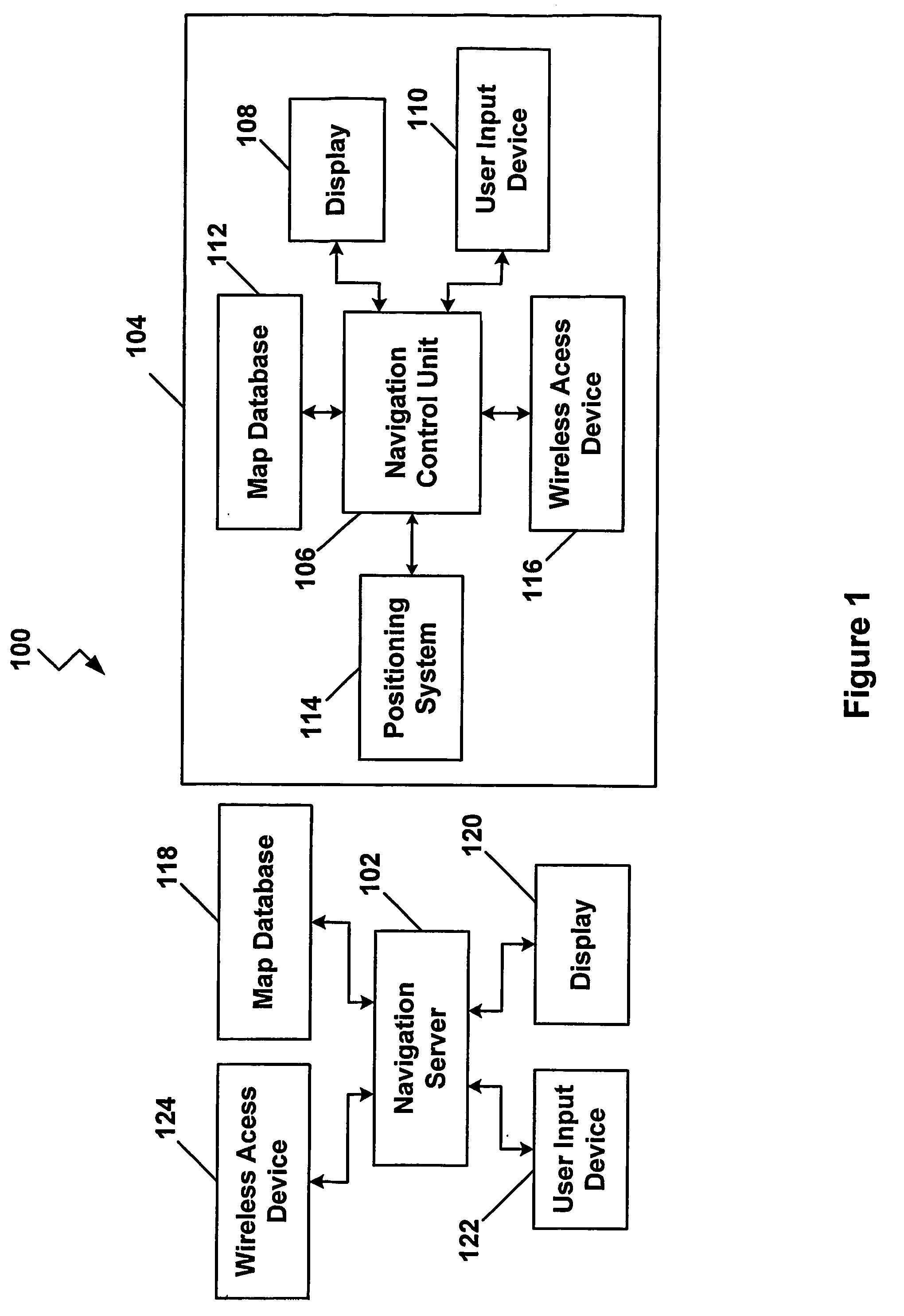
[0027] In FIG. 1, a navigation system 100 with an adapted route calculation module capable of determining special routes as a function of user input preferences is disclosed. As illustrated, the navigation system 100 includes a navigation server 102 and a vehicle navigation system 104. The vehicle navigation system 104 includes a vehicle navigation control unit 106 that, along with the navigation server 102, include software modules programmed to calculate routes from points of origin to predetermined destinations. Although not specifically illustrated, the vehicle navigation control unit 106 may include a Central Processing Unit (“CPU”), a system bus, a Random Access Memory (“RAM”), a Read Only Memory (“ROM”), an I / O adapter for connecting peripheral devices such as hard disc drives, CD-ROM drives, a communications adapter, and a display adapter. Those skilled in the art should recognize that various computing devices may be used as the vehicle navigation control unit 106.

[0028] T...


PUM


Abstract

A vehicle navigation system includes an adaptive routing module (210) that allows a user to provide inputs that influence routes that are calculated to predetermined destinations. A route calculation module (204) executed by a navigation server (102) is operable to calculate a first route from the trip origin to the trip destination. An adaptive route calculation (204) executed by the navigation server (102) is operable to allow the user to enter a user modification of the first route. After the user modification is entered by the user, a second route to the trip destination is calculated as a function of the user modification. The second route is then transmitted to a vehicle navigation system (104).

Description

BACKGROUND OF THE INVENTION [0001] 1. Technical Field [0002] This invention relates generally to vehicle navigation systems and, more particularly, to using special routes in a vehicle navigation system. [0003] 2. Related Art [0004] Vehicle navigation systems are becoming increasingly popular in the automobile industry. A typical vehicle navigation system includes a global positioning system (“GPS”) receiver that is mounted somewhere on the vehicle. The GPS receiver is capable of communicating with a satellite-based global positioning system or other localized positioning systems. The GPS receiver obtains position information that is converted into some form of display for the vehicle operator indicating the position of the vehicle relative to previously determined reference points or other known landmarks on a given map database. [0005] The typical vehicle navigation system also includes a digital map database module that includes digitized map information that can be processed by ...

Claims


Application Information

Patent Timeline
Patent Type & Authority Applications(United States)
IPC IPC(8): G01C21/32G01C21/20G01C21/34G01C21/36G08G1/0968
CPCG01C21/3415G01C21/343G08G1/096872G08G1/096838G08G1/096866G08G1/096811
Inventor GIESEKE, ARNOLD
Owner HARMAN BECKER AUTOMOTIVE SYST
Why Eureka
Try Eureka