Synoptic broad-area remote-sensing via multiple telescopes

a broad-area, multi-telescope technology, applied in the field of remote sensing, can solve the problems of large area coverage, high cost of airborne remote sensors, and limited coverage of sensing systems, and achieve the effect of large area coverage, high acuity, and effective creation of a large virtual array

Inactive Publication Date: 2007-08-16
THE BOEING CO
View PDF13 Cites 42 Cited by
  • Summary
  • Abstract
  • Description
  • Claims
  • Application Information

AI Technical Summary

Benefits of technology

[0006] In an exemplary embodiment, the present invention provides a sensing system capable of both large area coverage and high acuity multi-spectral sensing in a single pass. An exemplary embodiment of a system in accordance with the present invention includes multiple optical telescope assemblies, preferably mounted with fixed location and orientation to an airborne platform. Each telescope assembly includes a linear multi-spectral time delay integrated (TDI) detector array. Image processing stitches the images captured by each telescope assembly, with alignment compensation, to thereby effectively create one large virtual array. The resultant product can be stored and / or disseminated to remotely located users.
[0007] In an exemplary embodiment for high altitude observing platforms, the resultant sweep width can be 100 nautical miles or more. Depending on platform speed (e.g., 100 Knots to hypersonic), a system in accordance with the present invention can provide synoptic coverage of small and medium countries in tens of minutes to hours, and could provide the basis for change detection over wide urban areas with fast revisit rates.
[0010] The present invention provides a base sensor source that can serve multiple purposes, including, for example: providing a metric base source for commercial and non-commercial remote sensing; providing multi-spectral inputs to automatic cueing and discovery algorithms to focus subsequent sensing activities; providing a large map comparison source to detect changes as subsequent sensing data is acquired; providing a synoptic “still” source to allow identification of discrete entities, eliminating miscues such as double counting and miss-association that are common when the map is formed over a long time; and providing an initial map of all activity in a wide area so that a cue arriving at a later time can be paired with pre-existing conditions, thereby enabling derivation of a time history of events.

Problems solved by technology

In general, it is necessary to have a-priori knowledge of what is to be observed in order to observe it, and discovery is often problematic unless one knows where to look.
Conventional overhead remote sensing systems have limited, predictable areas of coverage, whereas conventional high altitude airborne remote sensing systems are typically capable of obtaining only small areas of high acuity sensor data within a reasonable amount of time.
Currently used airborne remote sensors are generally expensive stabilized sight systems that cover very limited swath widths.
Building up a composite sensor picture for an entire area of interest (e.g., a small country) currently takes place over an objectionably long period of time, during which parts of the picture become obsolete due to temporal changes.

Method used


Image

  • Synoptic broad-area remote-sensing via multiple telescopes
  • Synoptic broad-area remote-sensing via multiple telescopes
  • Synoptic broad-area remote-sensing via multiple telescopes

Examples


Embodiment Construction

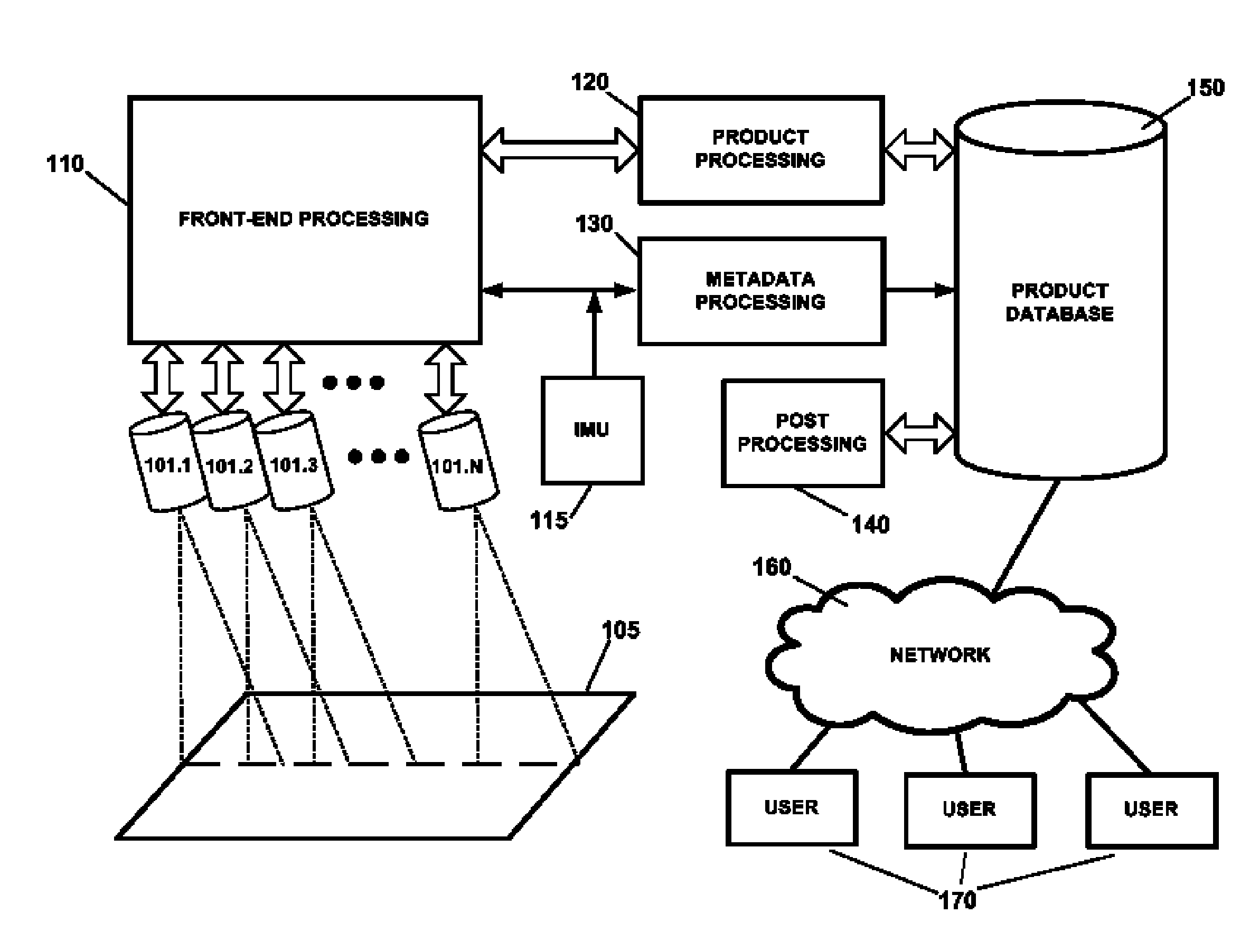
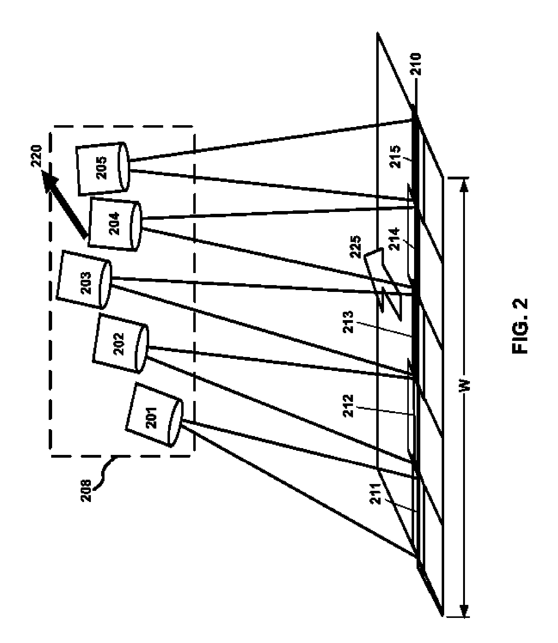
[0018]FIG. 1 is a block diagram illustrating the operation of an exemplary synoptic remote sensing system in accordance with the present invention. The system depicted in FIG. 1 includes a plurality of optical telescopes 101.1-101.N, each of which includes an array of one or more high-resolution detectors. As described in greater detail below, the telescopes 101 capture images, preferably multi-spectral, of adjacent patches of ground over-flown by an airborne platform onto which the telescopes are mounted. (The term “airborne” as used herein is not meant to be limited to aircraft but is intended to also refer to spacecraft or any other vehicle capable of deployment above the earth's surface.)

[0019] The detectors of the telescopes 101 are coupled to a front-end processing block 110 which performs real-time, electronics processing, such as time delay integration (TDI), calibration, data formatting, transfer and storage, and higher-level functions such as array-to-array registration a...


PUM


Abstract

A synoptic, broad-area remote-sensing system using multiple sensors mounted on an airborne platform. Commercially available optical telescopes can be used as the sensors and can be mounted to the platform with fixed location and orientation to collectively view a wide strip of land. Each telescope views a generally linear coverage area which overlaps an adjacent coverage area of another telescope. The images from the coverage areas of the multiple telescopes are stitched in electronic image processing into continuous strips of high-acuity image data. Calibration, distortion correction, alignment and the like are carried out in the electronic image processing using proven, commercially available hardware and software. The image detection for each telescope can be implemented using a linear arrangement of multiple, overlapping linear detectors to yield a wide, high-acuity, virtual field-of-view. The linear detectors can be commercially available detectors with multi-spectral capabilities. A system with large-area synoptic coverage can thus be implemented using low cost, commodity optics and detectors in combination with commercially available image processing hardware and software.

Description

FIELD OF THE INVENTION [0001] The present invention relates to remote sensing, particularly to synoptic broad-area remote-sensing, such as may be performed using an airborne platform. BACKGROUND INFORMATION [0002] Today, remote sensing resources are constrained. In general, it is necessary to have a-priori knowledge of what is to be observed in order to observe it, and discovery is often problematic unless one knows where to look. Conventional overhead remote sensing systems have limited, predictable areas of coverage, whereas conventional high altitude airborne remote sensing systems are typically capable of obtaining only small areas of high acuity sensor data within a reasonable amount of time. Currently used airborne remote sensors are generally expensive stabilized sight systems that cover very limited swath widths. Building up a composite sensor picture for an entire area of interest (e.g., a small country) currently takes place over an objectionably long period of time, durin...

Claims


Application Information

Patent Timeline
Patent Type & Authority Applications(United States)
IPC IPC(8): H04N7/18
CPCG02B23/06G01C11/025
Inventor MICOTTO, MICHAEL V.DAMBRA, LAWRENCE L.
Owner THE BOEING CO
Why Eureka
Try Eureka