Method of processing geological data

Active Publication Date: 2008-10-02
ROXAR SOFTWARE SOLUTIONS
View PDF5 Cites 21 Cited by
  • Summary
  • Abstract
  • Description
  • Claims
  • Application Information

AI Technical Summary

Benefits of technology

[0016]An object of the present invention is to provide a method of processing geological data which provid

Problems solved by technology

The data processing software executes a series of one or more matrix computations in order to derive the geological maps, the computations often requiring considerable computation effort.
It is found in practice that such seismically-derived geological maps are not always entirely accurate on account of noise, ambiguity of reflected seismic components, faults in rock layers affecting seismic wave propagation therethrough or reflection thereat which contribute to cause inaccuracies.
The drillers are then confronted with a problem of navigating their well boreholes during drilling.
As elucidated in the foregoing, oil is typically located in relative thin stratigraphic zones which represent a significant technical challenge for the aforesaid drillers to target precisely.
For example, if a target zone has a true horizontal orientation, then the well borehole, when it penetrates into the zone, extends horizontal to remain within the zone.Prior art only provides less accurate techniques for maintaining a well borehol

Method used


Image

  • Method of processing geological data
  • Method of processing geological data
  • Method of processing geological data

Examples


Embodiment Construction

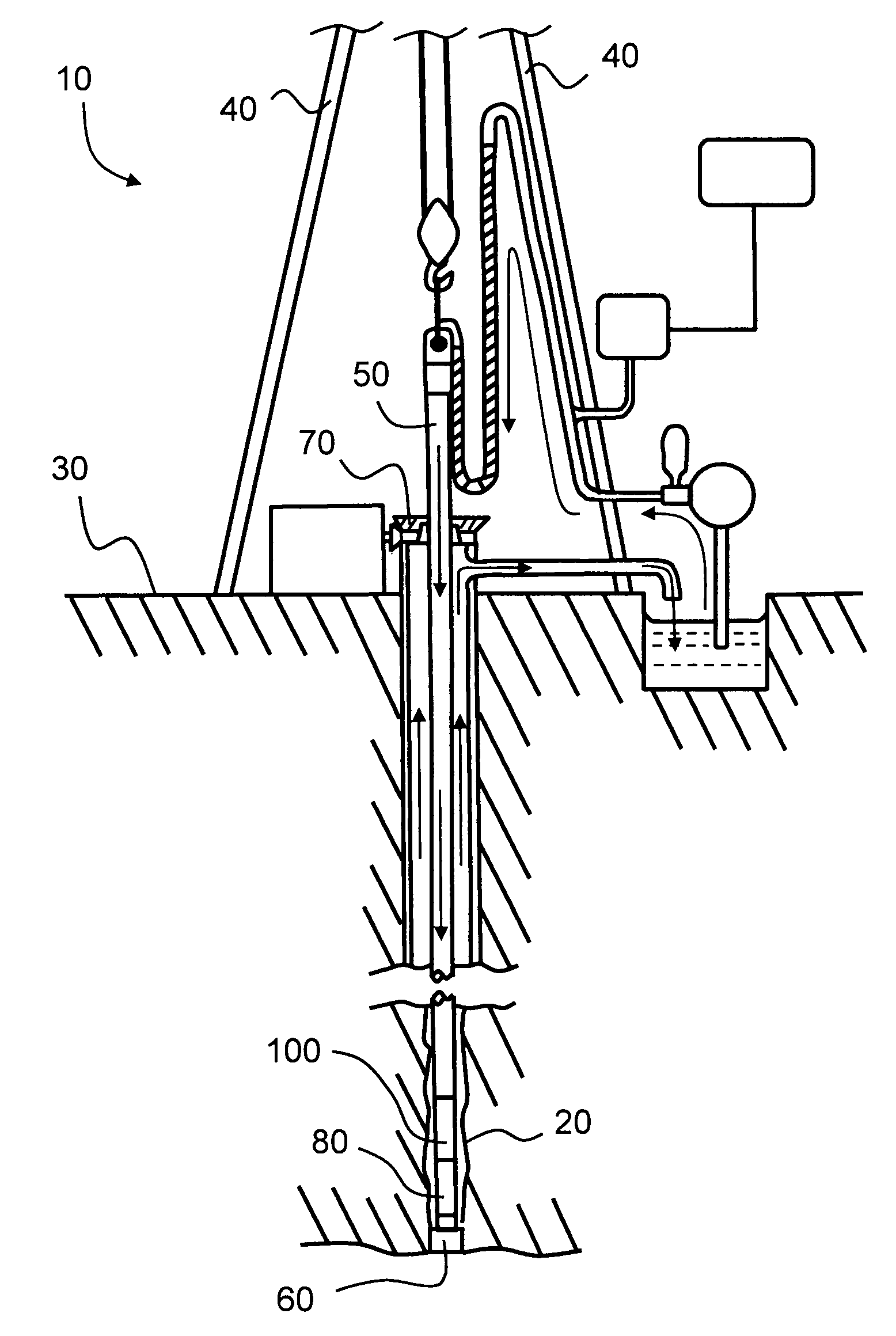
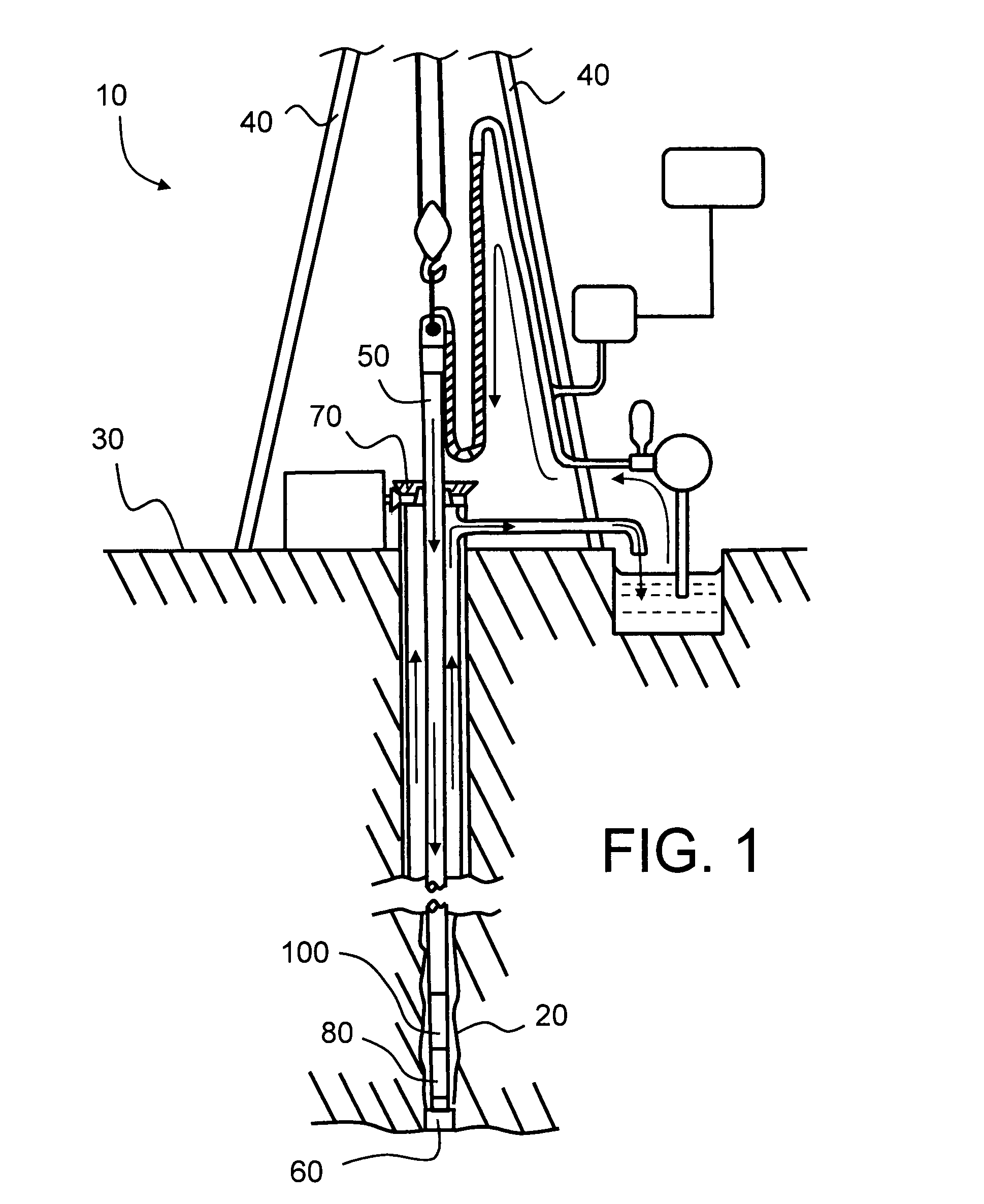
[0049]In overview the present invention is concerned with acquiring an approximate stratigraphic map, most preferably a 3-dimensional stratigraphic map, of a subterranean region, for example by way of seismic metrology, and iteratively improving an accuracy of the stratigraphic map; the accuracy is improved by using information derived from an offset log generated from one or more sensing instruments included along a drilling pipe employed to drill a borehole through the subterranean region.

[0050]Numbers of sections of pipe coupled to form a string of drilling pipes during a process of drilling a borehole are known at various time instances during drilling of the borehole; the overall length of the string of drilling pipes is thereby known. Moreover, by way of one or more inertial navigation units, for example including one or more gyroscopes, included at or near a distal end of the string of drilling pipe in a vicinity of its drill bit enable an angle of the distal end of the strin...


PUM


Abstract

There is provided a method of processing geological data during drilling of a borehole for improving accuracy of the geological data. The method includes a first step of determining from instrumentation (100) associated with a string (50) of drilling pipes a spatial trajectory of a borehole (20, 200) in a subterranean region. A second step of the method involves determining from the spatial trajectory one or more points (P1, P2, P3) with reference to the geological data whereat the trajectory changes direction in one or more layers of strata (F) of the subterranean region. A third step of the method involves subdividing an offset log generated by the instrumentation (100) in response to the one or more points (P1, P2, P3) to generate corresponding sections of offset log. A fourth step involves mutually comparing the subdivided sections of offset log to find a condition of best comparison therebetween and thereby generate one or more error terms (E). A fifth step involves, in response to the one or more error terms (E), updating the geological data to improve its accuracy. Beneficially, the method includes a sixth of repeating the second to fifth steps until the one or more error terms (E) are minimized. The method is relevant for a drilling rig (40) to enhance its drilling accuracy into the subterranean region.

Description

FIELD OF THE INVENTION[0001]The present invention relates to methods of processing geological data, for example to improve borehole drilling accuracy. Moreover, the present invention also concerns software executable on computing hardware for executing such methods. Furthermore, the present invention also relates to apparatus which operable to implement such methods by executing such software products on computing hardware.BACKGROUND TO THE INVENTION[0002]Generation of accurate 2-dimensional and 3-dimensional geological maps is essential for contemporary oil exploration in order for personnel such as geologists to identify geological formations which are likely to yield quantities of oil and / or gas which are profitable to extract. Generation of such geological maps is implemented using seismic apparatus. Each seismic apparatus comprises one or more seismic transmitters and one or more seismic receivers; optionally, the one or more seismic transmitters are also operable to function a...

Claims


Application Information

Patent Timeline
IPC IPC(8): G01V1/16
CPCE21B47/022G01V1/50G01V2210/667
Inventor THEVOUX-CHABUEL, HUGUES
Owner ROXAR SOFTWARE SOLUTIONS
Why Eureka
Try Eureka