Attitude estimation using intentional translation of a global navigation satellite system (GNSS) antenna

a global navigation satellite and intentional translation technology, applied in satellite radio beaconing, measurement devices, instruments, etc., can solve the problems of unsuitable transfer alignment (ta) for many commercial applications, and achieve the effect of improving accuracy, improving accuracy, and improving accuracy of motion or attitude estimation

Active Publication Date: 2009-12-03
WALDOAIR CORP
View PDF28 Cites 49 Cited by
  • Summary
  • Abstract
  • Description
  • Claims
  • Application Information

AI Technical Summary

Benefits of technology

[0019]The motion sensing devices may be coupled to the rigid body via the translation device, and the antenna and motion sensing devices thus experience the same motion. The translating device may be configured to provide knowledge or measurement of motion imparted to the antenna and motion sensing devices, and the processor may use the knowledge or measurement to provide the motion or attitude estimates with improved accuracy relative to not using the knowledge or measurement.
[0020]The motion sensing devices may be mounted to the rigid body independent from the translating device. The tran...

Problems solved by technology

The need to maintain persistent changing velocity to enable attitude measurement and the traditional high co...

Method used


Image

  • Attitude estimation using intentional translation of a global navigation satellite system (GNSS) antenna
  • Attitude estimation using intentional translation of a global navigation satellite system (GNSS) antenna
  • Attitude estimation using intentional translation of a global navigation satellite system (GNSS) antenna

Examples


Embodiment Construction

[0034]A description of example embodiments of the invention follows.

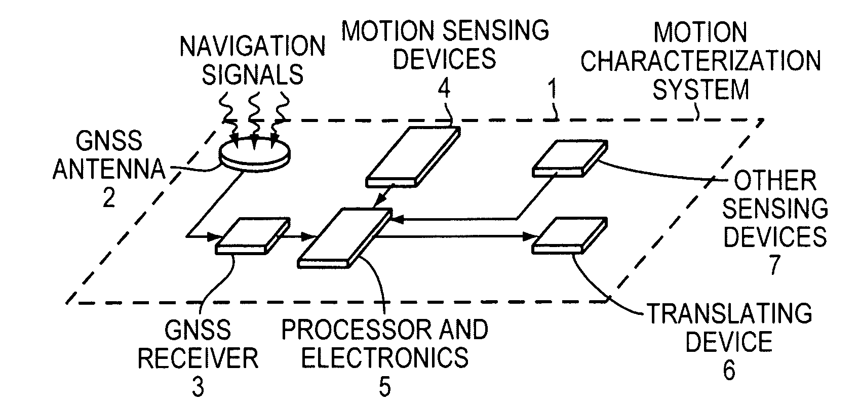
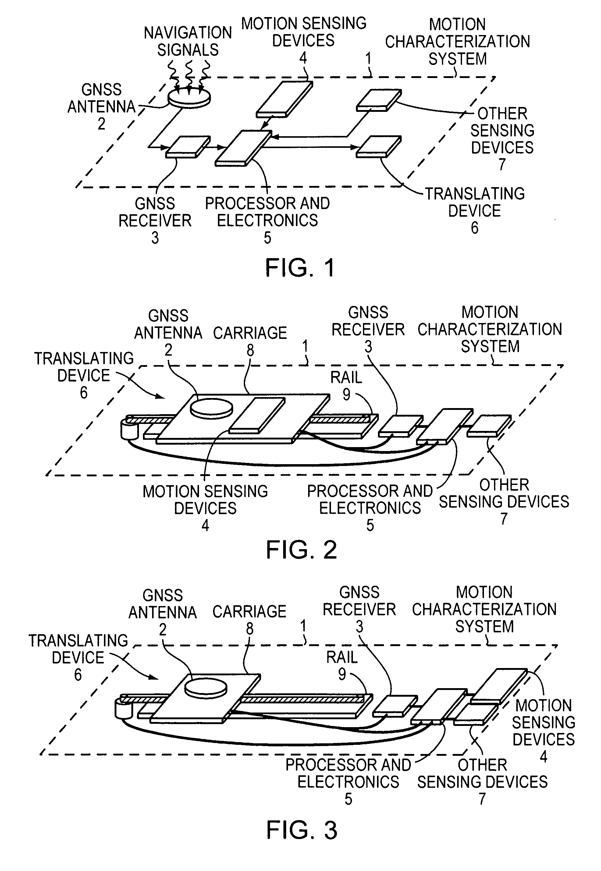
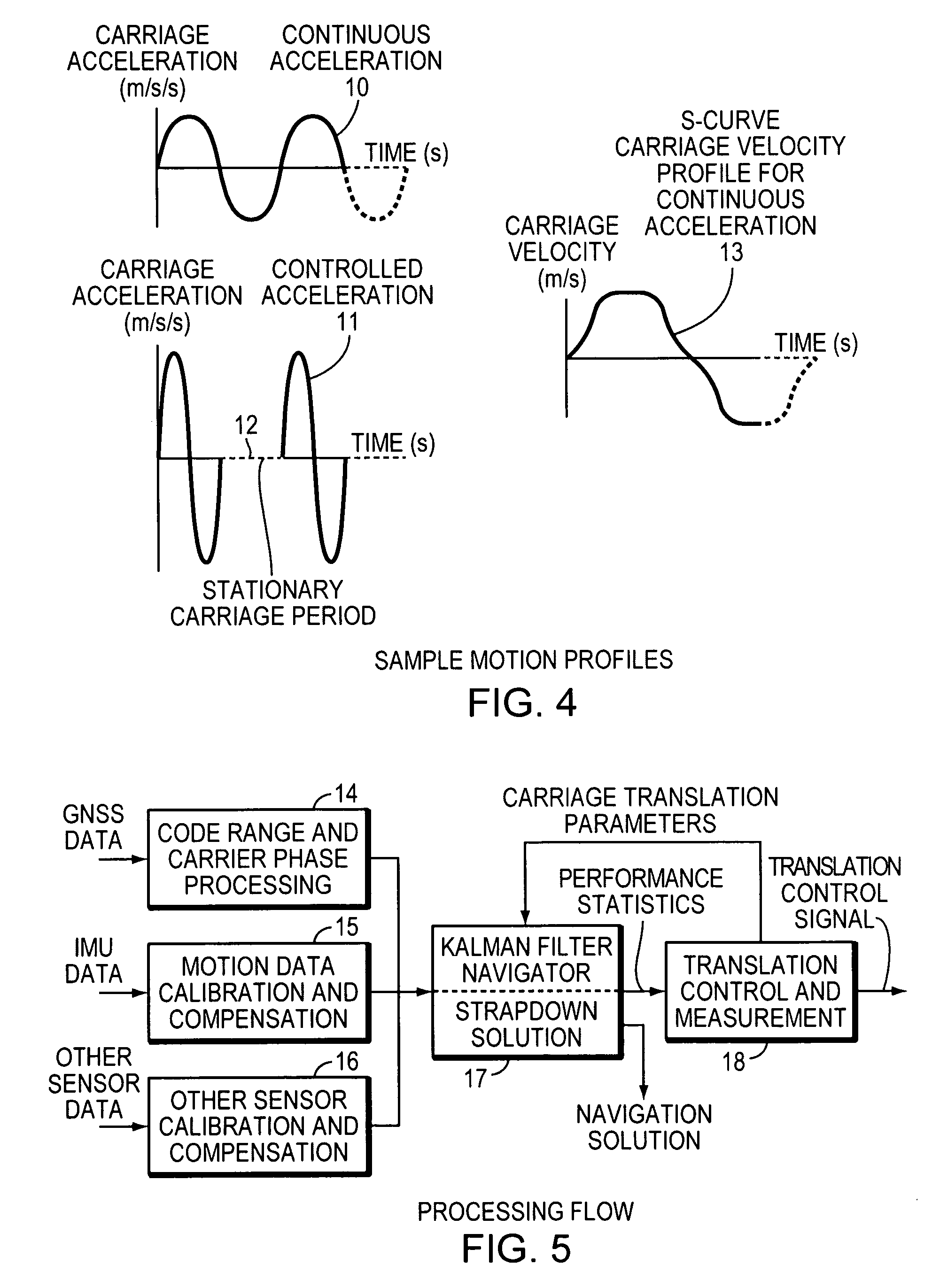
[0035]Mobile vehicle navigations systems, online maps and imagery, and broadband satellite communications from mobile platforms each contribute to the explosive growth in the demand for data. Many systems for data collection or data access can only operate with adequate knowledge of the three-dimensional attitude of the platform used for mounting the system. Both existing and emerging data collection and delivery systems place stringent requirements on antenna pointing accuracy for satellite communications and camera pointing accuracy for geospatial data collection, as examples. While user equipment for fixed gateways can use traditional approaches, user equipment for mobile vehicles, including air vehicles and ground vehicles, demands more innovative solutions.

[0036]Example embodiments of the present invention facilitate data collection and high-speed data access by providing improved attitude estimation performanc...


PUM


Abstract

A system determines three-dimensional attitude of a stationary or moving platform using signals from a Global Navigation Satellite System (GNSS) antenna that undergoes deliberate translation, which may be occasional. The system uses single GNSS receiver, a single GNSS antenna, and inertial acceleration and/or rotation rate sensors. In one implementation, the GNSS antenna and inertial sensing components are rigidly connected and mounted to a pallet that is intentionally translated along a track as needed. In a second implementation, the GNSS antenna is mounted to a pallet, and the inertial sensing components are fixed in position. To maximize effectiveness, the track is oriented along a geometrical direction of the platform that is predominantly in a lateral direction from the gravity vector. The system achieves three-dimensional attitude accuracy that rivals interferometric GNSS systems.

Description

BACKGROUND OF THE INVENTION[0001]Moving platforms include either vehicles such as aircraft, ground vehicles, boats, and spacecraft, or equipment, such as directional antennas, cameras, or turrets, that can be mounted to vehicles and reoriented relative to the vehicle body. The platforms may be traveling at fast or slow speeds, may be maneuvering or non-maneuvering, and may be occasionally stationary relative to geodetic space for time periods of arbitrary lengths. These platforms require knowledge of their geodetic attitude in order, for example, to support safety or stability control systems, to point an antenna, camera, or other sensor boresight at a geodetically known target, to control their geodetic position or attitude movement, or to register the information sensed along the boresight onto a map projection with geodetic coordinates. For the examples, the sensor, camera, or antenna boresight is the centerline of some signal collection or signal transmission aperture.[0002]Eart...

Claims


Application Information

Patent Timeline
IPC IPC(8): G01S5/14
CPCG01S19/54G01S19/47
Inventor PINTO, ROBERT W.KAIN, JAMES E.
Owner WALDOAIR CORP
Why Eureka
Try Eureka