Altimetry method and system

a delay-doppler and altimetry technology, applied in direction finders using radio waves, instruments, reradiation, etc., can solve the problems of complex application of delay-doppler curvature compensation to a paris-like passive bistatic altimetry technique, and requires specific adaptation

Active Publication Date: 2010-01-14
EUROPEAN SPACE AGENCY
View PDF26 Cites 22 Cited by
  • Summary
  • Abstract
  • Description
  • Claims
  • Application Information

AI Technical Summary

Benefits of technology

[0015]According to the invention, such an improvement can be achieved by applying delay-Doppler curvature compensation to passive bistatic altimetry using “opportunity” (e.g. GNSS) signals.

Problems solved by technology

Application of delay-Doppler curvature compensation to a PARIS-like passive bistatic altimetry technique is not straightforward and requires specific adaptation.

Method used


Image

  • Altimetry method and system
  • Altimetry method and system
  • Altimetry method and system

Examples


Embodiment Construction

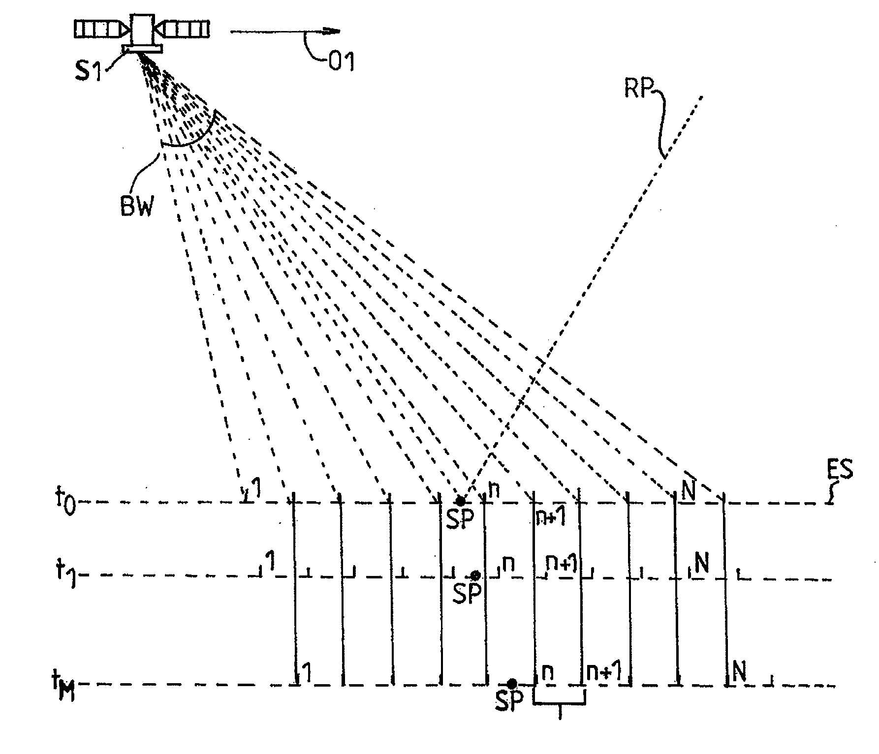
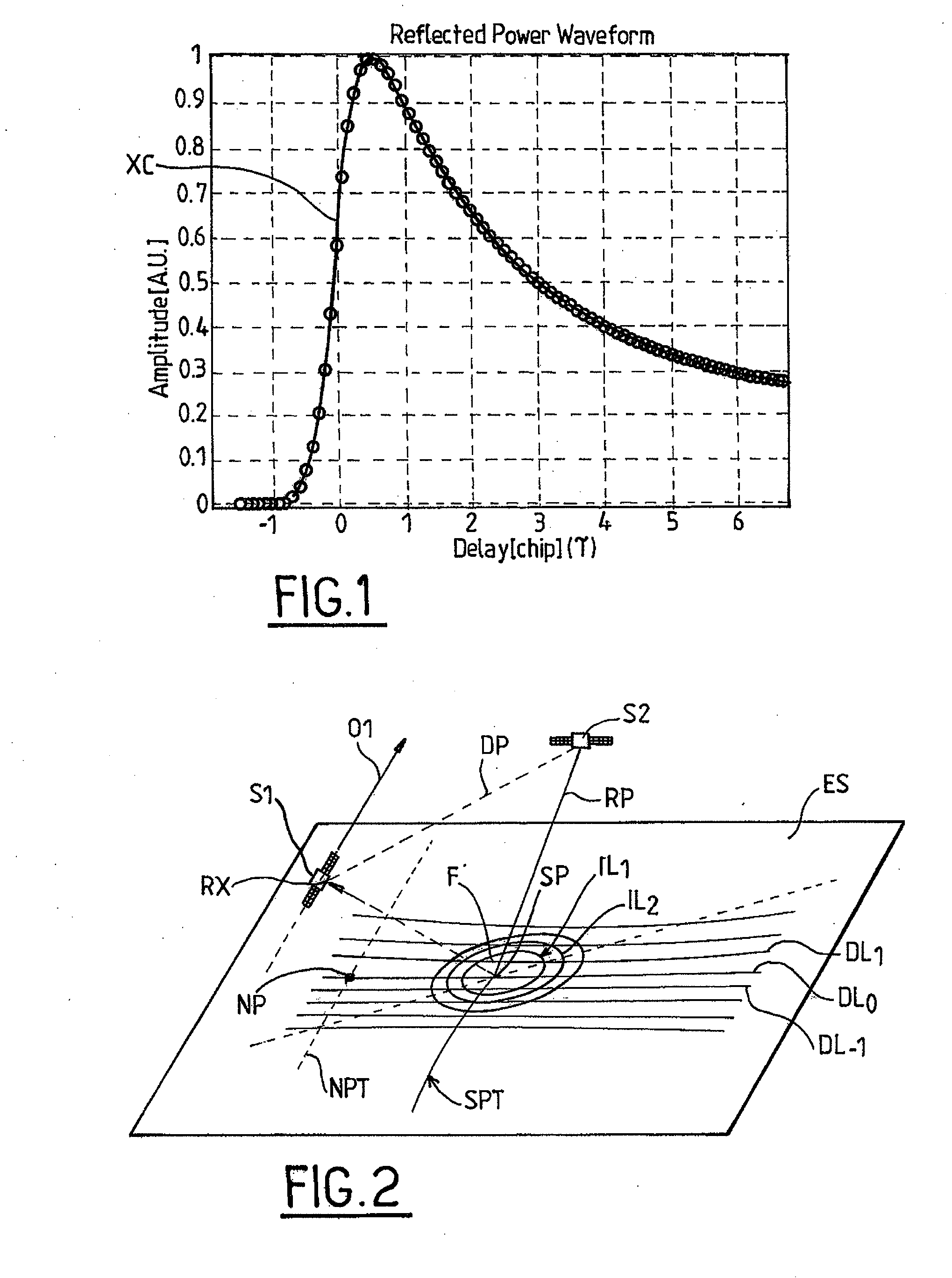
[0033]In order to estimate the height of a target point SP on the surface of the Earth with respect to a reference ellipsoid, a PARIS altimeter computes the cross-correlation of a known replica of the navigation code with the received navigation code pulses reflected / scattered off the surface of the Earth; the target point SP (called specular reflection point) is defined as the point of the Earth surface which reflects specularly the navigation code pulses received by the altimeter. FIG. 1 represents a typical PARIS cross-correlation waveform (XC) for a spread-spectrum GNSS signal such a GPS signal. As in conventional radar altimetry, the distance between the space-borne receiver and the reflecting point on the Earth surface—and therefore the elevation of said reflecting point—is determined by estimating the half power point HP on the rising edge of the waveform XC.

[0034]Indeed, computing the cross-correlation of the reflected GNSS signal with a locally generated replica thereof yie...


PUM


Abstract

An altimetry method comprising: providing a signal receiver (RX) on a first platform (S1) flying above a portion of the Earth surface (ES), for receiving a temporal series of signals emitted by a second flying platform (S2) and scattered by said portion of the Earth surface; and computing altimetry waveforms, indicative of an elevation profile of said portion of the Earth surface, by processing the received signals; characterized in that said step of computing altimetry waveforms comprises: cross-correlating the received signals with a plurality of locally-generated frequency-shifted replicas of the emitted signals; introducing a frequency-dependent temporal shift to the correlation waveforms in order to compensate for range delay curvature; and incoherently summing the temporally shifted correlation waveforms (CXC) corresponding to signals scattered by a same region of the Earth surface at different times during motion of said first platform.

Description

FIELD AND BACKGROUND OF THE INVENTION[0001]The invention relates to an altimetry method and system for determining an elevation profile of a portion of the Earth surface. More precisely, the invention relates to a bistatic passive altimetry method, using opportunity signals such as GNSS signals and incorporating delay-doppler curvature compensation.[0002]The invention can be applied, in particular, to the field of satellite altimetry for oceanography.[0003]The possibility to measure with high accuracy the mesoscale ocean topography is of primary importance for oceanographers, meteorologists or climatologists in order to improve the understanding of ocean circulation, ocean bathymetry, eddies, tides and Earth climate models.[0004]Over the last years, conventional radar altimeters have provided huge amount of data, allowing the observation of many ocean features. However, since they are based on observing the ocean on a small footprint along nadir-looking direction, classical altimete...

Claims


Application Information

Patent Timeline
Patent Type & Authority Applications(United States)
IPC IPC(8): G01S13/08G01S1/00
CPCG01S13/003G01S13/89G01S13/882G01S13/5242
Inventor D'ADDIO, SALVATORE
Owner EUROPEAN SPACE AGENCY
Why Eureka
Try Eureka