Probabilistic reverse geocoding

Inactive Publication Date: 2010-04-08
TELECOMM SYST INC
View PDF100 Cites 18 Cited by
  • Summary
  • Abstract
  • Description
  • Claims
  • Application Information

AI Technical Summary

Benefits of technology

[0009]In accordance with the principles of the present invention, a method of providing an accurate location to a portable navigation device in a congested area when in an off-route condition comprises obtaining a latest location fix of the user's wireless navigation device, the latest location fix being off-route. A last known on-route location of a user's wireless navigation device is obtained. An elapsed time between the last known on-route loc

Problems solved by technology

However, due to the inherent inaccuracy of a GPS fix, this simplistic approach may locate the user on an incorrect road that is near the user's true location.
Since this occurs w

Method used


Image

  • Probabilistic reverse geocoding
  • Probabilistic reverse geocoding
  • Probabilistic reverse geocoding

Examples


Embodiment Construction

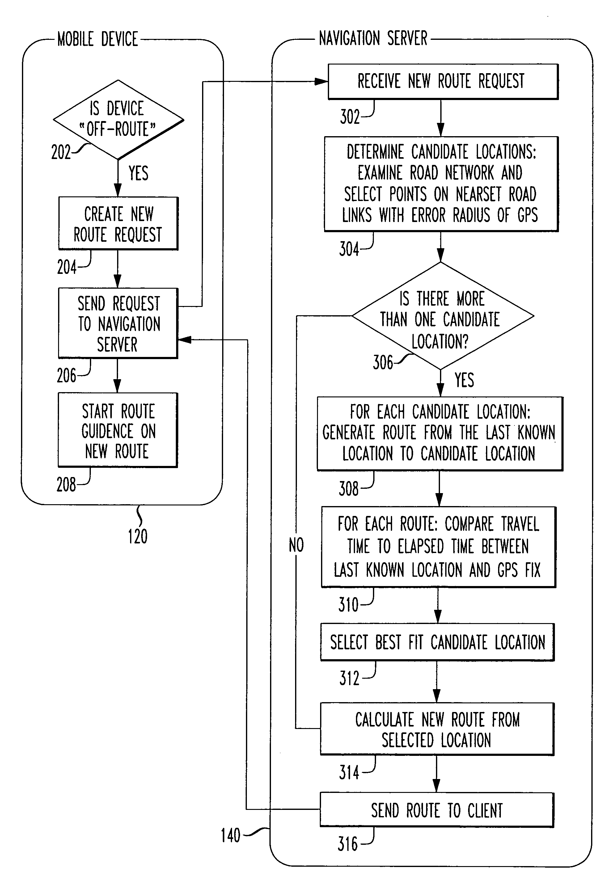
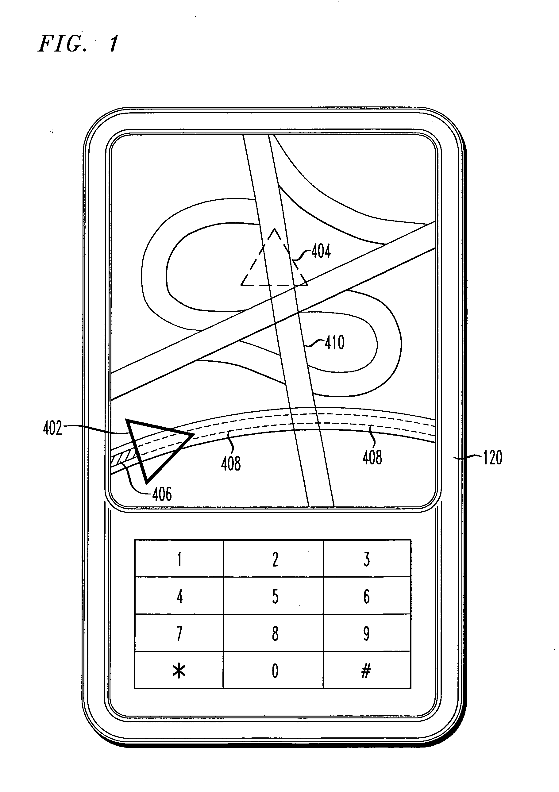
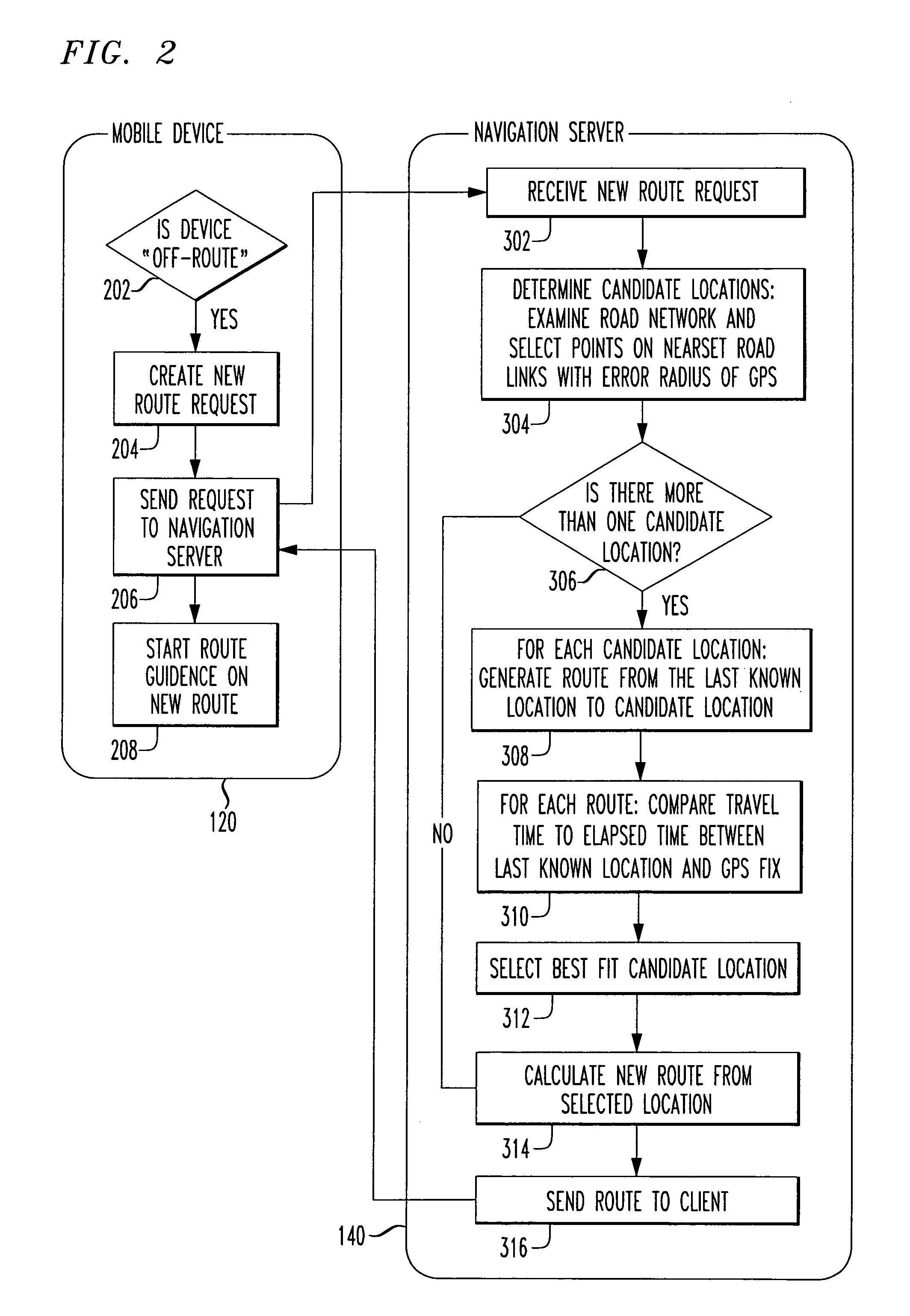
[0016]Car navigation systems typically employ superior GPS technology, gyros and actual vehicle speed to determine a vehicle's current position more accurately. But more recently navigation applications have become available on wireless phones. However, mobile phones don't have access to a directly measured speed of a vehicle as do installed car navigation systems. Moreover, the antenna of a mobile phone may not be in an ideal position as are the antennas for an installed car navigation system. While very good, inaccuracies in the measurement of a current location may lead to an erroneous mapping onto a road in a mobile phone navigation application, particularly in areas where many roads intersect. In a worse case, such inaccuracies can result in mapping of a vehicle on a wrong road.

[0017]The present inventors have discovered that the accuracy of a reverse geocode can be improved significantly by considering together the user's last known location on the original route, the elapsed ...


PUM


Abstract

The accuracy of a reverse geocode for a GPS fix in a mobile phone navigation device is improved significantly by considering together the user's last known location on an original route, the elapsed time between the last known location on the original route and the latest GPS fix, and the likelihood that the user could have traveled from the last known location on the original route to one of numerous candidate locations (generated from the reverse geocode) in the elapsed time. The navigation server relies only on a GPS fix, timestamps, and a back-end routing database to provide improved or superior accuracy of reverse geocoding a GPS fix (selection of a point on a road) when a relevant user has deviated from the intended route. The reverse geocoding allows for accurate and functional re-routing capabilities.

Description

[0001]This application claims priority from U.S. Provisional Application No. 61 / 136,805, entitled “Probabilistic Reverse Geocoding” to Barcklay, filed Oct. 6, 2008, the entirety of which is explicitly incorporated herein by reference.BACKGROUND OF THE INVENTION[0002]1. Field of the Invention[0003]This invention relates generally to wireless communication. More particularly it relates to route guidance (navigation) on a mobile wireless device including global positioning satellite (GPS) capability.[0004]2. Background of Related Art[0005]Navigation devices are typically GPS-based electronic systems used in a vehicle to provide a real-time map of the vehicle's current location, together with step-by-step directions to a requested destination.[0006]All navigation devices must handle the condition in which the user deviates (leaves) their intended route. When this condition occurs, the application typically determines the user's current location by “reverse geocoding” the last GPS fix fr...

Claims


Application Information

Patent Timeline
IPC IPC(8): G01C21/36
CPCG01C21/30G01C21/3415G01C21/26G01C21/20G01C21/34
Inventor BARCKLAY, BOBHAHN, JOHNTSURUTOME, KEVIN
Owner TELECOMM SYST INC
Why Eureka
Try Eureka