Navigation data acquisition and signal post-processing

a technology of data acquisition and signal post-processing, applied in satellite radio beaconing, measurement devices, instruments, etc., can solve the problems of high power consumption of portable devices, high cost of non-assisted and assisted receivers, and low power consumption. , to achieve the effect of reducing power consumption

Inactive Publication Date: 2010-10-07
SKY TAGGER
View PDF5 Cites 33 Cited by
  • Summary
  • Abstract
  • Description
  • Claims
  • Application Information

AI Technical Summary

Benefits of technology

[0013]Another advantage of a navigation system embodiment of the present invention is a position fix can be obtained even when the receiver was not operated long enough at the moment.
[0014]A further advantage of a navigation system embodiment of the present invention is a position fix can be obtained even when the receiver was not operated longer than a second.
[0015]A still further advantage of a navigation system embodiment of the present invention is a position fix can be obtained at very little power cost from a battery in a portable unit.
[0016]Another advantage of a navigation system embodiment of the present invention is that a sequence of position fixes can be obtained with very short time intervals between them, which can be in the order of milliseconds, as opposed to one second, typical in conventional devices.

Problems solved by technology

The long times needed to obtain a first position fix in fully autonomous GNSS receivers can consume a substantial amount of battery power in portable devices.
In fact, some assisted-GNSS receivers are so sensitive they can operate indoors and below decks in boats.
In general, both non-assisted and assisted receivers are expensive as they typically require special hardware to do the signal correlation.
Positions are typically calculated once a second, and that may not give enough spatial resolution for fast moving devices and applications.

Method used


Image

  • Navigation data acquisition and signal post-processing
  • Navigation data acquisition and signal post-processing
  • Navigation data acquisition and signal post-processing

Examples


Embodiment Construction

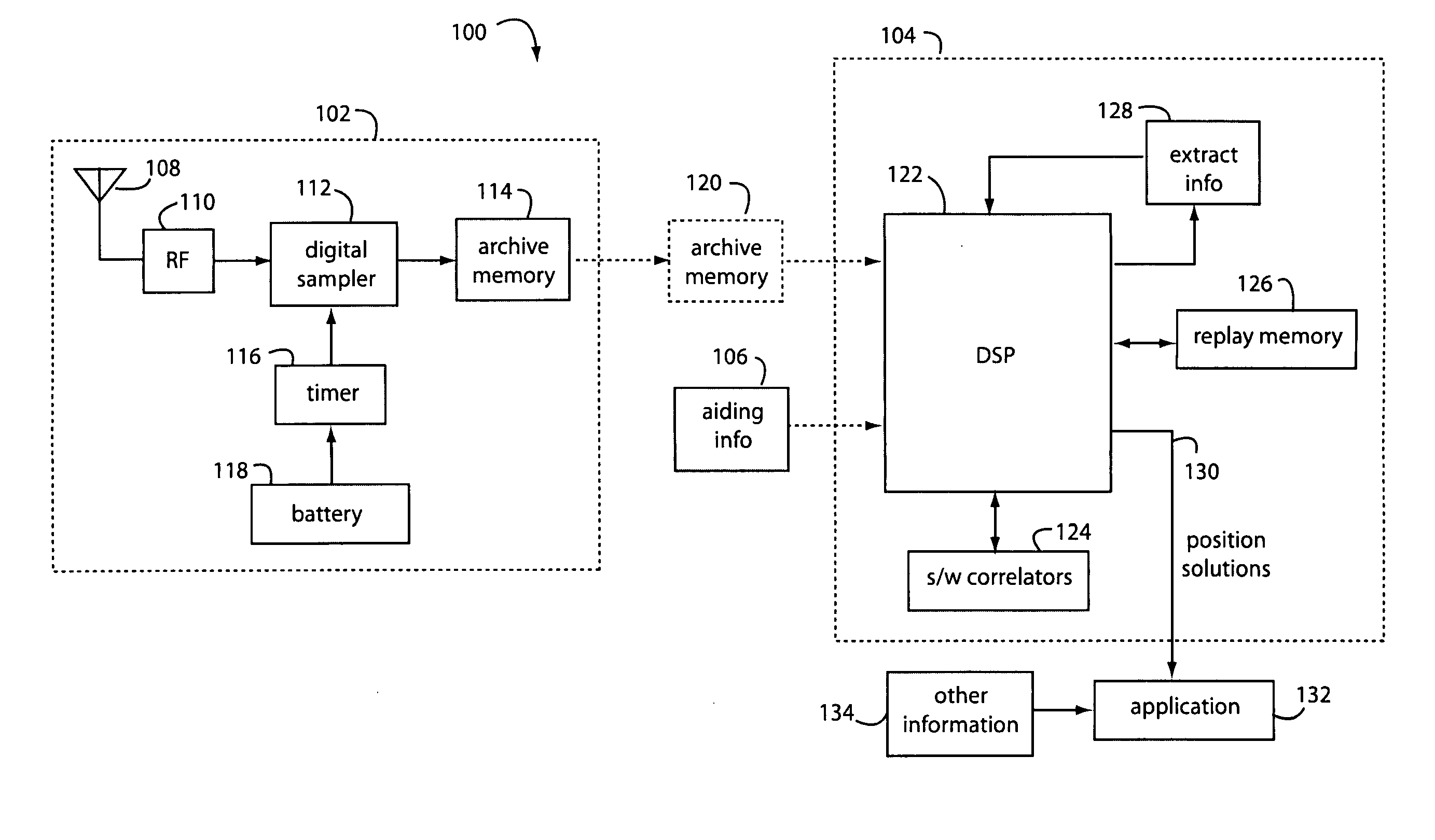
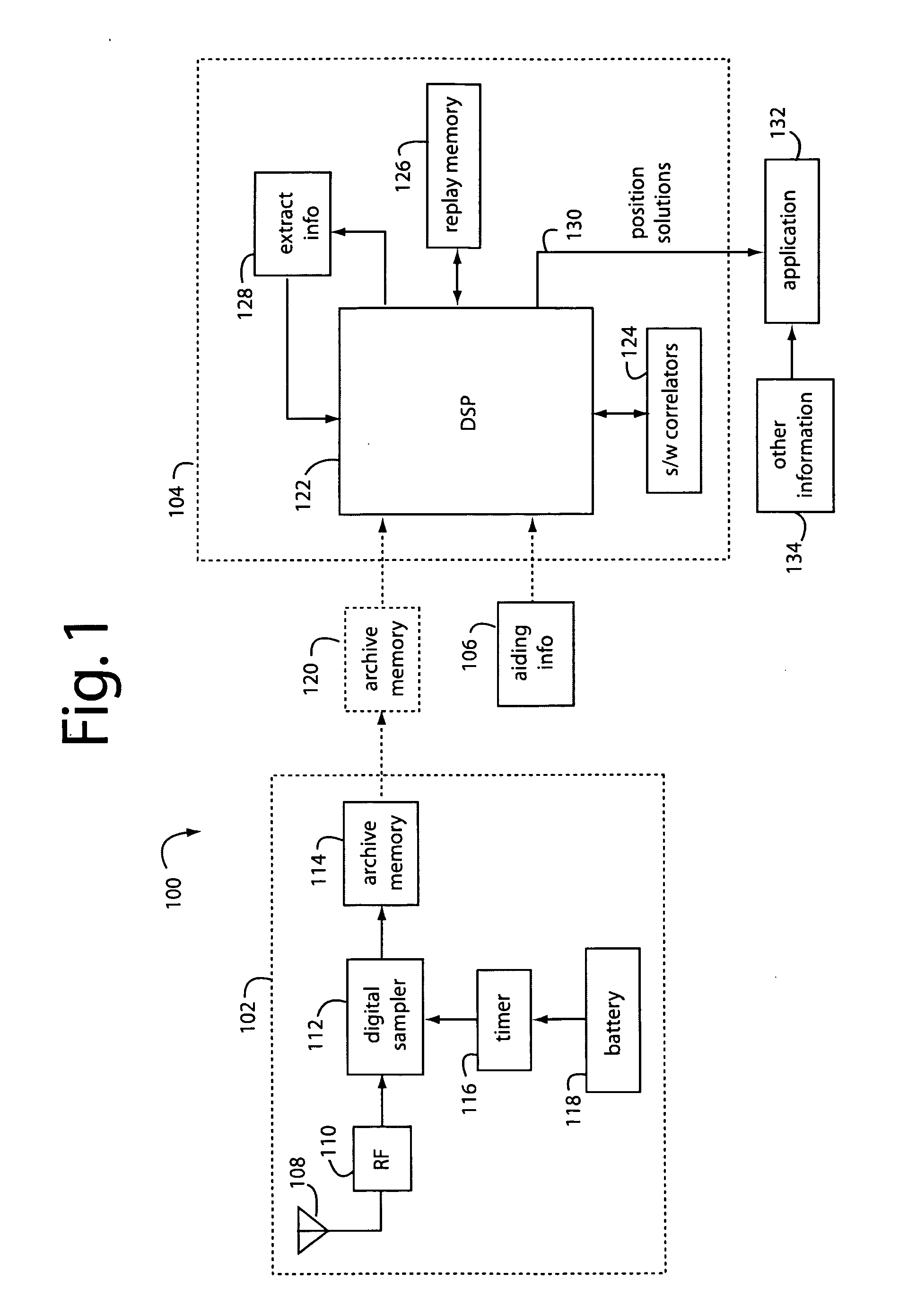
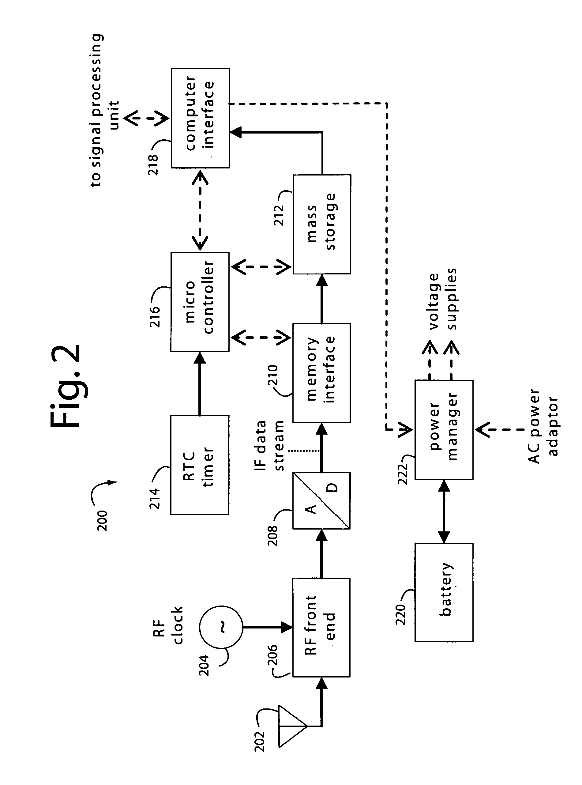
[0022]FIG. 1 represents system embodiment of the present invention, herein referred to by the general reference numeral 100. The system 100 comprises an independent GNSS data acquisition unit 102 that collects raw digitized radio frequency (RF) or intermediate frequency (IF) data sampled from GNSS satellite transmissions. Several GNSS data acquisition units 102 may be used to independently collect GNSS satellite transmissions corresponding to the places and times they were operated, and a single GNSS data acquisition unit 102 may be deployed at different times and to different places if the schedule for that is practical.

[0023]A single post-processor 104, or a number of them, can then be used to respectively batch process the raw digitized RF or IF data samples. It will extract at least the position of the respective GNSS data acquisition unit 102 when it collected the corresponding raw digitized RF or IF data samples. The post-processor 104 can also be used to extract velocity, tim...


PUM


Abstract

A navigation system comprises a radio receiver for the data acquisition of navigation satellite signals, a memory in which to store samples of those signals, and a post-processing unit to replay and signal-process the data in the memory to extract an original position fix for the radio receiver when it acquired the original navigation satellite signals.

Description

RELATED APPLICATIONS[0001]This Application claims benefit of U.S. Provisional Patent Application 60 / 989,945, filed Nov. 25, 2007, titled, GNSS RECEIVER WITH SEPARATE DATA ACQUISITION AND SIGNAL PROCESSING AND RELATED METHODS AND APPARATUS.BACKGROUND OF THE INVENTION[0002]1. Field of the Invention[0003]The present invention relates to navigation satellite systems, and in particular to devices for position solutions in which the data acquisition and signal processing are separated in time and space, and when the position solutions are not needed in real-time and can be batch processed.[0004]2. Description of the Prior Art[0005]Fundamentally, global navigation satellite system (GNSS) receivers are expected to provide a position fix, either described by latitude, longitude and altitude, or by an icon on a map. As a byproduct, GNSS receivers can also provide speed, heading, and very accurate time information. Fully autonomous GNSS receivers, ones without any kind of time, position, Doppl...

Claims


Application Information

Patent Timeline
Patent Type & Authority Applications(United States)
IPC IPC(8): G01S19/36G01S19/37G01S19/38
CPCG01S19/25
Inventor MANTOVANI, JOSE R. B.
Owner SKY TAGGER
Why Eureka
Try Eureka