Incremental map generation, refinement and extension with GPS traces

Active Publication Date: 2012-11-01
TOMTOM GLOBAL CONTENT
View PDF13 Cites 58 Cited by
  • Summary
  • Abstract
  • Description
  • Claims
  • Application Information

AI Technical Summary

Benefits of technology

[0013]By this method, an already existing digital vector map, such as that used for road maps, bicycle maps and footpath maps and the like, can be improved using collected probe data. The improved quality of the digital vector map can be used to more accurately detect branches, merges and crossings in the digital vector map, may be used to generate both unidirectional and bidirectional networks, and represents a substa

Problems solved by technology

Digital maps are expensive to produce and update, since exhibiting and processing road information is very costly.
Furthermore, digital maps are likely to contain inaccuracies or systematic errors due to faulty or inaccurate input sources or flawed inference procedures.
Once a digital map has been created, it is costly to keep map information up to date, since road geometry changes over time.
In some regions of the world, digital maps are not available at all.
ys. As will be appreciated by reference to these figures, in combination with the expense

Method used


Image

  • Incremental map generation, refinement and extension with GPS traces
  • Incremental map generation, refinement and extension with GPS traces
  • Incremental map generation, refinement and extension with GPS traces

Examples


Example

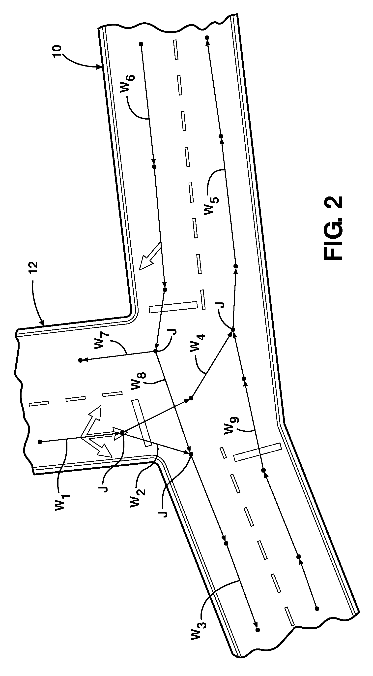
[0023]Referring to the figures, wherein like numerals indicate like or corresponding parts throughout the several views, the subject invention is described schematically in FIG. 4. Here, a plurality of probes 14 are depicted as GPS-enabled personal navigation devices such as those manufactured by TomTom NV (www.tomtom.com). However, any suitable device with GPS functionality may be used to generate probe data points, including handheld devices, mobile phones, PDAs, and the like. The probe data points are collected and stored in a probe data table 16 or other suitable database or repository. The existing digital vector map, in this example a previously created digital map, is contained in a table 18. Of course, the digital vector map 18 can exist as a database or in other suitable form. Trace lines are generated from the rough probe data in table 16 as an initial step. A new line is selected from the probe data table at step 20. The selected line is matched to the digital vector map ...


PUM


Abstract

A method for improving and extending an existing road network and generating new networks from statistically relevant amounts of probe data recorded by GPS-enabled navigation devices. New probe data is matched to the existing digital vector map, then the data merged into the existing network using a weighted mean technique. When new roads are detected, appropriate junction points are made with the existing network elements. The updated network data is simplified to improve computing speed and reduce data storage requirements.

Description

BACKGROUND OF THE INVENTION[0001]1. Field of the Invention[0002]This invention relates generally to a method for updating and extending digital vector maps using probe data, and more particularly toward a method for improving digital roadway and pathway maps using GPS coordinates generated by one or more personal navigation devices.[0003]2. Related Art[0004]Navigation systems, electronic maps (also known as digital maps), and geographical positioning devices are increasingly used by travelers to assist with various navigation functions, such as to determine the overall position and orientation of the traveler and / or vehicle, find destinations and addresses, calculate optimal routes, and provide real-time driving guidance. Typically, the navigation system includes a small display screen or graphic user interface that portrays a network of streets as a series of line segments, including a centre-line running approximately along the centre of each street or path. The traveler can then ...

Claims


Application Information

Patent Timeline
IPC IPC(8): G01C21/32
CPCG09B29/106G01C21/32G01C21/3811G01C21/3844G01C21/3841
Inventor MUND, HEIKO
Owner TOMTOM GLOBAL CONTENT
Why Eureka
Try Eureka