Apparatus and method for providing environmental predictive indicators to emergency response managers

a technology of environmental prediction and indicators, applied in meteorology, instruments, computing, etc., can solve the problems of high probability of danger and/or service outage periods, and achieve the effects of minimizing infrastructure disruption, maximizing personal allocation, and high spatial and temporal correlation factors

Active Publication Date: 2012-11-29
SAINT LOUIS UNIVERSITY
View PDF2 Cites 47 Cited by
  • Summary
  • Abstract
  • Description
  • Claims
  • Application Information

AI Technical Summary

Benefits of technology

[0027]The larger scale numerical weather forecasts from the National Weather Service are combined with the quality controlled high spatial and temporal resolution data from the Mesonet using the model initialization tools produces a significantly improved WRF model initialization that creates a forecast with the highest spatial and temporal correlation factors between observed and forecasted weather data. The high spatial and temporal resolution weather forecast is combined with the location of overhead power lines, and tree density and other natural obstructions or terrain and type to create an index that provides the power industry or other relevant user with an indication of the precise location of threatened areas, when these areas will be affected and for how long. This high spatial and temporal index allows the utility industry to preposition equipment and crews to minimize the disruption to the infrastructure. The advanced warning also allows the utility industry and other entities requiring emergency response management to maximize the allocation of personal. When applying the EAS system to other applications other infrastructure, topography and natural environment features may be used.
[0028]The EAS Process creates accurate, location-specific weather hours ahead of storms, thus users will be better prepared for severe weather. This system is tied to information on trees (and other natural environmental conditions such as for example—terrain and elevation) and power lines (and other infrastructure, such as for example roads or man-made obstructions and structures that can impact the readings of sensor stations or impact of local weather), it also enables users to more readily—and quickly—identify areas that have been hardest hit by outages or damage. Data such as population density, housing density, critical facilities, pedestrian and vehicle traffic can be utilized. This is a more efficient use of financial and human resources and will significantly improve the company's response and restoration time for customers, improving system reliability.

Problems solved by technology

The threat level index is a probabilistic tool that rates areas in which certain infrastructure is likely to encounter certain, possibly hazardous conditions, and / or outages, which can result in a high probability of danger and / or service outage periods.

Method used


Image

  • Apparatus and method for providing environmental predictive indicators to emergency response managers
  • Apparatus and method for providing environmental predictive indicators to emergency response managers
  • Apparatus and method for providing environmental predictive indicators to emergency response managers

Examples


Embodiment Construction

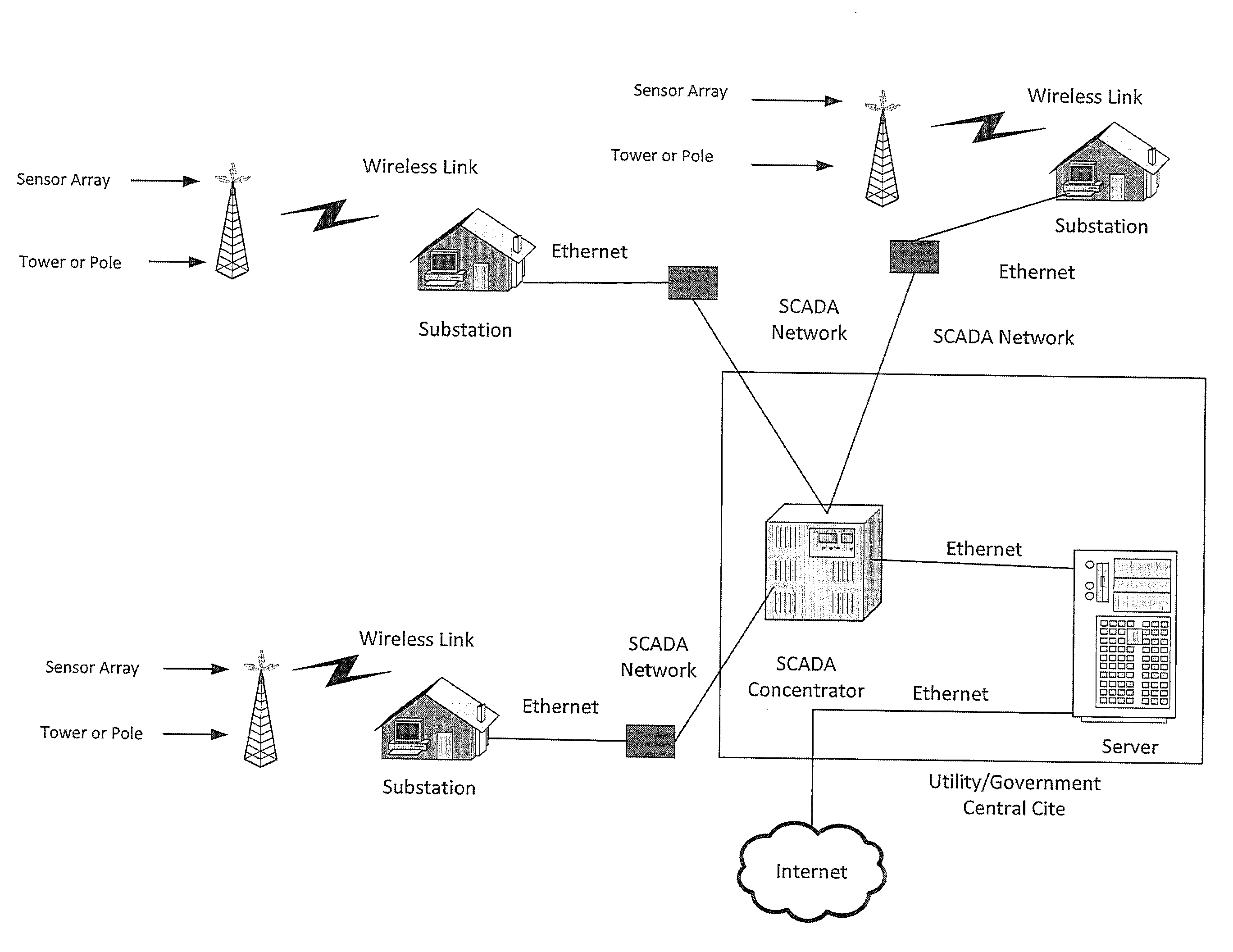
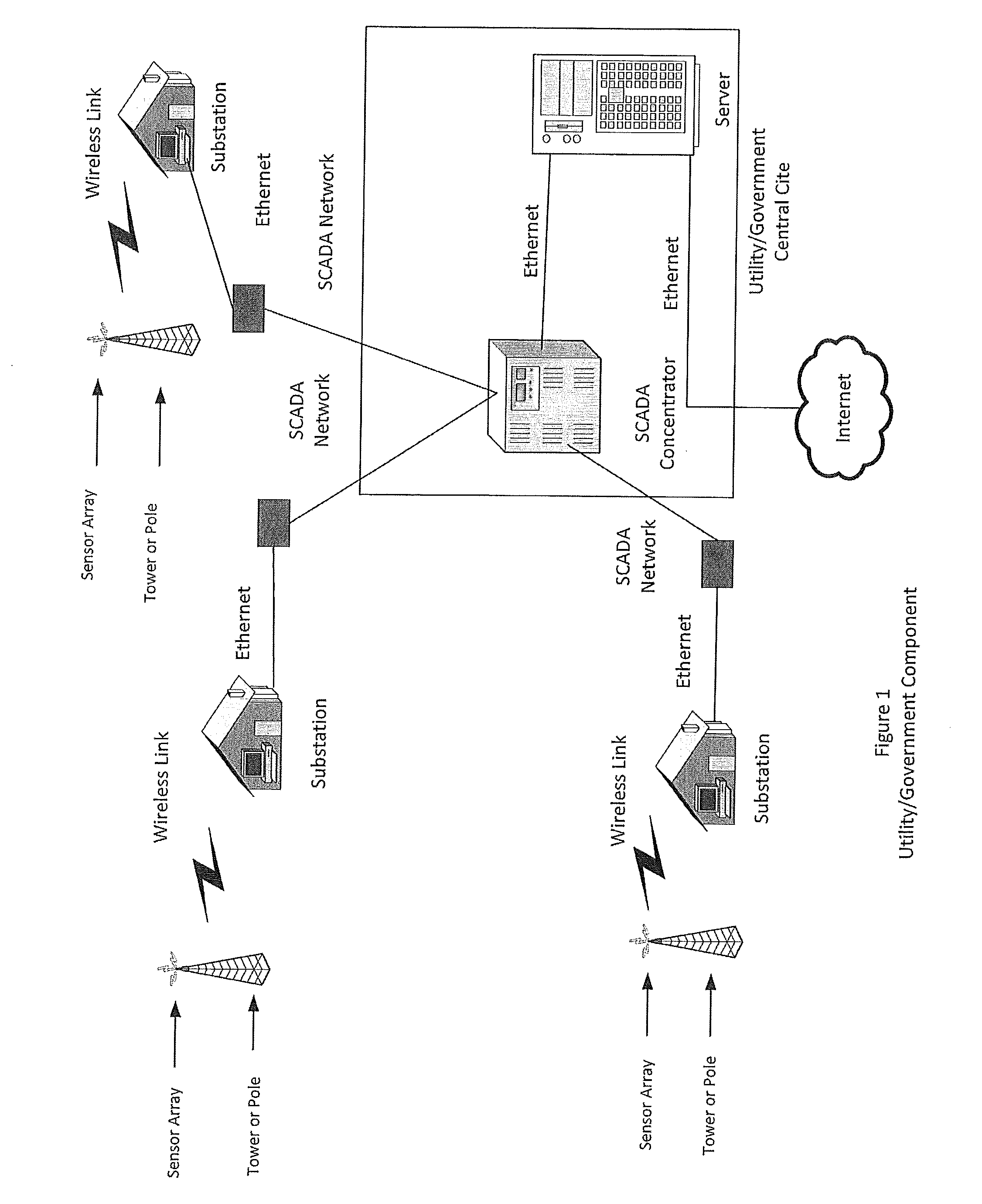
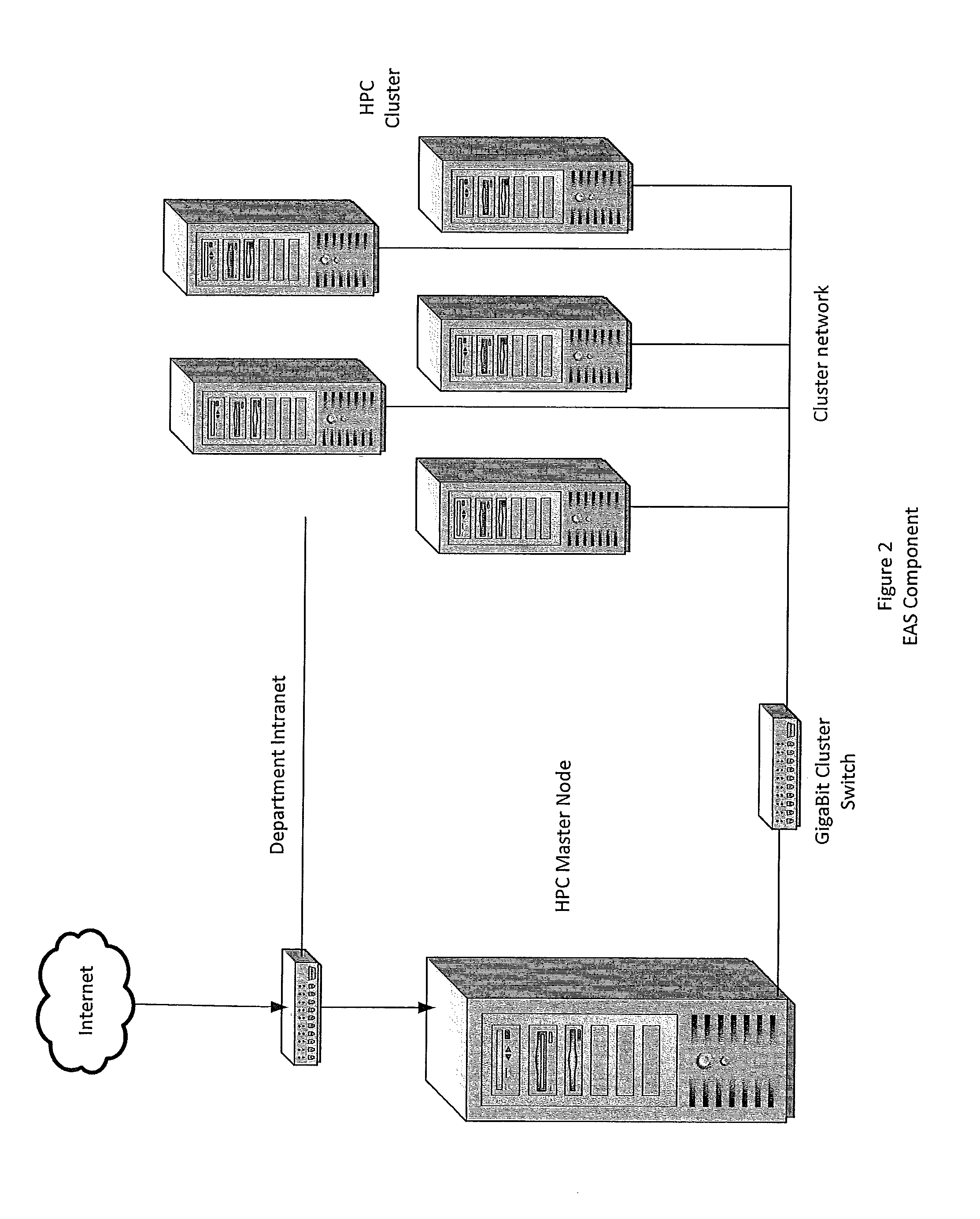
[0045]According to the embodiment(s) of the present invention, various views are illustrated in FIGS. 1-9 and like reference numerals are being used consistently throughout to refer to like and corresponding parts of the invention for all of the various views and figures of the drawing.

[0046]Data from all over the entire globe is typically utilized in order to make a forecast. Meteorological forecasting is performed in a global fashion. Global forecast data is available to forecasters around the world. There is a very large global model referred to as GFS, which stands for the Global Forecast System. Unfortunately, it is difficult to make that model work on a localized level in order to predict weather events accurately because the resolution of the model is very coarse—lacks sufficient resolution. Further, such a forecast system lacks the ability to factor in local parameters that may affect the accuracy of a prediction and further predict the impact that the weather event may caus...


PUM


Abstract

A method of predicting weather-exacerbated threats, said method comprising inputting localized weather measurement data into a weather threat prediction system; predicting future localized weather conditions based on said localized weather measurement data combined with modeling from National Weather Service Data; inputting natural environment and infrastructure data into said weather threat prediction system; correlating said infrastructure data with said predicted future localized weather conditions; and determining a threat level index over a region, a threat level indicating an area having a certain probabilistic likelihood of being harmed by said future weather conditions.

Description

CROSS-REFERENCE TO RELATED APPLICATION[0001]This application is a continuation-in-part application of U.S. Non-Provisional application Ser. No. 12 / 618,012, filed Nov. 13, 2009, entitled APPARATUS AND METHOD FOR PROVIDING ENVIRONMENTAL PREDICTIVE INDICATORS TO EMERGENCY RESPONSE MANAGER, which claims the benefit of and priority to U.S. Provisional Patent Application Ser. No. 61 / 114,357, filed Nov. 13, 2008, entitled SYSTEM AND METHOD FOR PROVIDING ENVIRONMENTAL PREDICTIVE INDICATORS TO EMERGENCY RESPONSE MANAGERS, which aforesaid applications are hereby incorporated by reference in their entirety to the extent permitted by law.BACKGROUND OF INVENTION[0002]1. Field of Invention[0003]The present invention generally relates to systems and methods for providing decision support predictive indicators that will create real-time probability impact information for decision makers and logistical managers when allocating resources and man power responsive to infrastructure repair, emergency ev...

Claims


Application Information

Patent Timeline
Patent Type & Authority Applications(United States)
IPC IPC(8): G01W1/00G06F19/00
CPCG01W1/10G01W1/00
Inventor DANNEVIK, WILLIAMPASKEN, ROBERT W.
Owner SAINT LOUIS UNIVERSITY
Why Eureka
Try Eureka