System and method for localizing a trackee at a location and mapping the location using inertial sensor information

a technology of inertial sensor information and localization method, which is applied in traffic control systems, navigation instruments, instruments, etc., can solve problems such as inability to trust information, continuous decrease in quality, and cumulative errors, and achieve the effect of facilitating longer duration navigation

Active Publication Date: 2013-12-12
TRX SYST
View PDF2 Cites 147 Cited by
  • Summary
  • Abstract
  • Description
  • Claims
  • Application Information

AI Technical Summary

Benefits of technology

[0020]By recognizing the sensor features when revisited, the mapping application may use the sensor features for location correction when implementing SLAM (or other) algorithms, thus enabling longer duration navigation within a location and mapping of the location. The identified sensor features when revisited may be fed back into a location estimate determined during the revisit and the corrected location estimate may be fed back into the map for refining the corresponding location of the landmark on the map.
[0025]According to an aspect of the invention, the detected sensor features may be reported as a feature message that includes individually identifiable feature information along with time / location, which can be associated to a path location (and which can be updated with the path as the path is corrected). The detected sensor features can be recognized when revisited and used for location correction, thus facilitating longer duration navigation.

Problems solved by technology

One problem associated with the derived metric motion information is that, because it involves a dead reckoning process, it is subject to cumulative error.
This may lead to a continuous decrease in quality; therefore, such information may not be trusted over long periods of time.
On the other hand, the quality of feature based map information is stationary over time, but suffers from the perceptual aliasing problem.
However, issues remain in realizing general SLAM solutions in practice and notably in building and using perceptually rich maps as part of a SLAM algorithm.
This is despite the fact that many sensor noise models are not well represented by additive Gaussian noise.
Although conventional cell phone applications include the ability to enhance location using cell carrier location services (such as cell tower triangulation) and Wi-Fi (for example, provided by SKYHOOK and now APPLE, GOOGLE, and others), the location accuracy provided by these applications is not adequate.
However, the data provided by the embedded sensors are typically not the same quality as traditional navigation sensors.
For example, Micro-Electrical-Mechanical System (“MEMS”) sensors are subject to large inertial drift and other errors that should be accounted for in the design and operation of MEMS-based navigation algorithms.

Method used


Image

  • System and method for localizing a trackee at a location and mapping the location using inertial sensor information
  • System and method for localizing a trackee at a location and mapping the location using inertial sensor information
  • System and method for localizing a trackee at a location and mapping the location using inertial sensor information

Examples


Embodiment Construction

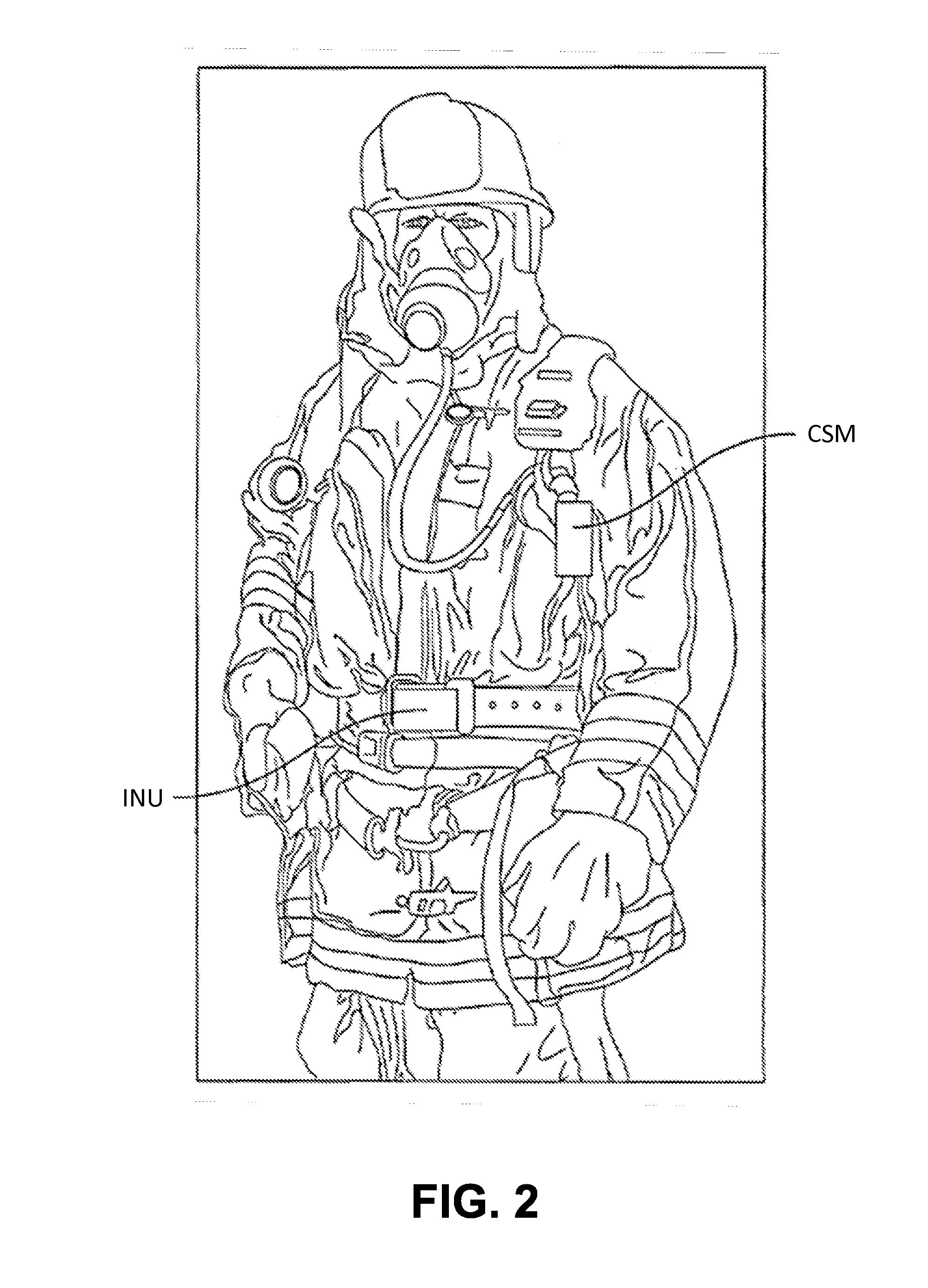
[0062]The invention described herein is directed to systems, computer program products, and methods for both localizing a trackee at a location and mapping the location using sensor information obtained from inertial sensors. By way of background, “personnel,” as used herein, may refer broadly (and without limitation) to living entities (e.g., people, animals, etc.), while “assets” may refer broadly (and without limitation) to objects including, for example, those being moved or controlled by personnel as well as autonomous objects such as robots. A person (or other example of personnel) and an asset may also each be referred to herein more broadly as a “subject,” a “trackee,” a “target,”“a user” or another similar descriptor. In some instances, the mapping application may be referred to interchangeably herein as “mapping software” or “mapping technology.”

[0063]Exemplary System Architecture

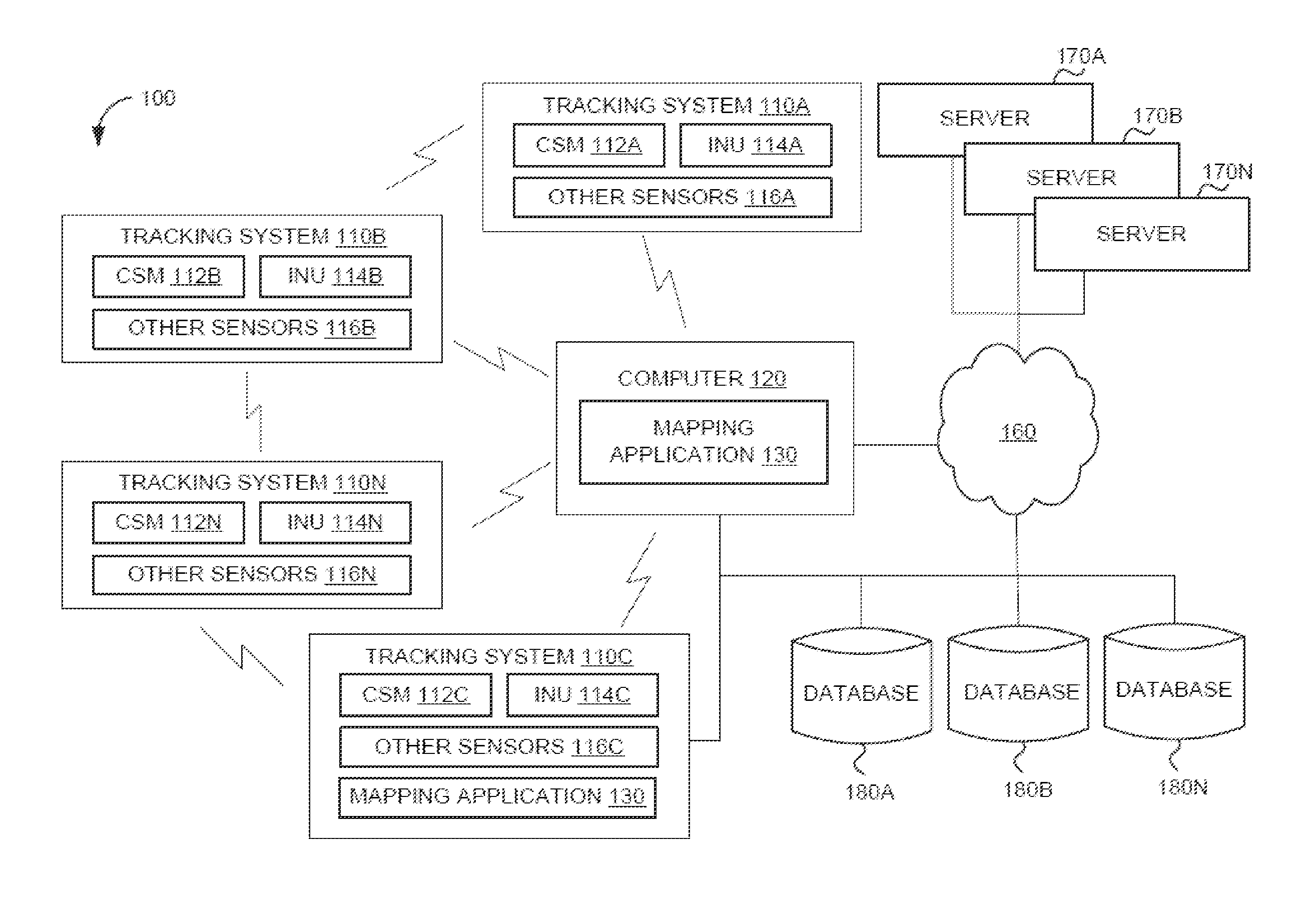
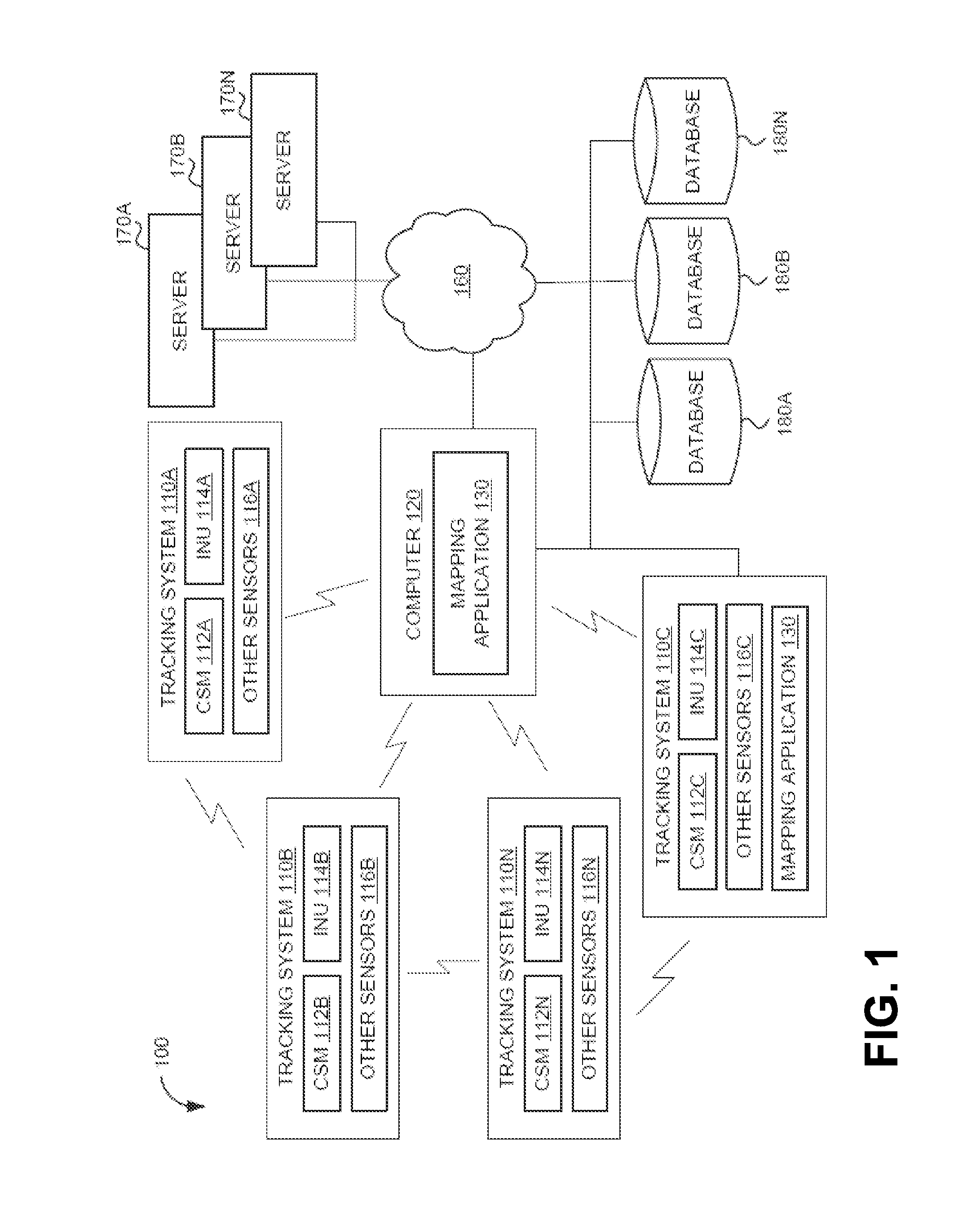
[0064]FIG. 1 depicts an exemplary architecture for a system 100, according to an aspect of the...


PUM


Abstract

A system and method for recognizing features for location correction in Simultaneous Localization And Mapping operations, thus facilitating longer duration navigation, is provided. The system may detect features from magnetic, inertial, GPS, light sensors, and / or other sensors that can be associated with a location and recognized when revisited. Feature detection may be implemented on a generally portable tracking system, which may facilitate the use of higher sample rate data for more precise localization of features, improved tracking when network communications are unavailable, and improved ability of the tracking system to act as a smart standalone positioning system to provide rich input to higher level navigation algorithms / systems. The system may detect a transition from structured (such as indoors, in caves, etc.) to unstructured (such as outdoor) environments and from pedestrian motion to travel in a vehicle. The system may include an integrated self-tracking unit that can localize and self-correct such localizations.

Description

CROSS-REFERENCE TO RELATED APPLICATIONS[0001]This application claims priority to U.S. Provisional Patent Application Ser. No. 61 / 799,659, filed Mar. 15, 2013, and U.S. Provisional Patent Application Ser. No. 61 / 658,697, filed Jun. 12, 2012, both of which are hereby incorporated by reference herein in their entireties.FIELD OF THE INVENTION[0002]The invention relates to systems, computer program products, and methods for both localizing a trackee at a location and mapping the location using sensor information obtained from inertial sensors.BACKGROUND OF THE INVENTION[0003]Generally speaking, a goal of localization and mapping is to compute the most probable location of a trackee using prior sensor and control values (if available). Simultaneous Localization And Mapping (“SLAM”) is a particular localization and mapping technique that uses allothetic sensors, such as image sensors that provide external information about the environment, and idiothetic sensors, which provide information...

Claims


Application Information

Patent Timeline
Patent Type & Authority Applications(United States)
IPC IPC(8): G01C21/20
CPCG01C21/206G01S19/39G01S5/012G01S5/014G01S5/015G01C21/3844G01C21/1652G01C21/3848G01C21/1656G01C21/1654G01S19/13
Inventor FUNK, BENJAMIN E.NAPORA, JAREDKORDARI, KAMIARVERMA, RUCHIKABANDYOPADHYAY, AMRITTEOLIS, CAROLE
Owner TRX SYST
Why Eureka
Try Eureka