Autonomous range-only terrain aided navigation

a technology of autonomous range and terrain, applied in the direction of navigation instruments, instruments, process and machine control, etc., can solve the problems of false correlation, labor-intensive preparation, and conventional radar altimeters do not provide bearing angles to the closest terrain, so as to minimize the differences over the history and improve the accuracy of correction

Active Publication Date: 2016-02-18
RAYTHEON CO
View PDF4 Cites 56 Cited by
  • Summary
  • Abstract
  • Description
  • Claims
  • Application Information

AI Technical Summary

Benefits of technology

[0015]In an embodiment, a post-correlation refinement is made to improve the accuracy of the correction beyond the correlation level. The correlation offset is used to select a correlation history of range predictions and a corresponding three-dimensional range prediction vector. A difference vector between the range measurements and the selected range predictions and line-of-sight unit vectors from the three-dimensional range prediction vector and correlation history of range predictions are computed. The difference vector and the line-of-sight unit vectors are used to compute a three-dimensional offset from the correlation offset that minimizes the differences over the history. The three-dimensional offset is added to the correlation offset to provide a correction to the horizontal position estimate as well as the altitude estimate of the vehicle. The covariance is recalculated to correct the uncertainty as a result of the correlation results.

Problems solved by technology

The main limitation of TERCOM is the labor-intensive preparation to tailor a set of terrain maps for each mission.
Conventional radar altimeters do not provide a bearing angle to the closest terrain.
This can cause false correlations.
This requires detailed analysis of each mission and its associated terrain and limits the flexibility of mission planning.
However, computing this reference map transformation involves a lot of pre-mission work and does not solve the problem that the mission is constrained to a particular clearance height, heading and speed.
A disadvantage is that the sensor and associated processing equipment and algorithms are very complex.
PTAN requires three antennas with a significant special separation to get the full angular information, which limits its use to vehicles that are large enough to accommodate this spacing.
Furthermore, PTAN requires expensive calibration of the boresight angles to a high accuracy.

Method used


Image

  • Autonomous range-only terrain aided navigation
  • Autonomous range-only terrain aided navigation
  • Autonomous range-only terrain aided navigation

Examples


Embodiment Construction

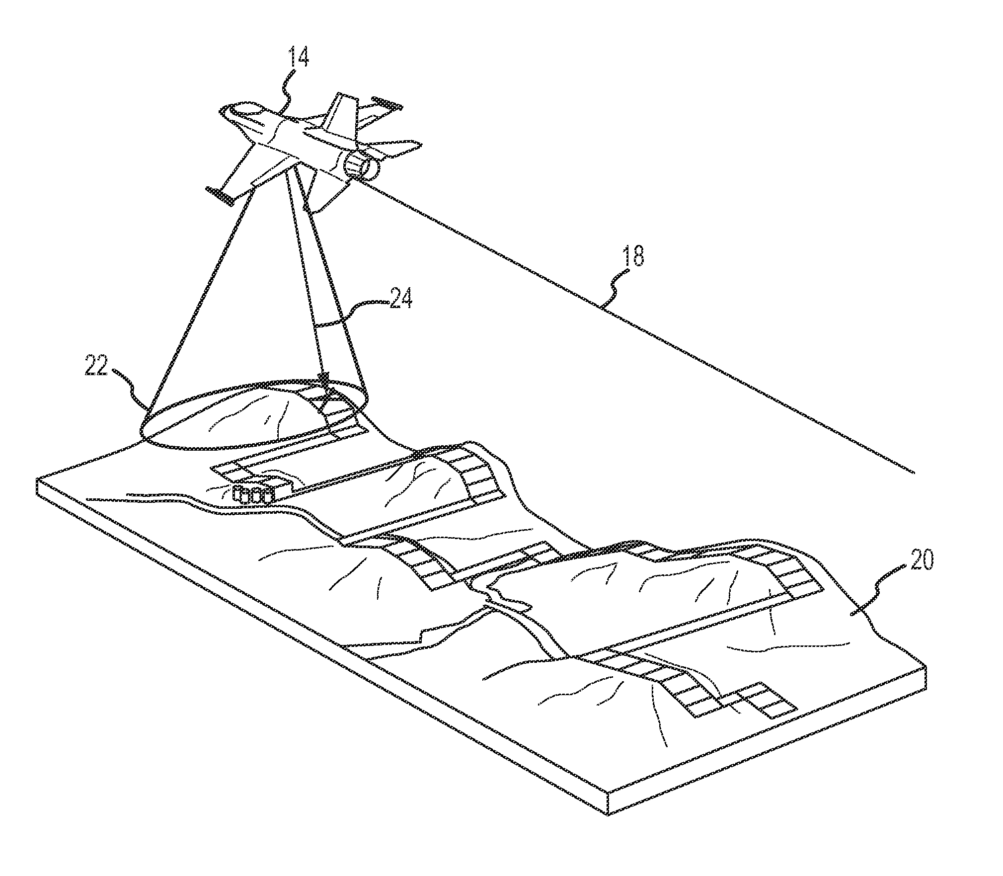
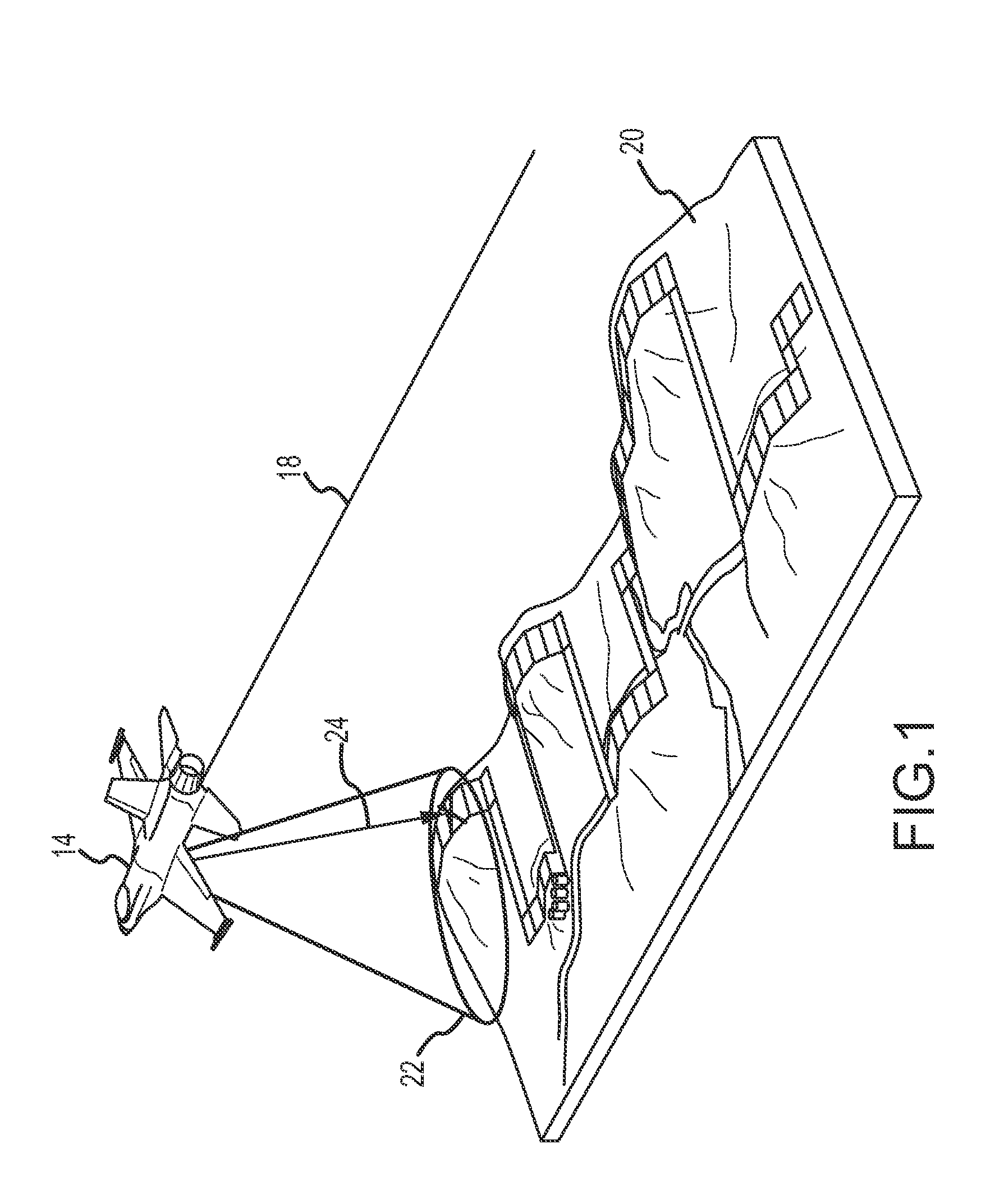
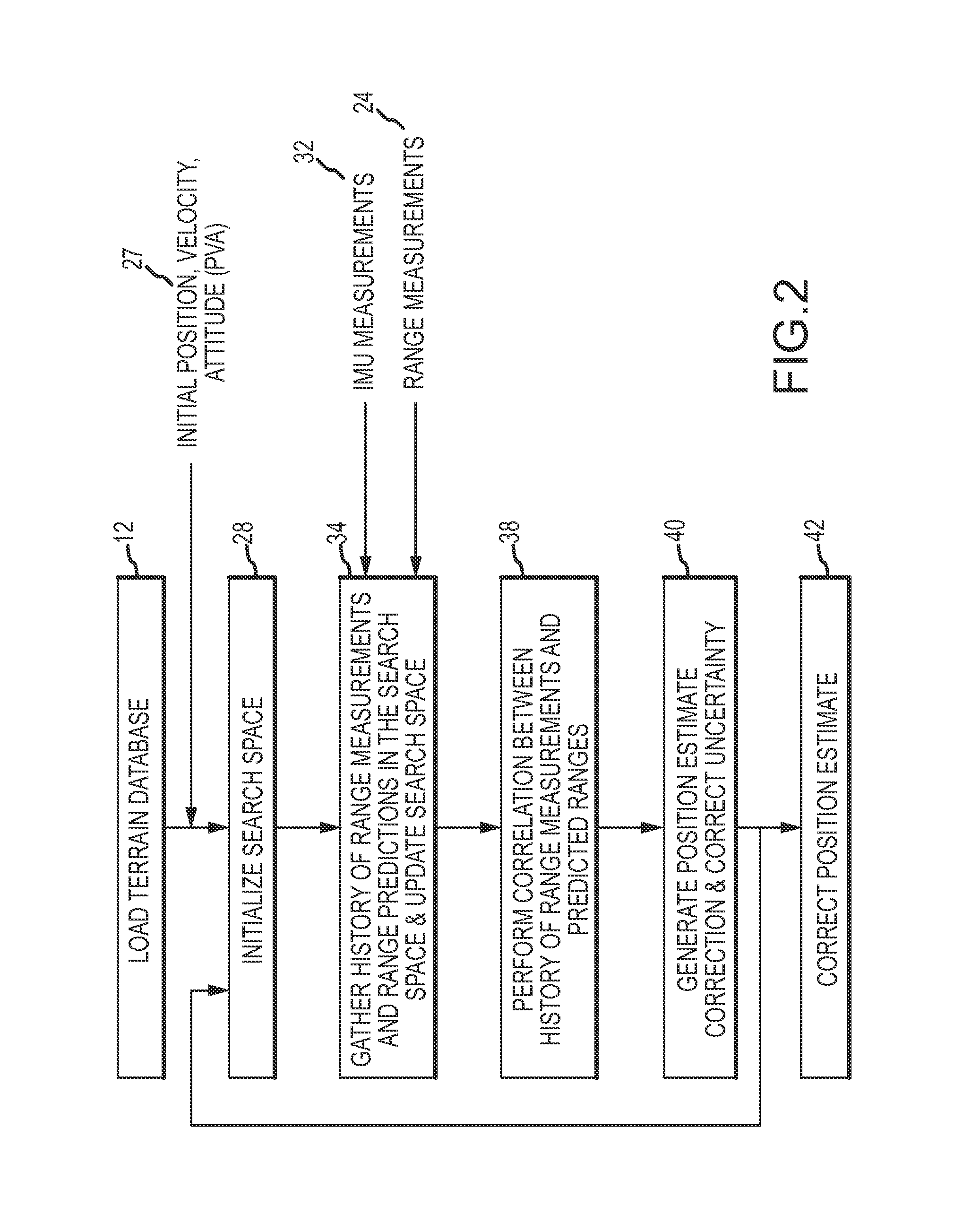
[0026]Neither conventional TERCOM nor any of the range-only improvements to TERCOM allow the format of terrain height maps or database to be fully independent of the flight of the vehicle. Even if the vehicle's current uncertainty basket inside which the correlation is performed were to be calculated during flight from the estimated position uncertainty, in all prior attempts the size of the uncertainty basket is held constant over the history of the radar altimeter measurements used for the correlation, which does not account for any growth of the position error over the measurement history. If the distance between the true position of the vehicle and the estimated position drifts outside of the original uncertainty basket, then the algorithm may correlate to an erroneous solution. Also, in all prior range-only methods, the spacing used in the terrain height maps or database is the same as the spacing used in correlation process, and therefore must be managed carefully to allow the...


PUM


Abstract

AROTAN provides for autonomous terrain aided navigation that is fully independent of the position uncertainty of the vehicle during flight. AROTAN aligns a grid to the search space and periodically updates the search space during the measurement history to account for growth in position uncertainty. AROTAN computes terrain sufficiency statistics for a moving history to provide robust criteria for when to perform the correlation. A post-correlation refinement provides an additional correction of the horizontal position error and a correction of the altitude. AROTAN can quickly provide the vehicle's location based on the correlation from a single measurement history.

Description

BACKGROUND OF THE INVENTION[0001]1. Field of the Invention[0002]This invention relates to terrain aided navigation, and more particularly to autonomous range-only terrain aided navigation, that generates range predictions based on a model of the radar altimeter on a grid aligned to a search space that varies dynamically over a moving measurement history and upon satisfaction of terrain sufficiency criteria correlates the range predictions to the measurement history using a terrain height database with a format that is independent of the flight characteristics.[0003]2. Description of the Related Art[0004]Terrain Contour Matching (TERCOM). first developed in the 1950's and patented under U.S. Pat. No. 3,328,795, uses radar altimeter measurements to compute a history of terrain heights and correlates that history with terrain heights from a database map. TERCOM has been used for cruise missiles. The main limitation of TERCOM is the labor-intensive preparation to tailor a set of terrain...

Claims


Application Information

Patent Timeline
Patent Type & Authority Applications(United States)
IPC IPC(8): G01C21/00G01C21/20G05D1/00
CPCG01C21/005G05D1/0088G01C21/20G05D1/106
Inventor CAYLOR, THOMAS LEELANDON, JAMES THOMASGEIER, GEORGE JEFFREY
Owner RAYTHEON CO
Why Eureka
Try Eureka