Method and arrangement for locating a moble device

a technology of moble devices and mobles, applied in the field of moble devices, can solve the problems of inconvenient process, easy interruption of associated signal coverage, poor performance of the location tracking system based thereon, etc., and achieve the effect of facilitating current estimation and energy saving

Active Publication Date: 2017-03-02
GLOPOS FZC
View PDF0 Cites 54 Cited by
  • Summary
  • Abstract
  • Description
  • Claims
  • Application Information

AI Technical Summary

Benefits of technology

[0039]In some embodiments, the inertial sensor data may be used to determine the walking (gait) frequency, in case the mobile device is carried by a user moving by walking, by preferably filtering out noise and random variations from the data. Then by identifying the actual frequency, the frequency filter may be further adapted to separate consecutive steps from each other. By recognizing the walking frequency, the step / stride length may be determined and / or further calibrated by utilizing data, if available, from other sources such as e.g. GPS. This may then be utilized to enhance the locating of the device.
[0040]In some embodiments, the locating of the mobile device may be enhanced by utilizing inertial sensor data in recognizing the position of the mobile device, i.e., whether it is e.g. in user's pocket, next to user's ear while moving, or in user's hand. Accelerometer data in conjunction with gyroscope data may be utilized to identify to position of the mobile device with respect to the direction of gravity. The direction of the movement with respect to the direction of gravity and the position of the mobile device is typically approximately constant when the user is e.g. holding the mobile device in his hand while moving. The position of the mobile device may be calibrated with location data from other sources such as e.g. GPS, Wi-Fi or cell data. The position may also be calibrated by utilizing frequency filtered data of the movement of the mobile device in horizontal direction. With determined walking frequency and / or stride / step length in conjunction with the motion model, the accuracy of locating and mapping of the mobile device may be further improved. The acceleration in the direction of the movement may also be utilized and thus, the effect of random sidesteps to the locating may be minimized.
[0046]The utility of the present invention arises from a great variety of issues depending on each particular embodiment thereof. Based on relatively low frequency and low amount of real-time data acquired, the mobile devices and thus also their users or other carriers, such as vehicles or other objects, may be positioned rapidly and accurately by relying on motion models in addition to the probability map structures and optionally route data. Furthermore, for example, cellular network data based positioning without at least constantly relying on Bluetooth, GPS or e.g. wireless local area network (WLAN) is very energy efficient in contrast to traditional solutions.
[0047]The motion models facilitate estimating the current and predicting the future location of the mobile device through fitting the environmental data, which is preferably obtained at a plurality of time instances (data representing certain single time instant only renders any true motion modeling or model fitting practically impossible as being understood by a person skilled in the art, because several samples with sequential temporal relationship should be available to make motion analysis meaningful), in the motion characteristics of the model(s) such as direction, speed / velocity, acceleration / deceleration, turns, etc. As a result, location probabilities determined based on the probability map(s) may be adjusted (probabilities changed) by one or more motion models so that the probabilities of locations matching well with the model are raised and vice versa.
[0050]By the utilization of sensor data readily available at modern mobile devices, both the mapping and locating accuracy may be enhanced or preserved in conditions wherein actual positioning data such as GPS data cannot be received and e.g. wireless network such as Wi-Fi or cellular network based data is not sufficient. For instance, mapping activities involving linking position data with environment data via a probability map structure may exploit explicit positioning data such as satellite positioning data in outdoors or other conditions of good coverage, and switch over to exclusive or parallel usage of e.g. inertial sensor data-based location estimation while continuing mapping of environmental data (e.g. cellular data, magnetometer data) indoors.

Problems solved by technology

However, the associated signal coverage easily suffers from interruptions caused by landscape obstructions such as geographic features, buildings or related urban canyon, trees, etc.
Because mobile devices are often operated in positioning-wise challenging environments, such as cities and urban areas, wherein GPS or generally satellite navigation signal reception will be intermittent, this can result in poor performance of the location tracking system based thereon.
The start-up of a GPS-receiver typically requires the initial estimate of its location and this process takes several minutes.
Despite of its obvious benefits in certain use scenarios, it may also easily result in inaccurate location estimate because certain environment obstructions and their influences are ignored during the process.
Yet, the location estimation procedures described above don't make any estimation of a type of the cell with regard to landscape and cityscape, etc.
By concentrating the locating efforts around any certain, single type of data source or a related model may not give optimum results during real-time positioning, when a variety of data sources in terms of different network signals, etc. are available and detectable by the object to be positioned.
Further, many of the contemporary positioning solutions work lousily in situations where data input space used for locating a target device is at least momentarily and e.g. abruptly reduced or severely distorted, whereupon a position estimates solely based on the latest data input is easily very erroneous.

Method used


Image

  • Method and arrangement for locating a moble device
  • Method and arrangement for locating a moble device
  • Method and arrangement for locating a moble device

Examples


Embodiment Construction

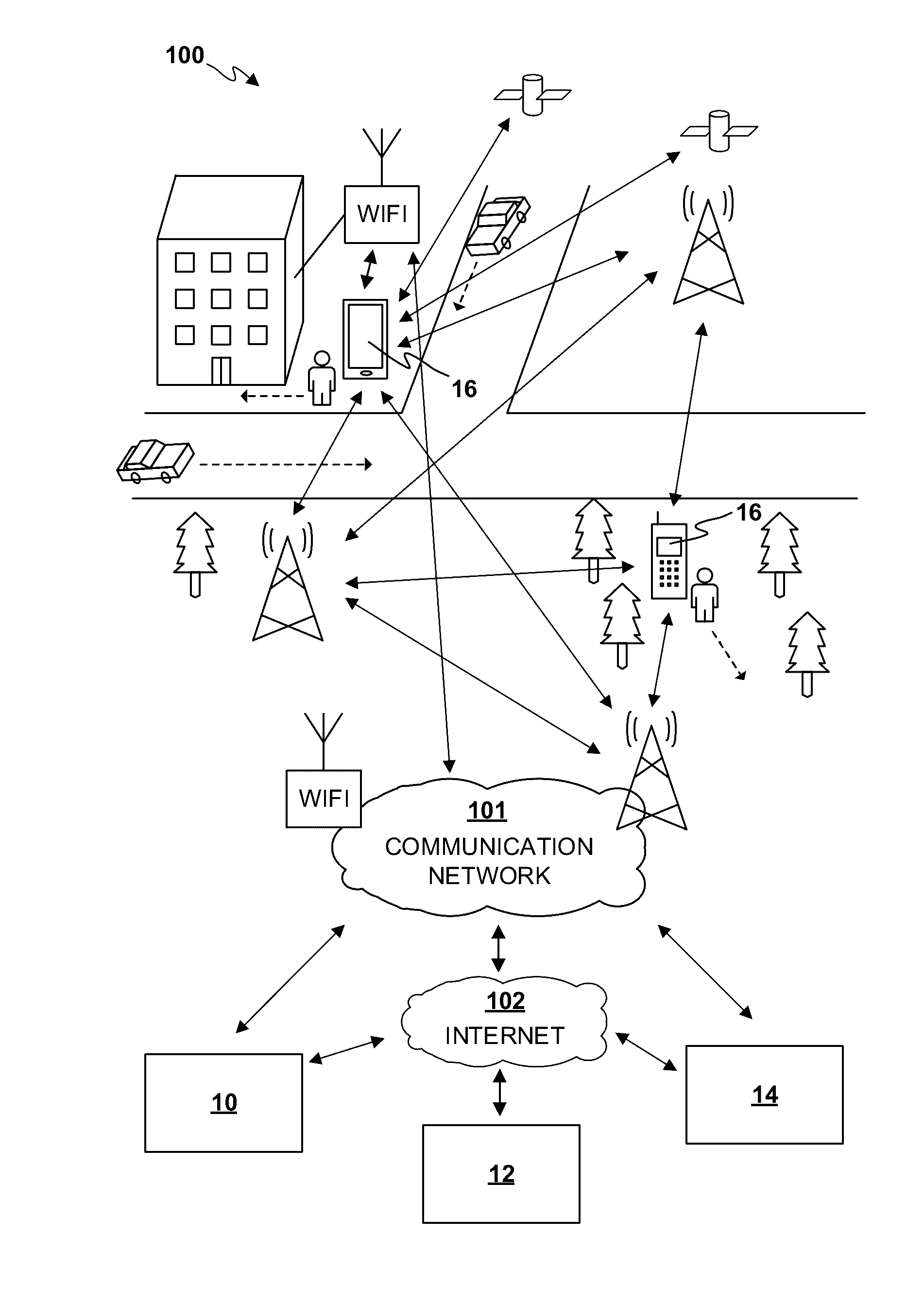
[0066]FIG. 1 illustrates, at 100, an embodiment of the present invention via a merely exemplary use scenario thereof. The locating system may be at least partly disposed in a number of servers 10 residing as accessible via communications network(s) such as the Internet and / or cellular network(s). Optionally, a cloud computing environment 12 providing efficient and easy scalability of resources may be utilized to implement the system. In some other embodiments, the mobile devices 16 to be located may be self-contained in a sense that they may locally execute a locating method in accordance with the present invention preferably even if no Internet or other communications connection exists with elements 10, 12, 14 accessible via the Internet and / or other network(s).

[0067]In some further embodiments, the mobile devices 16 may be located by the (network) arrangement through utilization of information the mobile devices 16 provide to the network. At least part of the information may be su...


PUM


Abstract

A method for locating an electronic mobile device capable of wireless communication, the method including obtaining a probability map structure for the area of interest, the probability map structure associating environment data values, preferably including cellular network based data, with location data, obtaining a number of probabilistic temporospatial motion models for different types of motion, the models at least partly defining transition probabilities between location estimates relative to time, obtaining at least environment data captured or determined by the mobile device at a plurality of sequential time instances, and determining the most probable location estimate of the mobile device based on combining probability data from both the probability map structure and the motion models, wherein the at least environment data is best fitted in the motion models and probability map structure according to predefined criteria. Related two arrangements and a computer program are presented.

Description

TECHNICAL FIELD OF THE INVENTION[0001]This invention relates generally to locating mobile devices comprising mobile positioning or positioning-enabling technology. More particularly the invention relates to solutions for determining a location of a mobile device in which the locating is based on captured or determined environment data.BACKGROUND OF THE INVENTION[0002]The need for locating a mobile device or its user may come from the user desiring to know one's own location or from an authority for which the information about the location of a person has become important for some reason, e.g., in a case of emergency.[0003]Location tracking devices and other such mobile terminals, e.g. smartphones or other hand-held or wearable apparatuses, may comprise cellular communication functionality such as a transceiver for collecting cellular data from nearby cells / base stations, e.g. indications of signal strength, and reporting it to a receiver at the remote location, and most typically, a...

Claims


Application Information

Patent Timeline
Patent Type & Authority Applications(United States)
IPC IPC(8): H04W4/04H04W4/02H04W4/021
CPCH04W4/043H04W4/027H04W4/026H04W4/021G01S5/0278G01S5/02522G01S5/017G01S19/252
Inventor HEIKKILA, TIMOVAINIO, MIKAEL
Owner GLOPOS FZC
Why Eureka
Try Eureka