System and Method for Performing Distant Geophysical Survey

a geophysical survey and distant technology, applied in the field of distant geophysical survey, can solve the problems of affecting well placement, reservoir production and drilling safety, low distance resolution and/or formation property accuracy, etc., to improve the signal-to-noise ratio, improve the understanding, and improve the stability, repeatability and reliability of downhole tools and surface sensors.

Active Publication Date: 2017-04-06
GROUNDMETRICS
View PDF1 Cites 15 Cited by
  • Summary
  • Abstract
  • Description
  • Claims
  • Application Information

AI Technical Summary

Benefits of technology

[0011]This invention relates to the creation and use of subsurface resistivity mapping with sufficient accuracy and distance resolution for use during the planning, drilling, logging, and reservoir production processes. Preferably the mapping is 3D, but 2.5D, 2D and even 1D can be useful as well. This invention improves the understanding of the macro level view of the subsurface geology and / or formation fluids and the position of the wellbore with respect to the formation and / or fluids via the use of capacitive sensors, one or more sources, processing software, and interpretation software. The use of capacitive sensors improves the signal-to-noise ratio and the stability, repeatability and reliability of downhole tools and surface sensors. Preferably multiple sources are used to illuminate the subsurface formations from various positions, with one or more sources being located, for example, on the surface, the downhole drilling tool or the drill string itself (with the use of a gap sub). A borehole conductor can also be used as one of the sources. A borehole conductor can comprise any conductive material or combination of conductive materials associated with a borehole, including but not limited to the casing, tubing, rods, wires, cables, and / or fluids. Alternatively, a borehole conductor comprises a conductor added to the borehole, either temporarily or permanently, such as an electrode commonly used in borehole-to-surface methods. Preferably real-time and post-processed data are used in conjunction with other data to improve confidence in the interpretation.

Problems solved by technology

The understanding of the relationship of subsurface geology and wellbore placement is limited to either surface systems, which provide overall low distance resolution and / or formation property accuracy, or downhole systems, which only have the ability to investigate the area immediately around the wellbore.
This affects well placement, reservoir production and drilling safety because there is not a full understanding of the subsurface geology between the wellbores and ahead of the bit during the drilling process.
Each of these has limitations in resolving information about the fluid in the formations and in distance resolution, and / or they are operationally intrusive (i.e., they require significant changes in work methods, which is costly).
Seismic information requires knowledge of the low frequency sound velocity in each formation to determine distance, access to cost-prohibitive equipment and does not provide resistivity values used to determine formation fluid type.
Tomography requires access to producing wellbores, which are typically not located in optimal locations to allow evaluation, and production has to be halted during the tomography process.
Use of drilling formation evaluation tools provides high accuracy resistivity values with distance from wellbore placement but has a very limited depth of investigation (that is, how much subsurface geology can be mapped) and are limited or cannot investigate regions in front of the drill.
EM and seismic tomography methods (as well as cross-well EM methods) require access to existing wellbores and that production be halted, therefore making them unlikely to be used during the drilling process.
Logging-while-drilling (LWD) formation evaluation tools have acceptable resistivity and distance accuracy, but the depth of investigation is limited to 20 to 100 feet from the wellbore and generally if not always only lateral to the wellbore.
The issue is that these surveys are limited in their depth extent, have accuracy and resolution limitations, and can be negatively influenced by galvanic surface sensor setup and performance, including but not limited to electrochemical behavior and noise caused by poor coupling to the earth.
Other techniques have been developed that partially address these limitations but also introduce other issues.
However, EM tomography requires wellbore intervention, has a fixed subsurface volume it can image, and has no real-time applicability.
Transmitting at more than one depth location improves resolution, but increasing the number of transmit depths quickly diminishes in added value and dramatically increases costs.

Method used


Image

  • System and Method for Performing Distant Geophysical Survey
  • System and Method for Performing Distant Geophysical Survey
  • System and Method for Performing Distant Geophysical Survey

Examples


Embodiment Construction

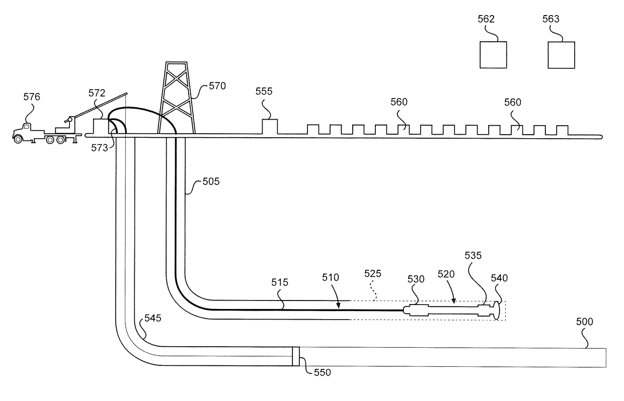
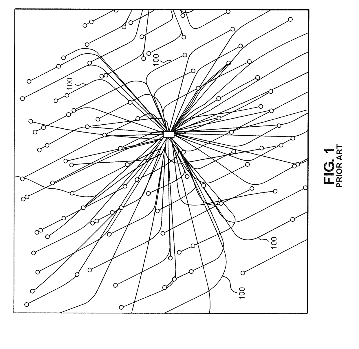
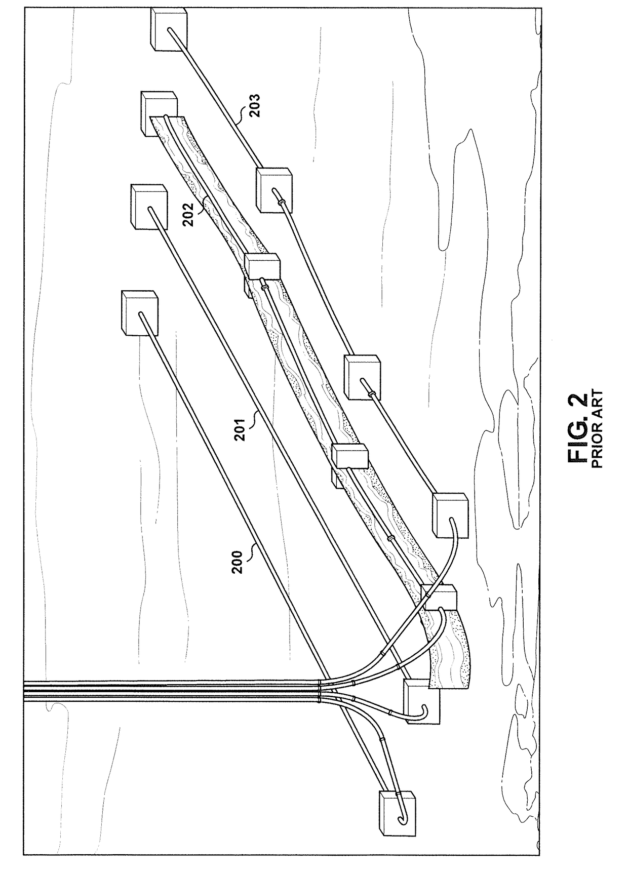
[0031]Detailed embodiments of the present invention are disclosed herein. However, it is to be understood that the disclosed embodiments are merely exemplary of the invention that may be embodied in various and alternative forms. The figures are not necessarily to scale, and some features may be exaggerated or minimized to show details of particular components. Therefore, specific structural and functional details disclosed herein are not to be interpreted as limiting, but merely as a representative basis for teaching one skilled in the art to employ the present invention. The foregoing description of the figures is provided for a more complete understanding of the drawings. It should be understood, however, that the embodiments are not limited to the precise arrangements and configurations shown. Although the design and use of various embodiments are discussed in detail below, it should be appreciated that the present invention provides many inventive concepts that may be embodied ...


PUM


Abstract

A downhole drilling tool is adapted to be placed in a borehole formed in the earth. The downhole drilling tool has mounted thereto at least one of a transmitter for generating and a receiver for sensing at least one component of an electromagnetic field within a distant earth region. The tool also has a device configured to acquire subsurface data from the at least one component of the electromagnetic field; and a device configured to calculate a resistivity distribution of the distant earth region from the subsurface data. A geophysical survey is performed with a downhole drilling tool by transmitting at least one component of an electromagnetic field through the distant earth region; acquiring subsurface data from the at least one component of the electromagnetic field; and calculating a resistivity distribution of the distant earth region from the subsurface data.

Description

CROSS REFERENCE TO RELATED APPLICATIONS[0001]This application claims the benefit of U.S. Provisional Application No. 62 / 237,832, which was filed on Oct. 6, 2015 and titled “Electromagnetic Geosteering and Wellbore Trajectory Estimation”, and U.S. Provisional Application No. 62 / 244,403, which was filed on Oct. 21, 2015 and titled “Capacitive Logging System”. The entire content of these applications is incorporated herein by reference.BACKGROUND OF THE INVENTION[0002]The embodiments described herein relate generally to soundings within the earth based upon electrical fields. As used herein, “earth” or “Earth” generally refers to any region in which a borehole may be located including, for example, the lithosphere. Electromagnetic (EM) geophysical surveys probe electrical resistivity, or equivalently, conductivity, in the earth as a function of depth. Typical targets of interest include ore bodies, hydrocarbons, water, steam, proppants, hydraulic fracture (or fracking) fluids, salts an...

Claims


Application Information

Patent Timeline
Patent Type & Authority Applications(United States)
IPC IPC(8): G01V3/26E21B7/04E21B47/12E21B49/00
CPCG01V3/26E21B47/122E21B7/04E21B49/00E21B47/00E21B47/12E21B47/022E21B47/13E21B47/125E21B47/0228E21B47/0232
Inventor EISKAMP, GEORGE
Owner GROUNDMETRICS
Why Eureka
Try Eureka