Joint non-coherent integral vector tracking method based on spatial domain

a spatial domain, non-coherent technology, applied in satellite radio beaconing, measurement devices, instruments, etc., can solve the problems of large acceleration or jerk, large initial tracking difficulty, and general commercial gps receivers that cannot work normally, etc., to achieve high dynamic environment, low signal to noise ratio, and high tolerance capability

Active Publication Date: 2017-09-28
SOUTHEAST UNIV
View PDF2 Cites 5 Cited by
  • Summary
  • Abstract
  • Description
  • Claims
  • Application Information

AI Technical Summary

Benefits of technology

[0017](1) a GPS receiver based on a vector tracking loop has a much higher tolerance capability on a low signal to noise ratio and a high dynamic environment than that of the traditional GPS receiver, and the vector tracking GPS receiver has a better performance than that of the traditional receiver.
[0018](2) In a traditional GPS receiver, a tracking module contains several independent tracking loops with consistent functions, and each tracking loop performs independent tracking and processing on a single path of GPS satellite signals. Different from the traditional receiver, the vector tracking receiver in the present invention has only one tracking module called navigation filter, and the navigation filter is capable of performing tracking processing on the GPS satellite signals of all channels simultaneously, while also completing the task of calculating the position and velocity of the receiver. Since the vector GPS receiver uniformly processes the satellite signals of all channels, and dynamic tracking on the receiver is jointly completed by the signals of all channels, it has many advantages.
[0019](3) When a traditional scalar tracking loop is used, each tracking channel must depend on itself to track the change in visual direction Doppler frequency and code phase change of one GPS sat

Problems solved by technology

In a high dynamic environment (aerospace field, launch vehicles, satellites and missiles), a GPS receiver is in a high-speed movement state and may have a very large acceleration or a jerk, and general commercial GPS receivers cannot work normally.
(1) it is required to complete an acquisition process as soon as possible and enter into a tracking process, and too large Doppler frequency shift may bring about a great difficulty to initial tracking, and in this situation, the tracking loop may only use a frequency-locked loop or a phase-locked loop with a wider bandwidth;
(2) since the Doppler frequency shift changes violently, an integration time must be very short, otherwise, a tracking bandwidth of the phase-locked loop or the freque

Method used


Image

  • Joint non-coherent integral vector tracking method based on spatial domain
  • Joint non-coherent integral vector tracking method based on spatial domain
  • Joint non-coherent integral vector tracking method based on spatial domain

Examples


Embodiment Construction

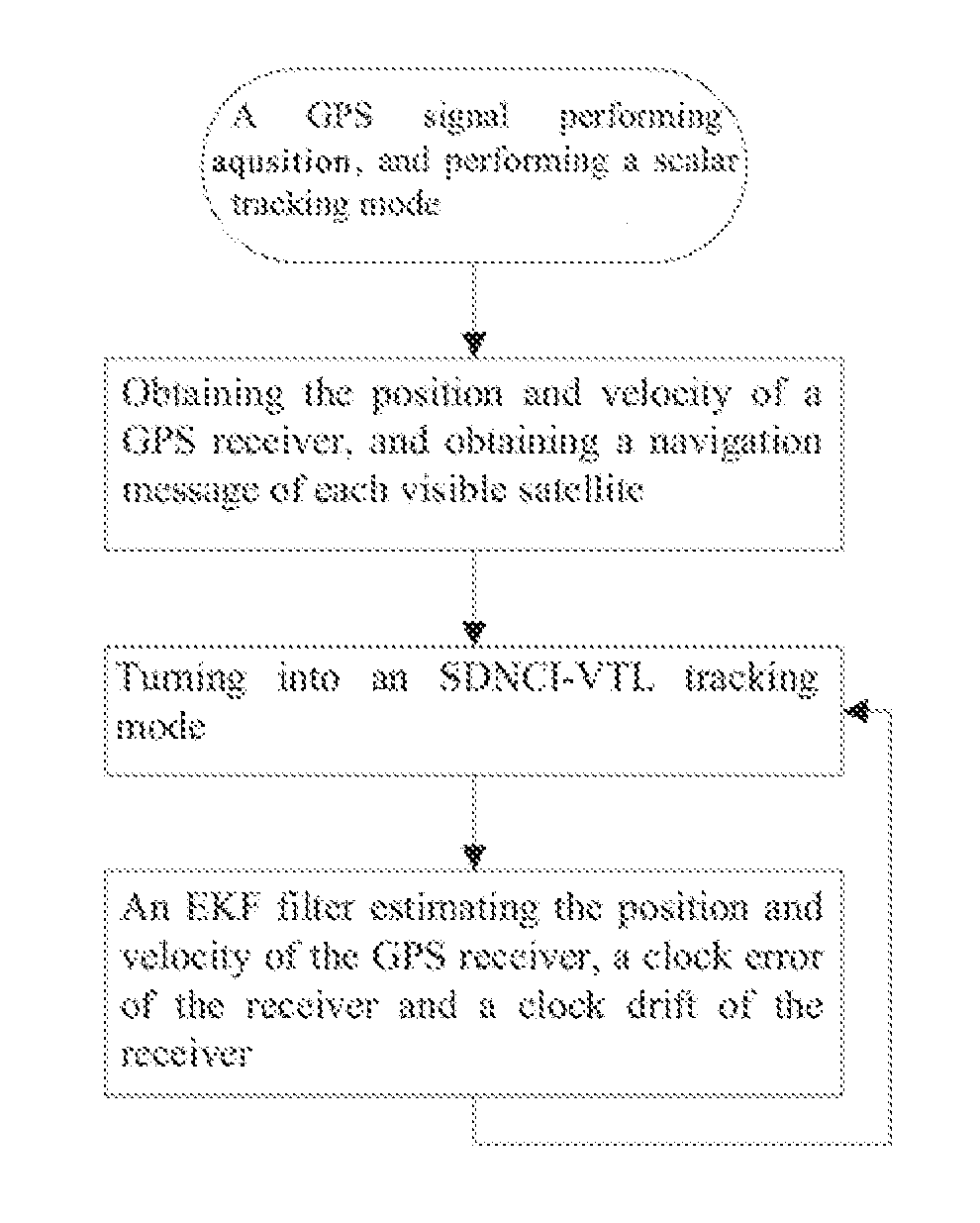
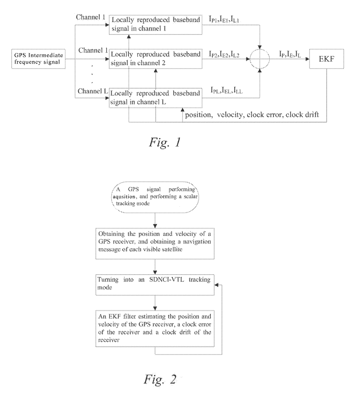
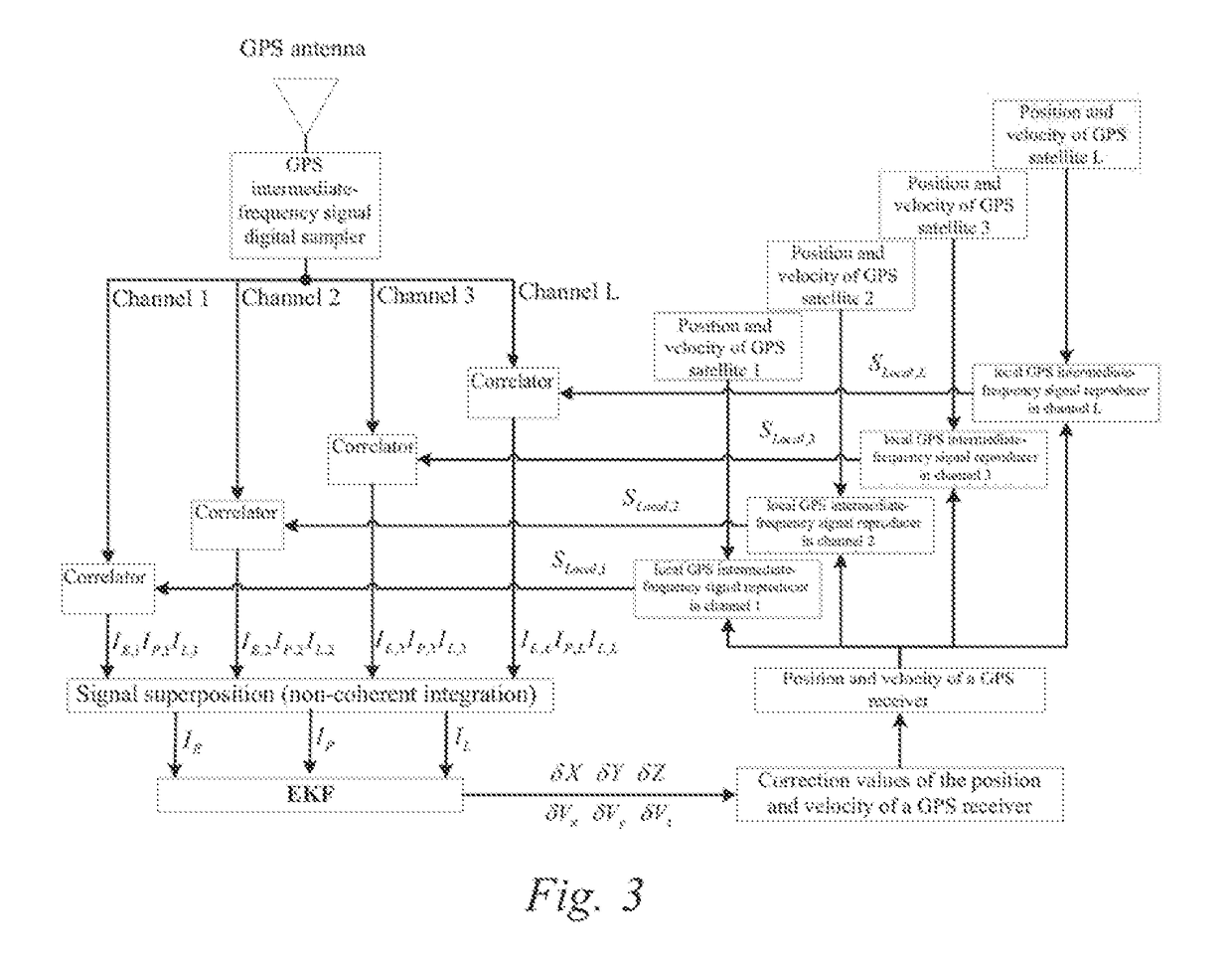
[0025]In the working process of the GPS receiver, in order to obtain a pseudo range (distance) and a pseudo range rate (the visual direction velocity) of each tracking channel, it is required to use a received GPS intermediate-frequency signal and a local reproduced carrier and a reproduced pseudo random sequence of each tracking channel to perform coherent and integral calculations. We assume that the current moment is k moment, and the next moment is k+1 moment, in a tracking process, we need to utilize data at the k moment to estimate signal parameters of the k+1 moment.

[0026]Taking a tracking channel of the lth satellite as an example, assuming that a pseudo random code phase at the current moment is τl,k (unit: meter), a pseudo random code frequency is ƒcode, l, k (unit: chip / second), a clock error of the GPS receiver is ti, k (unit: meter), a clock drift of the GPS receiver is td,k (unit: meter / second), the position of the GPS receiver is Pk, the velocity of the GPS receiver i...


PUM


Abstract

The present invention discloses a joint non-coherent integral vector tracking method based on a spatial domain, which is used for further improving the performance of a vector tracking GPS (Global Positioning System) receiver. In a new vector tracking strategy design, a phase discriminator/a frequency discriminator in a traditional vector tracking loop is discarded, and baseband signals of visible satellites in each channel are taken as an observation value after performing non-coherent integration, and EKE (abbreviation of Extended Kalman Filter) is used to estimate directly and to solve the position, the velocity, a clock error, etc. of the GPS receiver. Because of the existence of non-coherent integral calculation, when GPS satellite signals are relatively weak, a carrier to noise ratio of an observation value may be effectively improved, and the tracking sensitivity is improved.

Description

CROSS REFERENCE TO RELATED APPLICATIONS[0001]This application is the national phase entry of International Application No. PCT / CN20161087280, filed on Jun. 27, 2016, which is based upon and claims priority to Chinese Patent Application No. 20151068641,1.5 filed on Oct. 20, 2015, the entire contents of which are incorporated herein by reference.TECHNICAL FIELD[0002]The present invention relates to the technical field of navigation positioning with a medium and low precision requirement, such as city traffic and voyage, and develops, in order to meet navigation positioning requirements such as high precision, high reliability and a large positioning coverage range, a new satellite signal tracking technology on the basis of a traditional GPS software receiver technology, thereby realizing seamless positioning in weak satellite signals and high dynamic environments, etc.BACKGROUND[0003]In a high dynamic environment (aerospace field, launch vehicles, satellites and missiles), a GPS recei...

Claims


Application Information

Patent Timeline
IPC IPC(8): G01S19/25G01S19/24G01S19/23G01S5/02
CPCG01S19/256G01S19/235G01S19/246G01S5/0294G01S19/37G01S19/30
Inventor CHEN, XIYUANYANG, YANGWANG, XIYINGCUI, BINGBOTANG, XINHUAZHU, XUEFEN
Owner SOUTHEAST UNIV
Why Eureka
Try Eureka