Method and System for Video-Based Positioning and Mapping

Pending Publication Date: 2020-03-26
TOMTOM LOCATION TECH GERMANY GMBH +1
View PDF0 Cites 85 Cited by
  • Summary
  • Abstract
  • Description
  • Claims
  • Application Information

AI Technical Summary

Benefits of technology

[0091]The result of grouping three-dimensional representations from different images is that each of the groups contains a set of substantially overlapping representations, which can thereby be associated with the same physical landmark detected in multiple different frames. That is, any three-dimensional representations that are associated with the same physical landmark will generally be expected to line up in the coordinate space and may thus be grouped together on this basis. However, any three-dimensional representations that are based on inaccurate detections will appear scattered in the coordinate space, and may thus be discarded as outliers (and not included in the groups). The grouping therefore allows any false positive, or otherwise inaccurate, landmark detections to be removed in order to provide a more accurate identification of the landmarks.
[0092]The three-dimension representations in each group may then be fused together to determine a single

Problems solved by technology

The limited resources in a car impose algorithms and data structures which use computation time, memory and mobile bandwidth economically.
Still, many challenges that are required for full autonomy are not solved and the research community did not yet determine all the prerequisites for safe planning and driving, but even known problems exist, to which there is no definite solution.
While there are numerous propositions and implementations for autonomous driving platforms, none has gained the status of an accepted standard solution for the mapping and localisation problem.
There is also no standard solution for aggregating ad-hoc data into an on-the-fly map which simultaneously facilitates immediate motion planning and additional map matching (i.e. localisation) against a pre-built map on a global scale.
The update of a pre-built map with new on-the-fly data is also crucial and not generally solved.
A further issue is the lack of pre-built map material which complies with the requirements of autonomous driving.
Most map data is gathered at infrequent intervals and is thus often out-of-date and does not offer easy methods to incorporate new data.
Much of the available map data is also not structured for algorithmic access, such as the aforementioned aerial photos, which are made up of pixels with no structural data available.
Map precision is also often not sufficient and calls for

Method used


Image

  • Method and System for Video-Based Positioning and Mapping
  • Method and System for Video-Based Positioning and Mapping
  • Method and System for Video-Based Positioning and Mapping

Examples


Embodiment Construction

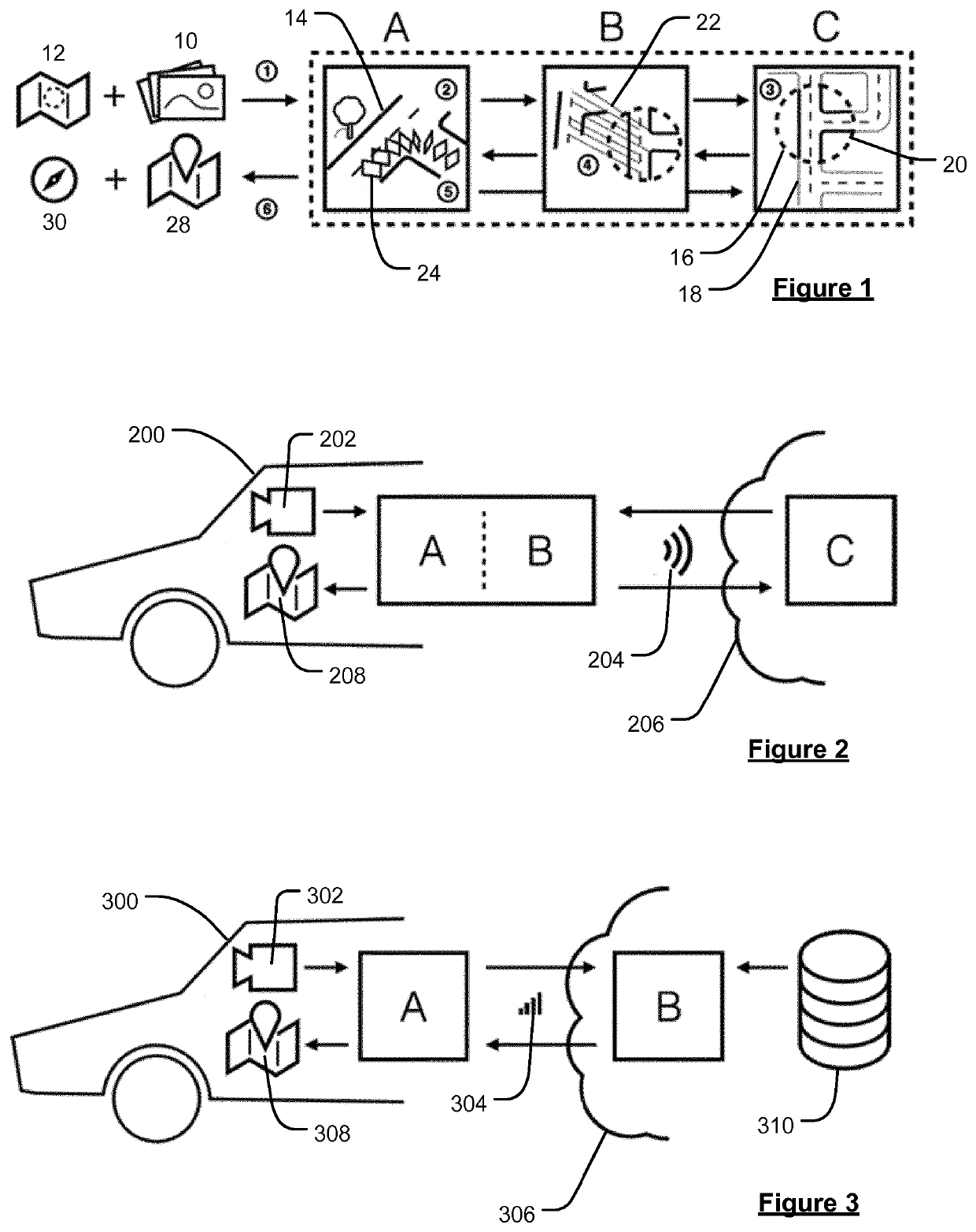
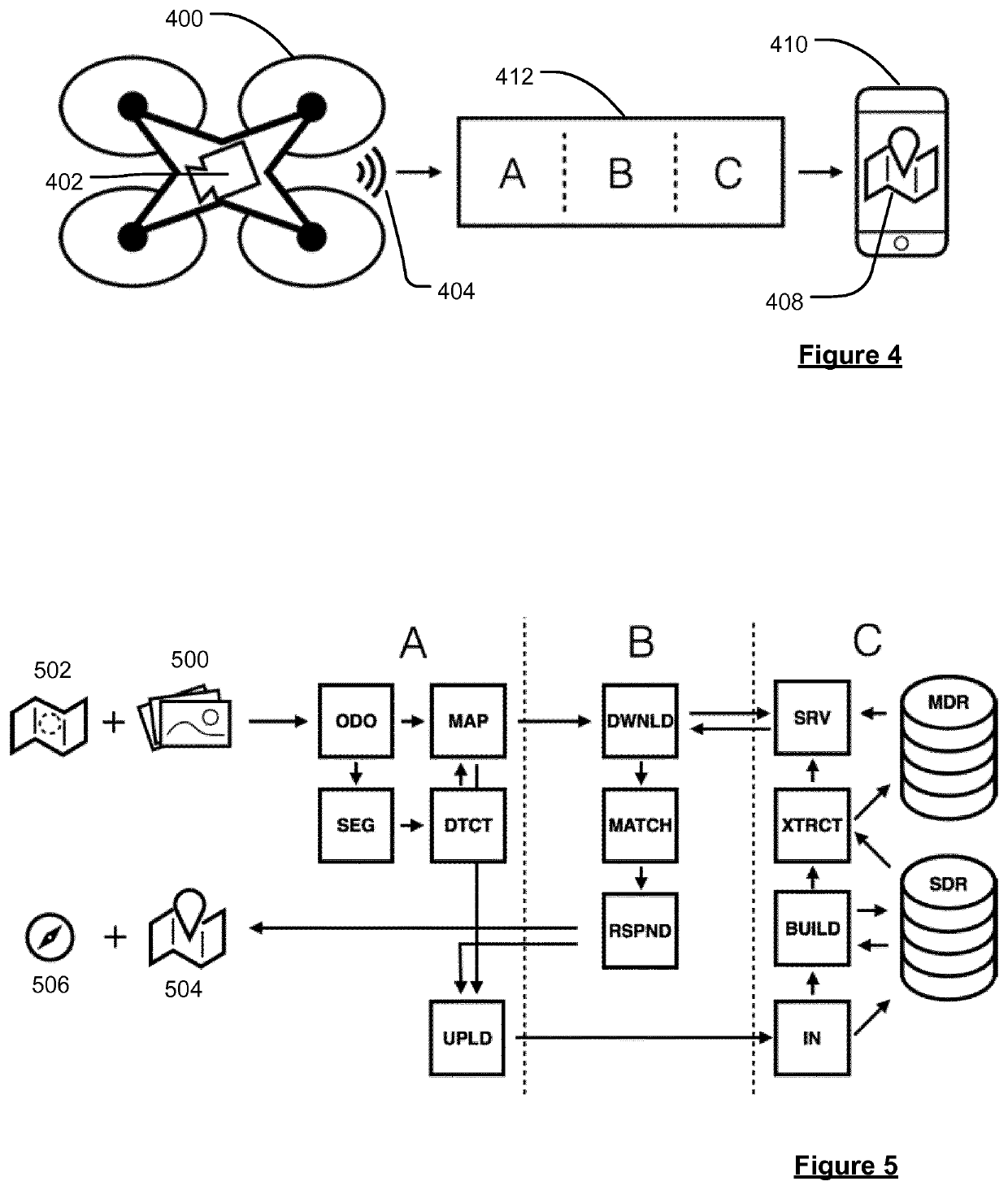
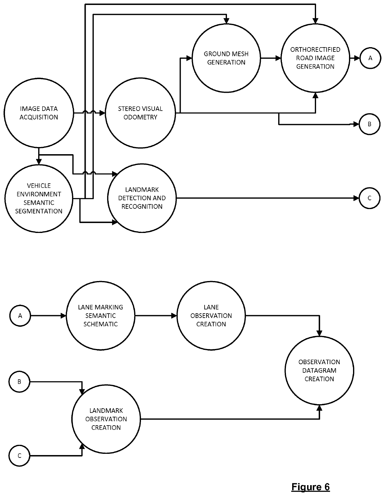
[0154]The present disclosure generally relates to providing improved technologies for determining a geographical location and orientation of an observer (vehicle), e.g. within a road network that is covered by a pre-built map. In embodiments, the present disclosure thus relates to techniques for Large-Scale Visual Geo-Localisation and Mapping, as will be explained below. The localisation techniques of the present disclosure may for instance be used to facilitate various autonomous driving functionality or to supplement or generate improved electronic maps, e.g. for use with autonomous driving. For instance, as explained above, autonomous driving typically requires the use of a map that provides at least information regarding the lane geometry in the locality of the vehicle, e.g. the lane centre lines and lane connectivity (rather than just the road centre lines, as may be provided in a standard digital map, e.g. for use by standard portable navigation devices, e.g. for use by non-au...


PUM


Abstract

A method and system for determining a geographical location and orientation of a vehicle (200, 300) travelling through a road network is disclosed. The method comprises obtaining, from one or more cameras (202, 302) associated with the vehicle (200, 300) travelling through the road network, a sequence of images (500) reflecting the environment of the road network on which the vehicle (200, 300) is travelling, wherein each of the images has an associated camera location at which the image was recorded. A local map representation representing an area of the road network on which the vehicle (200, 300) is travelling is then generated using at least some of the obtained images and the associated camera locations. The generated local map representation is compared with a section of a reference map, the reference map section covering the area of the road network on which the vehicle (200, 300) is travelling, and the geographical location and orientation of the vehicle (200, 300) within the road network is determined based on the comparison. Methods and systems for generating and/or updating an electronic map using data obtained by a vehicle (200, 300) travelling through a road network represented by the map are also disclosed.

Description

FIELD OF THE INVENTION[0001]The present disclosure refers to a method and a system for determining a geographical location and orientation of an observer, e.g. a vehicle travelling along a road network. Further, a method and system for generating and / or updating an electronic map (i.e. for mapping) is provided. In embodiments, a visual global positioning and mapping system may be provided.BACKGROUND TO THE INVENTION[0002]Navigation and motion planning are crucial components of highly automated and autonomous driving. An autonomous vehicle needs to be able to automatically localise itself within the world to determine a safe course of action. On the one hand a map is needed to allow localisation on a global scale for route planning which is solved by global navigation satellite systems. On the other hand a precise geometric representation of the immediate environment is required for functions like lane keeping and adherence to traffic signage. Conventionally, this is solved either so...

Claims


Application Information

Patent Timeline
IPC IPC(8): G06T7/73G01C21/32G06F16/29G06F16/587G06K9/00G06T7/11
CPCG01C21/32G06T7/11G06T2207/10016G06F16/29G06F16/587G06K9/00798G06T2207/30256G06K9/00818G06T7/74G06T2207/30244G06F16/583G01C21/3811G06V20/582G01C21/3848G06T7/75G06T2207/30252G01C21/3859G06V20/588
Inventor GANJINEH, TINOSCHHOLZCHNEIDER, PHILIPPSCHACHMANN, DIMITRIMANN, SERGEJIHLEFELD, SEBASTIANHOFMANN, MICHAELBOOIJ, OLAFLEAL WERNECK, NICOLAU
Owner TOMTOM LOCATION TECH GERMANY GMBH
Why Eureka
Try Eureka