Method for localizing a vehicle

a technology for localizing vehicles and vehicles, applied in the field of methods and systems for localizing vehicles, can solve the problems of low accuracy of first position data, inability to accurately calculate second position data, and inability to accurately detect the position of the vehicle, so as to increase reduce the computational effort, and improve the accuracy of position information.

Active Publication Date: 2020-08-06
VISTEON GLOBAL TECH INC
View PDF0 Cites 2 Cited by
  • Summary
  • Abstract
  • Description
  • Claims
  • Application Information

AI Technical Summary

Benefits of technology

[0009]According to an aspect, a method for localizing a vehicle comprises a step of transmitting first position data related to a first position of the vehicle at a first point in time from the vehicle to a server. The first position data can comprise a plurality of data items related to position information including coordinates and / or an orientation of the vehicle obtained from a global navigation satellite system (GNSS) and / or localization objects detected in a vicinity of the vehicle and / or accuracy information describing the uncertainty of the position information and / or a time stamp related to the (first) point in time associated with the position information. In particular, the accuracy of the first position data can be relatively low. For example, a GNSS coordinates may be received by a GPS (global positioning system) receiver, which may deliver position information of the vehicle with an uncertainty of about ten to fifteen meters, which is too inaccurate for autonomous driving. In order to increase the accuracy of the position information, the position of the vehicle may be determined more precisely by comparing objects detected in the vicinity around the vehicle with objects on a digital map.
[0011]According to an aspect, the method comprises a step of computing, by the server, second position data related to the first position of the vehicle at the first point in time based on the received first position data. The location accuracy of the second position data is much higher than that of the first position data. In particular, the uncertainty of the second position data is on a level which is sufficient for autonomous driving, for example a few centimeters up to about ten to fifteen centimeters. On the other hand, the computational effort of computing the second position data may be relatively high. Therefore it is advantageous to carry out these calculations at a server, where available resources and computational power is not limited by boundary conditions found in a vehicle. Another advantage of outsourcing the computation of the second position data to a server is that local processing resources of the vehicle can be used for other tasks, such as controlling and steering the vehicle, planning a trajectory, and / or detecting localization objects in the vicinity of the vehicle. The second position data can be computed for example by matching the first position data with a high-definition map stored at the server.
[0013]According to an aspect, the method comprises a step of computing, by the vehicle, third position data related to a second position of the vehicle at a second point in time based on the received second position data, wherein the second point in time is later than the first point in time. The third position data may describe the actual current position of the vehicle. Accordingly, the second point in time can be the present point in time. After receiving the second position data from the server, the vehicle uses the received second position data to update the relatively inaccurate first position data with the highly accurate second position data. Thus, the available information about the vehicle's position at the first point in time can be improved. Using the now available second position data, the third position data for the second point in time can be computed. Thus, the vehicle can improve the accuracy of determining its own location at the current second point in time using the second position data of the past first point in time.
[0020]According to an aspect, the steps for obtaining the first position data, the second position data, and the third position data are carried out at predetermined, recurring time intervals. The time interval may depend on the vehicle's motion or on the uncertainty of the first position data. For example, the vehicle may send first position data to the server every ten, every twenty, or every thirty seconds or more and subsequently receive the second position data for improving the accuracy of the current location.
[0030]According to an aspect, the localization unit may comprise a GPS receiver for receiving position data from a global navigation satellite system (GNSS) and / or at least one position sensor for generating sensor data by detecting a plurality of localization objects around the vehicle. In particular, the at least one position sensor may include at least one of: a radar sensor, an infrared sensor, a stereo-camera, a LiDAR sensor, and a laser sensor. In certain embodiments, a combination of sensors may be used which allows for a reliable detection of localization objects in a plurality of different weather and lighting conditions.

Problems solved by technology

In particular, the accuracy of the first position data can be relatively low.
For example, a GNSS coordinates may be received by a GPS (global positioning system) receiver, which may deliver position information of the vehicle with an uncertainty of about ten to fifteen meters, which is too inaccurate for autonomous driving.
On the other hand, the computational effort of computing the second position data may be relatively high.

Method used


Image

  • Method for localizing a vehicle
  • Method for localizing a vehicle
  • Method for localizing a vehicle

Examples


Embodiment Construction

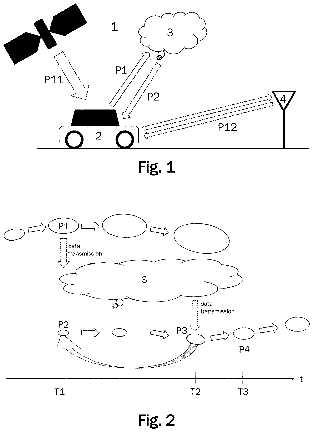
[0039]FIG. 1 schematically illustrates a system 1 for localizing a vehicle 2. The system 1 comprises a server 3 and a positioning device arranged in a motor vehicle 2. The server 3 may include any suitable server or computing device and may be located remotely from the vehicle 2 (e.g., in a cloud computing system or other suitable server or server system remotely located from the vehicle 2). The vehicle 2 has a control system for autonomous driving. The vehicle 2 can be described as a client to the server 3 which functions as a host serving a plurality of clients. The server 3 may be implemented in a cloud. Thus, the hardware associated with the server 3 does not need to be localized at a single physical location. The term server 3 rather describes the functional aspect of providing a data processing service which can be accessed by the clients via a network.

[0040]The server 3 comprises a first communication unit for receiving position data from the vehicle 2 and for sending positio...


PUM


Abstract

A method for localizing a vehicle comprises transmitting first position data related to a first position of the vehicle at a first point in time from the vehicle to a server. The server computes second position data related to the first position of the vehicle at the first point in time based on the received first position data. The server transmits the second position data from the server to the vehicle. The vehicle computes third position data related to a second position of the vehicle at a second point in time based on the received second position data. The second point in time is later than the first point in time.

Description

CROSS-REFERENCES TO RELATED APPLICATIONS[0001]This patent application claims priority to European Patent Application Serial No. 19155487.2, filed Feb. 5, 2019, which is incorporated herein by reference in its entirety.TECHNICAL FIELD[0002]One or more embodiments described herein relate to a method and a system for localizing a vehicle. In particular one or more embodiments related to a method and a system for determining the position of an autonomous motor vehicle with regard to a high-definition map are presented.BACKGROUND[0003]In order to safely navigate and steer an autonomous vehicle, it is important to precisely locate the position of the vehicle. Highly accurate positioning is a complex task and requires to match the measured position of the vehicle with a digital map. For this purpose, a high-definition (HD) map is generally used, which can be provided for example by a cloud to which the vehicle can connect via a network such as a mobile data network.[0004]The process of pro...

Claims


Application Information

Patent Timeline
Patent Type & Authority Applications(United States)
IPC IPC(8): G05D1/02G05D1/00G01C21/30
CPCG01C21/30G05D1/0274G05D1/0242G05D1/0257G05D2201/0213G05D1/0285G05D1/0278G05D1/0088G01C21/3602G05D1/0246G05D1/024G05D1/0282
Inventor OTTO, MATHIASPFEIFLE, MARTINBOCK, HENDRICK
Owner VISTEON GLOBAL TECH INC
Why Eureka
Try Eureka