Charging system which carries out data processing for fee payment

a charging system and data processing technology, applied in the field of charging systems, can solve the problems of insufficient infrastructure costs, affecting deteriorating position accuracy in proportion to the distance traveled, so as to improve the reliability of charging processing, accurate ground position, and low accuracy

Inactive Publication Date: 2005-01-18
TOYOTA JIDOSHA KK +1
View PDF19 Cites 58 Cited by
  • Summary
  • Abstract
  • Description
  • Claims
  • Application Information

AI Technical Summary

Benefits of technology

An object of the present invention is to carry out charging processing which has a relatively high degree of reliability, by using a relatively simple database for specifying positions.
In accordance therewith, when GPS positioning becomes impossible, in a case in which the cause thereof is due to a facility or a geographical feature, the monitor device computes the ground position by dead reckoning navigating, which is a positioning device which does not use radio waves such as moving synchronous pulses (vehicle speed pulses). As compared with a case using GPS positioning, the accuracy of the ground position is low. However, the monitor device detects, on the basis of geographical data, a facility or a geographical feature corresponding to the ground position, and corrects the ground position to this position. Thus, an accurate ground position is obtained. On the basis of this ground position, the charging processing device detects whether or not the moving body is in a charge region, and carries out data processing for charging in accordance with passing through the charge region. Thus, the reliability of charging processing improves. It suffices for the geographical data to include positions and configurations of facilities or geographical features (tunnels, roads between mountains, streets of big buildings) where GPS positioning is impossible. A database for specifying positions, which has a small amount of data and is simple and inexpensive, can be used.
In this way, by comparing positioning, which is determined by vehicle speed pulses and a gyro immediately before and immediately after GPS positioning is impossible, and positioning by GPS, correction of the positioning by the vehicle speed pulses of one's own vehicle by vehicle speed pulses and the gyro in the radio wave blocked interval can be carried out more accurately.
In this way, the abnormality information of the storage device (moving history table) is automatically emitted, and the charging management station receives the information, and can carry out monitoring of improper charging or leaks in charging.
In accordance with this method, when GPS positioning becomes impossible, in a case in which the cause thereof is due to a facility or a geographical feature, the ground position is computed by dead reckoning navigating. As compared with GPS positioning, the accuracy of the ground position is low. However, a facility or a geographical feature corresponding to the ground position is detected on the basis of geographical data, and the ground position is corrected to this position. Thus, an accurate ground position is obtained. On the basis of this ground position, it is detected whether or not the moving body is in a charge region, and data processing for charging in accordance with passing through the charge region is carried out. Thus, the reliability of charging processing improves. It suffices for the geographical data to include positions and configurations of facilities or geographical features (tunnels, roads between mountains, streets of big buildings) where GPS positioning is impossible. A database for specifying positions, which has a small amount of data and is simple and inexpensive, can be used.

Problems solved by technology

However, in this structure, infrastructure costs are required.
A drawback of dead reckoning navigating is that, even if the initial position is accurate, the positional accuracy gradually deteriorates in proportion to the traveled distance.
Further, with GPS positioning as well, there are cases in which an error of about 100 m arises.
However, a charging system, which combines a detailed map database for recognizing an accurate position with GPS positioning and dead reckoning navigating, is extremely expensive, which is an impediment to the popularization thereof.

Method used


Image

  • Charging system which carries out data processing for fee payment
  • Charging system which carries out data processing for fee payment
  • Charging system which carries out data processing for fee payment

Examples


Embodiment Construction

Other objects and features of the present invention will become clear from the following explanation referring to the drawings.

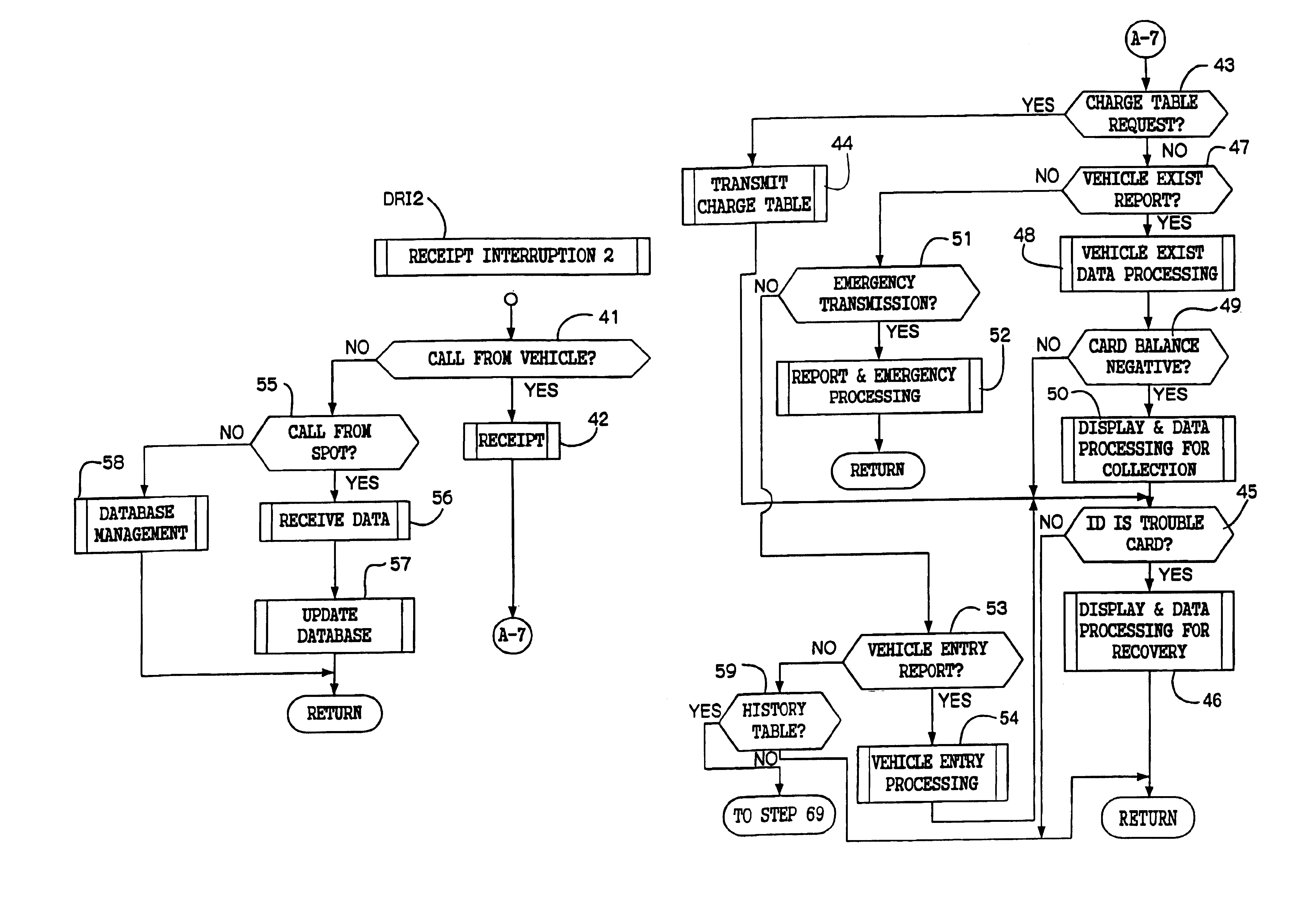
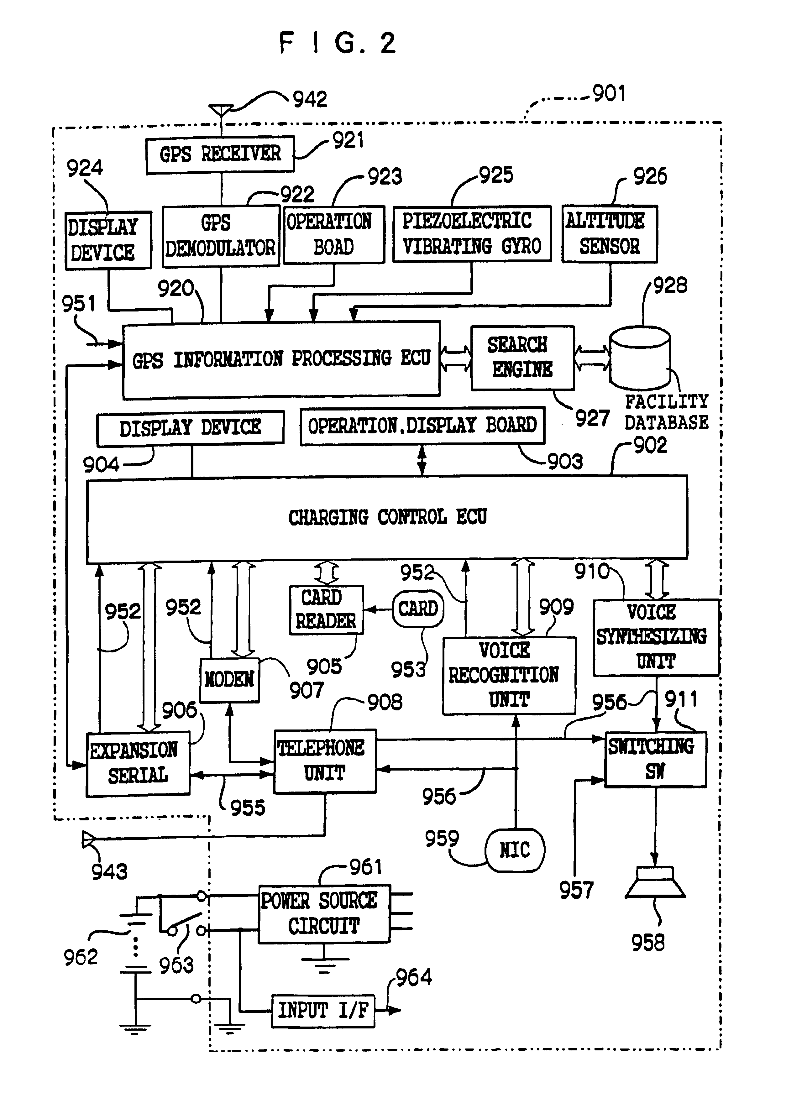
FIG. 1 shows a system structure of an embodiment of the present invention. A vehicle-mounted charging device 901 which is mounted in a vehicle communicates, via a built-in telephone unit 908 (to be described later) and an antenna ANTt (943), with a reporting station 930 (management station) so as to exchange data. Further, radio waves from satellites (941) are received at a GPS antenna ANTg (942), and the position and traveling direction of the vehicle are recognized by a GPS positioning device (920 through 928: to be described later) and are displayed together with a simple map showing the traveling place. In a case in which satellites (941) which can receive are insufficient or receipt of radio waves from the satellites (941) is not possible, the insufficient information is compensated for by vehicle position computation by direction detection using a gyro...


PUM


Abstract

A charging system which carries out position confirmation of a moving body at a place where there is a radio wave blocked facility, and which carries out automatic detection of GPS antenna blockage for avoiding charging. The charging system includes a GPS positioning device for recognizing a vehicle position, a vehicle speed pulse measuring device for dead reckoning navigating, a monitor device which generates information expressing a current position by using these, and a charging processing which judges whether or not a recognized current position is within a charge area and which carries out data processing for charging. The monitor includes a simple map database which includes positions of facilities or geographical features at which GPS positioning is impossible, and when GPS positioning is impossible, the facility or geographical feature corresponding to the current position is detected, and that position is made to be a current position.

Description

TECHNICAL FIELDThe present invention relates to a charging system which carries out data processing for fee payment, when a moving terminal, which is carried by a user or mounted in a moving body, travels through a charge area.BACKGROUND TECHNOLOGYCharging systems have been proposed in which vehicle passing judging devices are set on plural routes on toll roads or the like, and it is judged what route of the plural routes has been traveled. One example thereof is disclosed in Japanese Patent Application Laid-Open (JP-A) No. 9-212794. In this type of conventional technique, at the vehicle passing judging device, it is judged which path of plural paths has been traveled. Then, a traveled distance is specified in accordance with the path, and a fee is charged in accordance with the specified traveled distance. The object of this type of system is to broadly spread such road charging to users of the road and to make traffic smooth. However, in this structure, infrastructure costs are re...

Claims


Application Information

Patent Timeline
Patent Type & Authority Patents(United States)
IPC IPC(8): G01C21/26G07B15/00G08G1/0968G08G1/123G07B15/06
CPCG01C21/26G08G1/207G07B15/063G07B15/00
Inventor FURUTA, YASUYUKIKAKIHARA, MASAKIAOKI, YASUYUKITERADA, HARUHIKO
Owner TOYOTA JIDOSHA KK
Why Eureka
Try Eureka