Method and system for processing positioning signals based on predetermined message data segment

Inactive Publication Date: 2005-04-19
FAST LOCATION NET
View PDF109 Cites 18 Cited by
  • Summary
  • Abstract
  • Description
  • Claims
  • Application Information

AI Technical Summary

Benefits of technology

[0017]Yet another technical advantage of one or more embodiments of the present invention may include the removal of a requirement to integrate a geolocation processing system with the wireless carrier network that provides a communication link between the ranging receiver and an assisting function. Thus, the need for, and the costs associated with, a wireless carrier or plain old telephone system network may be eliminated. For example, support from a carrier's network may not be required to determine a coarse position estimation. In addition, a support network of nearby reference receivers, or its equivalent, would not be required to provide Doppler-shift compensation or Doppler-shift search assistance. An end-to-end frequency-calibration embodiment in the wireless communication link between the receiver and the geolocation processor to allow making use of the Doppler-shift would also not be required.
[0018]Yet another technical advantage of one or more embodiments of the present invention may include the ability to determine the time-of-arrival (TOA) at the ranging receiver of specific segments of the message data having precisely known transmission times from the satellite. The TOA corresponds to the propagation time of the signal from the satellite and the range between the satellite and the ranging receiver. The range of the satellite may be represented by the measurement of the propagation time (or “delay”) of the GPS signal from the satellite to the receiver and comprises: (a) a whole number of milliseconds (epochs); plus (b) a fraction of an epoch (referred to as the pseudorange value), which is typically determined to a precision of about 100 nanoseconds or less (equivalent to a location precision of about 100 feet or less). Conventional GPS receivers only measure the pseudorange portion of the total range delay. They provide no estimate of the number of whole milliseconds of the propagation time, for each satellite, that precedes the final “pseudorange” fraction. This is referred to as “whole number ambiguity” and the navigation algorithms in conventional GPS receivers must resolve the ambiguity by a process of intellige

Problems solved by technology

When satellite signals are received at wireless devices being operated with obstructed views of the sky and thus obstructed line-of-sight, the satellite signals are weakened even further.
Disadvantages associated with this example include a relatively expensive requirement of integration of the network of such receivers with

Method used


Image

  • Method and system for processing positioning signals based on predetermined message data segment
  • Method and system for processing positioning signals based on predetermined message data segment
  • Method and system for processing positioning signals based on predetermined message data segment

Examples


Embodiment Construction

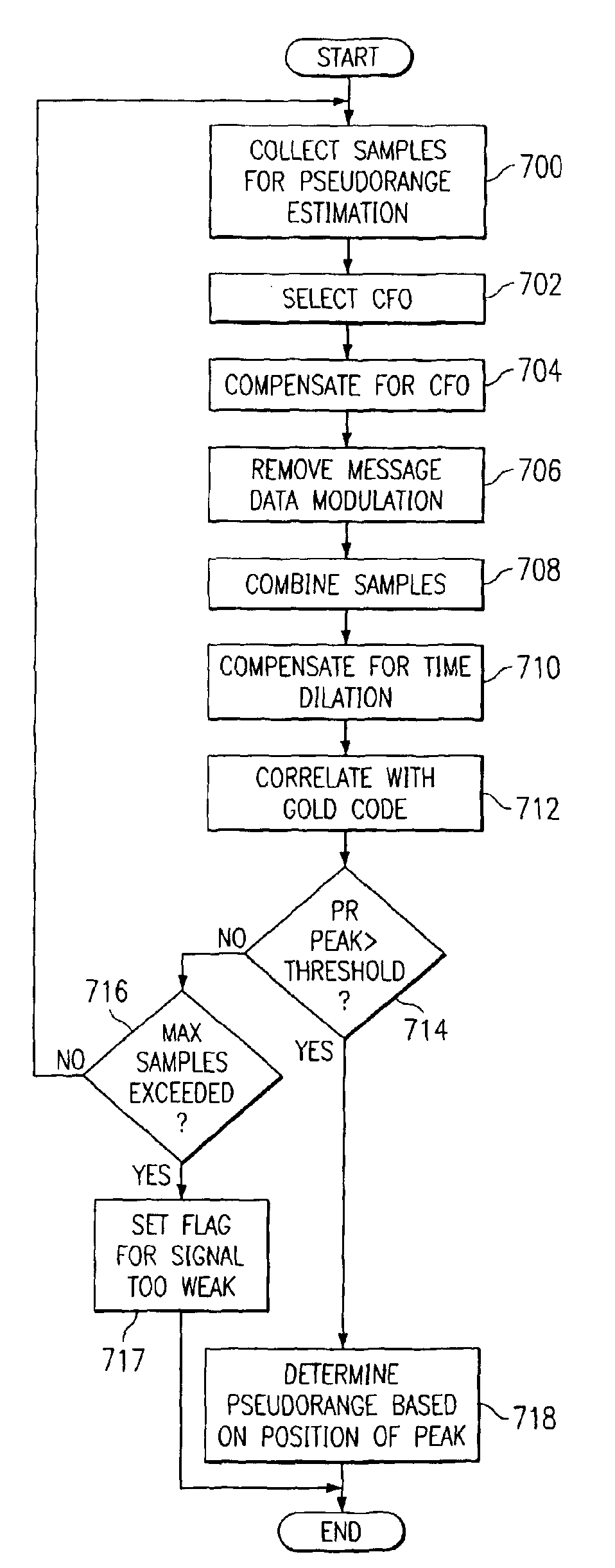
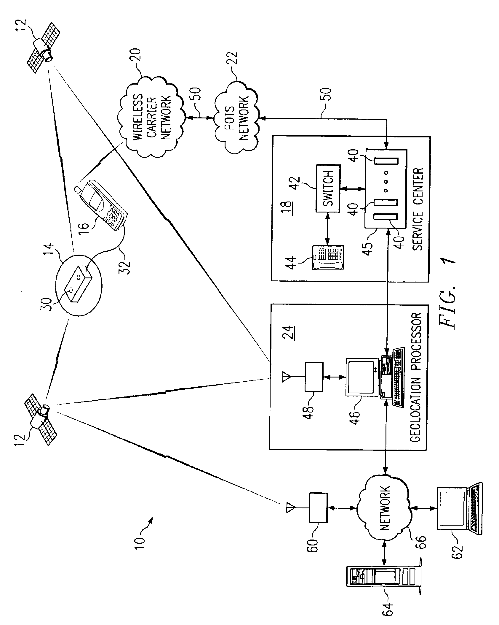
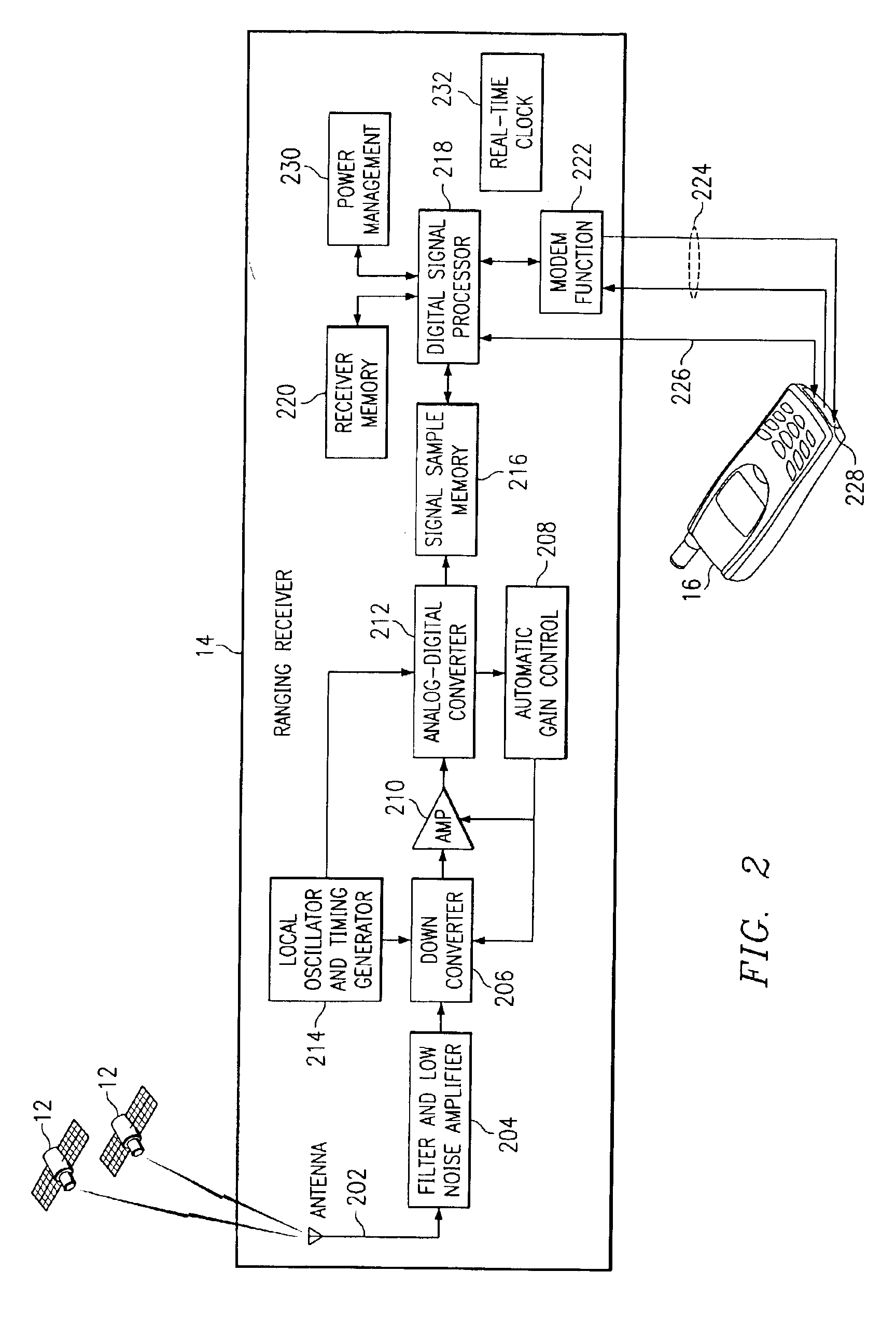
[0041]FIG. 1 is a block diagram illustrating a remote geolocation system 10 in accordance with one embodiment of the present invention. The system 10 may comprise a global positioning system (GPS), a global navigation satellite system (GLONASS), or other suitable navigation system.

[0042]The system 10 comprises a plurality of positioning signal transmitters 12 and at least one ranging receiver 14. The positioning signal transmitters 12 are operable to transmit positioning signals, and each ranging receiver 14 is operable to receive the positioning signals and to perform geolocation processing functions in order to determine a pseudorange estimate for the ranging receiver 14 based on the received signals. As used herein, “each” means every one of at least a subset of the identified items. In the illustrated embodiment, the positioning signal transmitters 12 comprise satellites 12. Thus, as used herein, “satellites” means conventional satellites, pseudolites, or other suitable position...


PUM


Abstract

A method and system for determining a geolocation of an object includes collecting a positioning signal including a predetermined message data segment. A time of arrival of the predetermined message data segment may be determined in the positioning signal. Information based on the time of arrival may be provided for determination of a geolocation of an object. The time of arrival of the predetermined message data segment may be determined based on a time search for the predetermined message data segment in the positioning signal.

Description

RELATED APPLICATIONS[0001]This application is a continuation-in-part and claims the benefit of U.S. patent application Ser. No. 09 / 908,011, entitled “METHOD AND SYSTEM FOR PROCESSING POSITIONING SIGNALS IN A STAND-ALONE MODE”, filed Jul. 18, 2001, now U.S. Pat. No. 6,628,234, and also claims the benefit of U.S. Provisional Patent Application No. 60 / 383,353 filed May 24, 2002, entitled “PROCESSING WEAK SIGNALS FOR PSEUDORANGE WITHOUT MESSAGE ASSISTANCE AND WEAK SIGNAL GPS SATELLITE MESSAGE DECODING.”TECHNICAL FIELD OF THE INVENTION[0002]This invention relates generally to the field of geolocation and more particularly to a method and system for processing positioning signals based on a predetermined message data segment.BACKGROUND OF THE INVENTION[0003]In the application of global positioning system (GPS) technology to the geolocation of wireless devices, a typical geolocation function utilizes a course acquisition (C / A) code, or Gold code, which is received repeatedly from GPS satel...

Claims


Application Information

Patent Timeline
IPC IPC(8): G01S1/00G01S5/00G01S19/25G01S5/14
CPCG01S5/0018G01S5/0063G01S19/05G01S19/235G01S19/256G01S19/29G01S19/254G01S19/09G01S19/17G01S2205/008G01S19/258G01S19/34G01S19/35
Inventor BROMLEY, PATRICK G.JANDRELL, LOUIS H. M.WISE, MICHAEL D.
Owner FAST LOCATION NET
Why Eureka
Try Eureka