Spatially integrated relational database model with dynamic segmentation (SIR-DBMS)

a relational database and dynamic segmentation technology, applied in the field of database management systems, can solve the problem that the SQL statements that implement dynamic segmentation queries can be very complex

Inactive Publication Date: 2005-05-10
LEIDOS
View PDF0 Cites 49 Cited by
  • Summary
  • Abstract
  • Description
  • Claims
  • Application Information

AI Technical Summary

Benefits of technology

[0014]It is therefore provided herein a method and system for providing an open database model that allows the combining of spatial and linear attribute data in a single

Problems solved by technology

SQL statements that implement a dynamic

Method used


Image

  • Spatially integrated relational database model with dynamic segmentation (SIR-DBMS)
  • Spatially integrated relational database model with dynamic segmentation (SIR-DBMS)
  • Spatially integrated relational database model with dynamic segmentation (SIR-DBMS)

Examples


Embodiment Construction

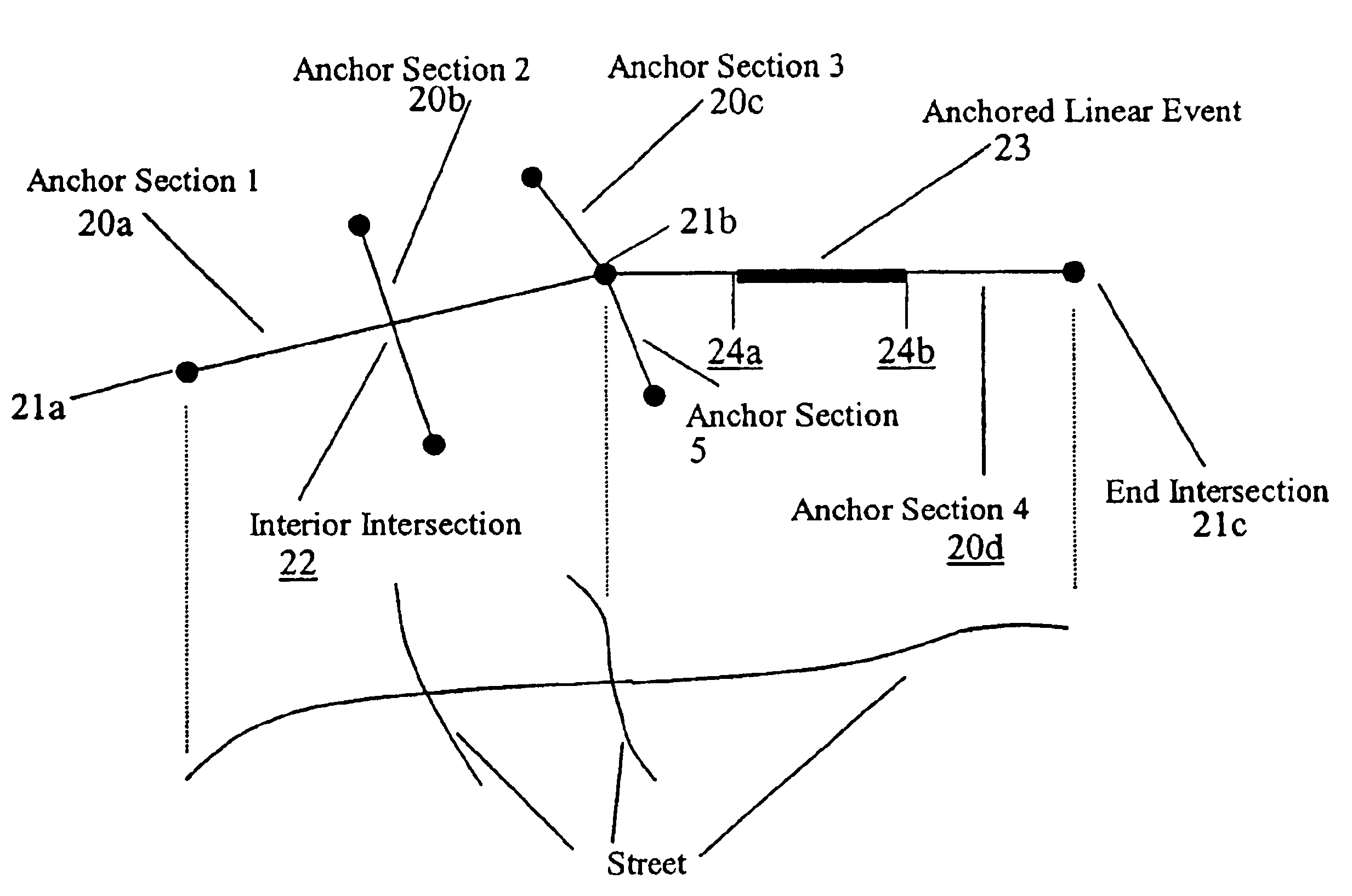
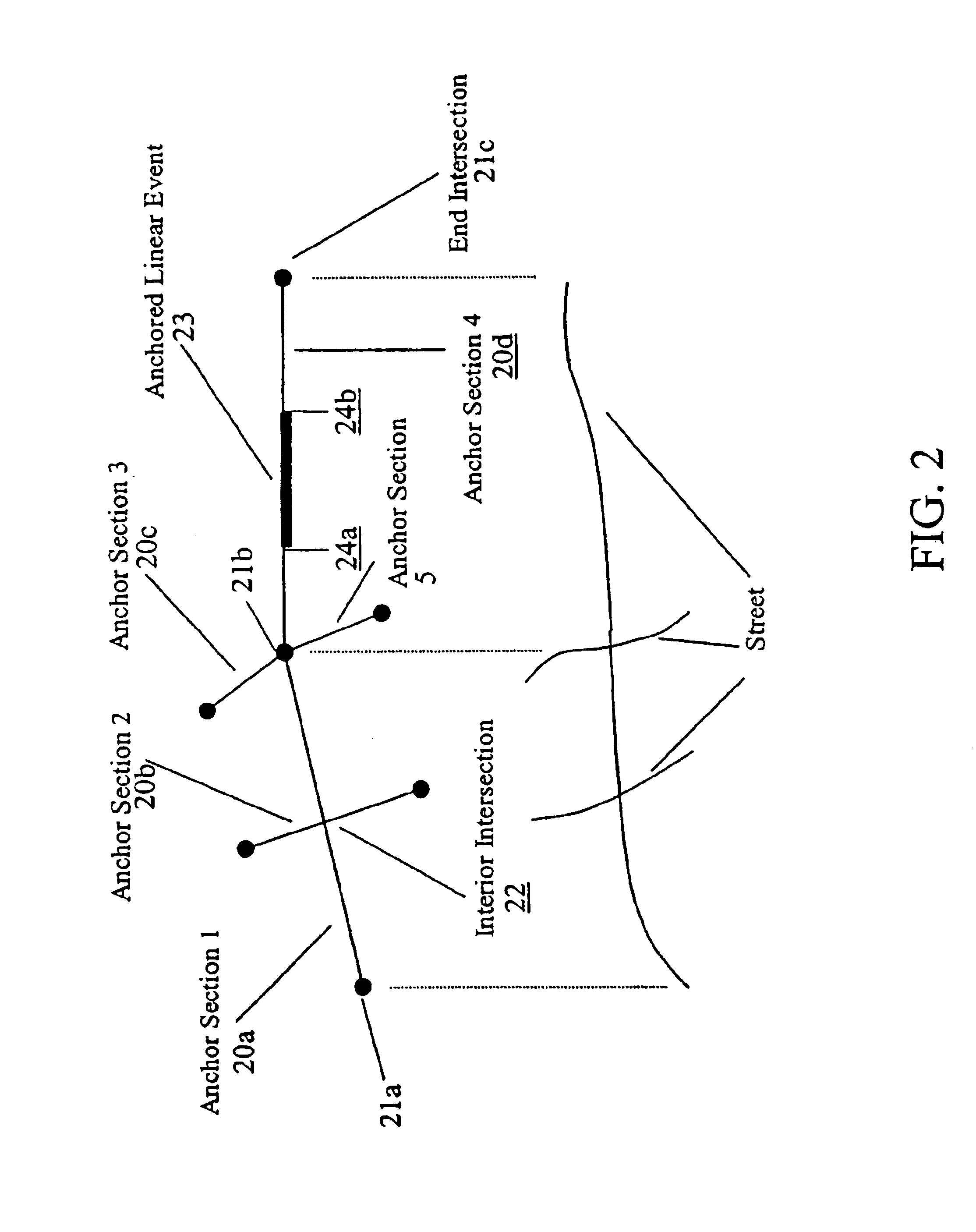
[0041]The present invention is a method and system for providing an open database model that allows the combining of spatial and linear attribute data in a single relational database. The integration of spatial and attribute data allows the data to be accessed by either standard structured query language (SQL) or a GIS viewing application.

[0042]As an exemplary embodiment of the invention, the system and method are herein described in the context of an implementation of a transportation information system (TIS) that meets the afore-mentioned requirements of the Georgia Department of Transportation (GDOT). As such, the system and method described herein will be discussed in the context of an implementation of a core module of the GDOT TIS, specifically a transportation systems and facilities (TSAF) system. It will be apparent to one of ordinary skill in the art how to modify the system and method for integration with other GIS and transportation systems.

[0043]For purposes of the under...


PUM


Abstract

A method and system for providing an open database model that allows the combining of spatial and Attribute data in a single relational database. The integration of spatial and Attribute data allows the data to be accessed by either standard structured query language (SQL) or a GIS viewing application. The invention provides: enhanced performance by avoiding proliferation of segmentation; open dynamic segmentation; integrated temporal data; and automated database maintenance. Permanent anchor sections are provided to define spatial references. The data model allows for intersections in the interior of a link (anchor section), resulting in a more stable form of a link, or anchor section. The use of anchor sections simplifies maintenance of data associated with the anchor sections and facilitates the use of anchor sections in a distributed environment. Database views display data in a simple, tabular format. Access to a continuous archive of historical data is supported.

Description

BACKGROUND OF THE INVENTION[0001]1. Field of the Invention[0002]The present invention relates to database management systems and their use with transportation information systems and spatial geographic information, and more particularly to a spatially integrated relational database using dynamic segmentation for associating linear and spatial information and a method for using the database system with spatial data methods.[0003]2. Description of the Related Art[0004]Commercial relational database management systems have recently provided the ability to store spatial data, but do not support full dynamic segmentation. Commercial graphical information systems (GIS) have provided the ability to store both spatial and relational data, but only in proprietary formats. An anchor section is an underlying spatial referencing mechanism for linear data. In terms of a road network, an anchor section represents a physical section of a roadway, typically a section that connects two intersections...

Claims


Application Information

Patent Timeline
IPC IPC(8): G06F17/00G06F17/30G06F7/00
CPCG06F17/30241G06F17/30557Y10S707/99931G06F16/29G06F16/25
Inventor HAAS, ROBERT P.ROBERTSON, STEPHEN H.
Owner LEIDOS
Why Eureka
Try Eureka