Navcell pier to pier GPS

a technology of pier to pier, applied in the field of marine navigation systems, to achieve the effect of enhancing navigation safety and high degree of accuracy

Inactive Publication Date: 2005-06-07
S AQUA SEMICONDUCTOR LLC
View PDF43 Cites 61 Cited by
  • Summary
  • Abstract
  • Description
  • Claims
  • Application Information

AI Technical Summary

Benefits of technology

[0005]The object of this invention is to provide a GPS-based navigation system for determining the location of a vessel with a high degree of accuracy coupled with a wireless communication system for determining a vessel's posit...

Problems solved by technology

Due to the lack of fixed landmarks and pathways marine navigation, positioning and hazard avoidance has historically been a problem of great importance.
However, even with the u...

Method used


Image

  • Navcell pier to pier GPS
  • Navcell pier to pier GPS
  • Navcell pier to pier GPS

Examples


Embodiment Construction

[0013]There will be detailed below the preferred embodiments of the present invention with reference to the accompanying drawings. Like members are designated by like reference characters in all figures.

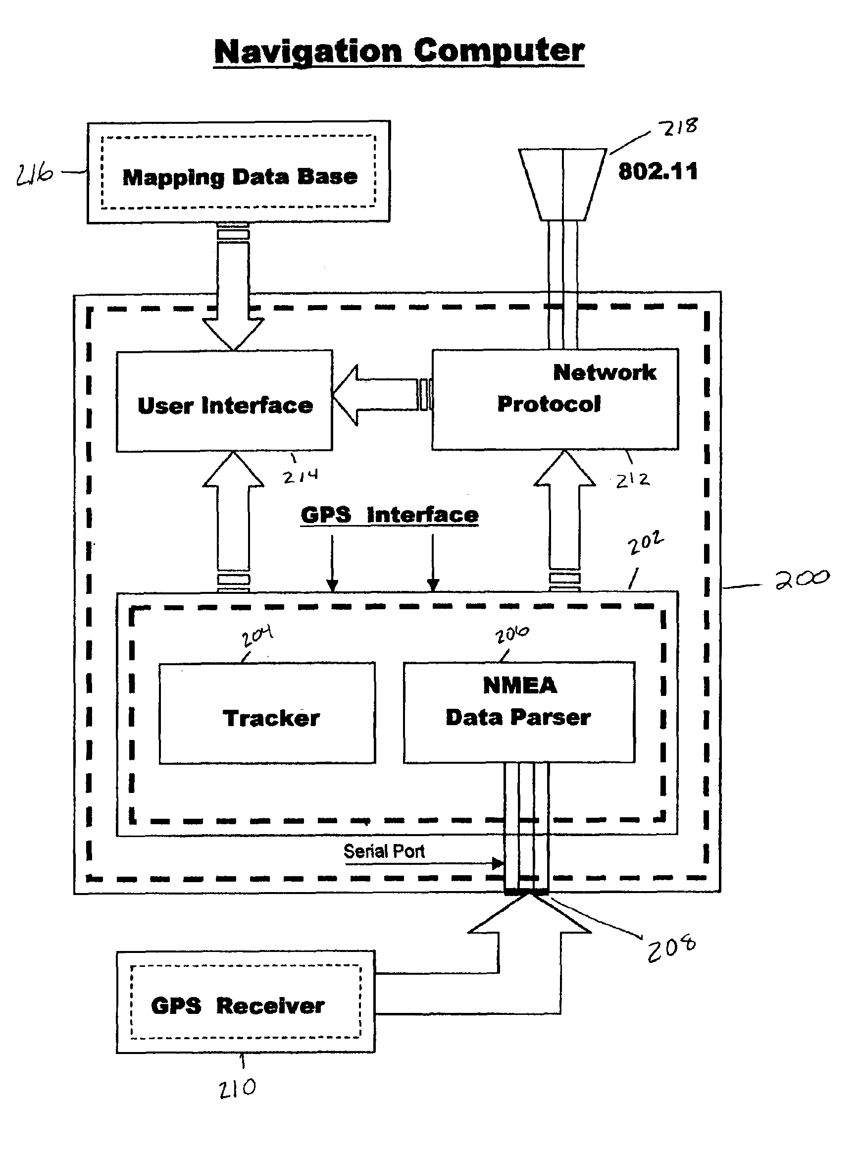
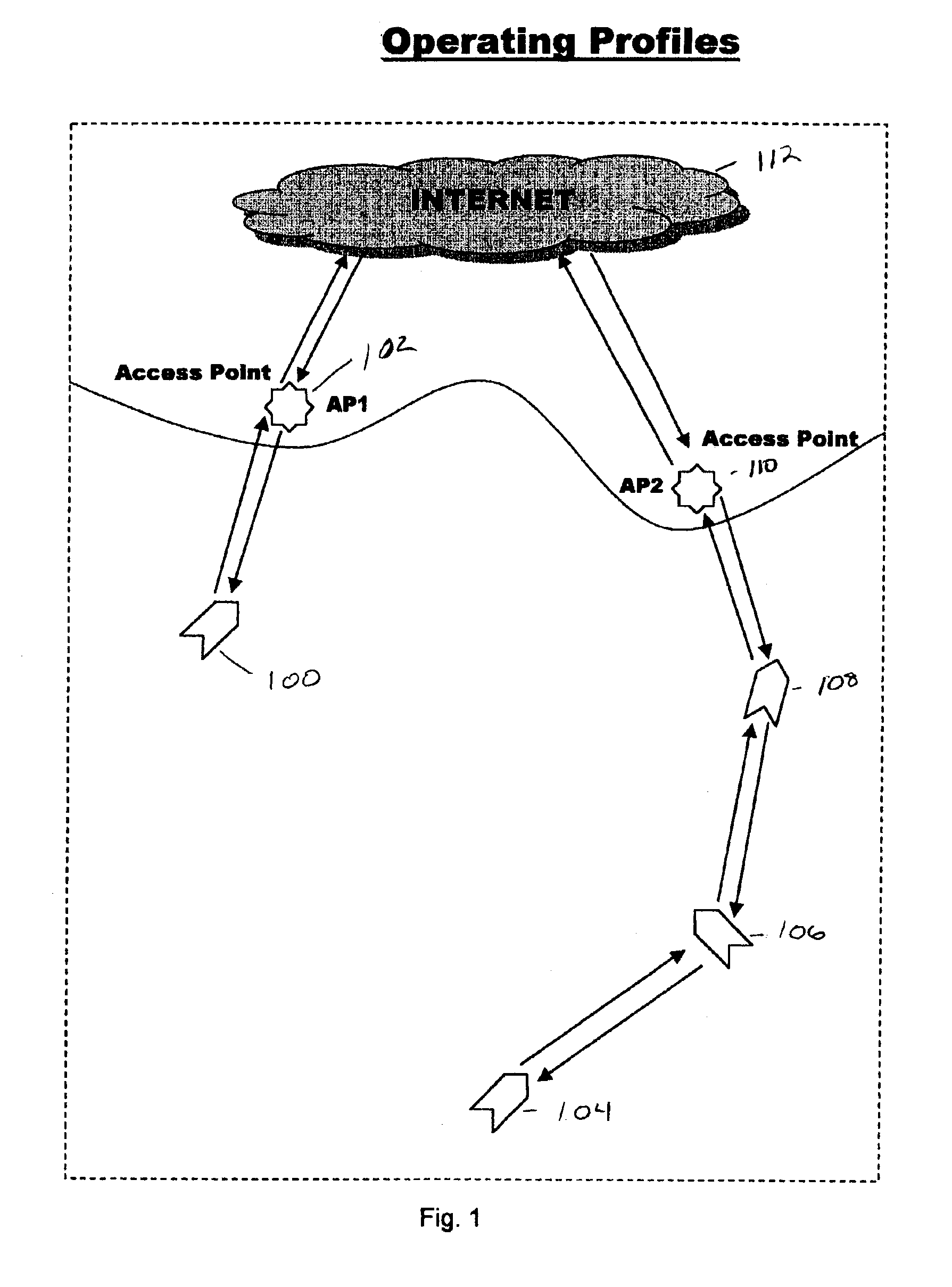
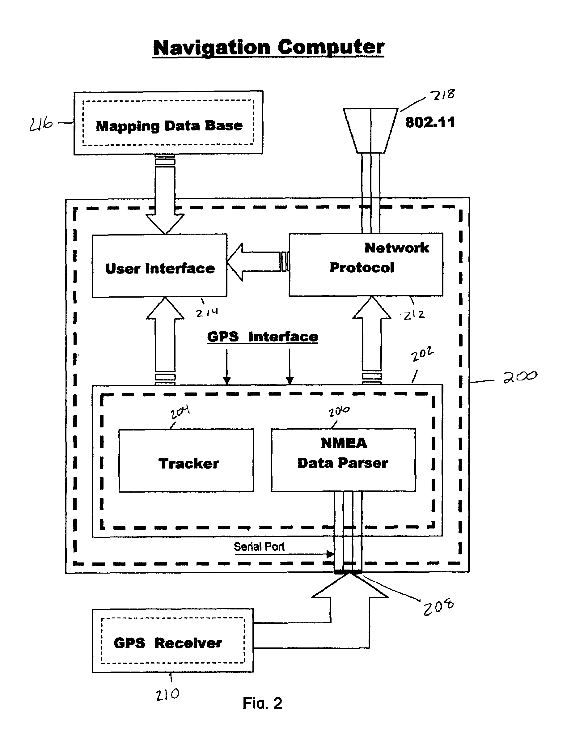
[0014]FIG. 1 depicts an exemplary operating profile according to the present invention. The present invention includes a plurality of navigation systems wherein each navigation system includes a GPS system, together with a wireless network communications system. In this exemplary embodiment, the GPS data is formatted in the National Marine Electronics Association (NMEA) format, however it will be understood that other formats may be used for alternate embodiments of the present invention. The navigation system according to the present invention is deployed on a plurality of vessel located on a body of water such a lake, river, or ocean. The navigation system of each vessel is linked by way of a wireless mesh network, which communicates the position of all vessels to one another. In t...


PUM


Abstract

The present invention is directed to, a navigation system comprising; a plurality of GPS-receivers having GPS antennas mounted thereto for receiving GPS signals, a data processing apparatus for processing GPS signals and determining location data, a wireless network transmitting and receiving apparatus connected to the data processing apparatus for transmitting and receiving the location data from the plurality of GPS-receivers, and a display device for displaying the location data.

Description

CROSS REFERENCE TO RELATED APPLICATION[0001]This application claims the benefit of priority on U.S. Provisional Application No. 60 / 319,162 Filed Apr. 2, 2002, entitled NAV-CELL PIER TO PIER GPS and U.S. Provisional Application No. 60 / 319,769 Filed Dec. 11, 2002 entitled MARINE GPScell.FIELD OF THE INVENTION[0002]This invention relates in general to marine navigation systems and more particularly to marine navigation systems having the capability of wireless mesh networking, with each other and with other private and public access points, for the purpose of navigation, collision avoidance, and communication.BACKGROUND OF THE INVENTION[0003]Due to the lack of fixed landmarks and pathways marine navigation, positioning and hazard avoidance has historically been a problem of great importance. Throughout history, may devices and methods have been utilized to provide a mariner with accurate information concerning his location as well as the location of moving and stationary surroundings. ...

Claims


Application Information

Patent Timeline
IPC IPC(8): G01C21/00G01S5/00
CPCG01C21/00G01S5/0009G01S5/0072G01S5/0027G01S2205/002G01C21/3885
Inventor RANDAZZO, WILLIAM S.ROSE, JONATHAN M.RANDAZZO, RICHARD A.
Owner S AQUA SEMICONDUCTOR LLC
Why Eureka
Try Eureka