Method and device for predicting the course of motor vehicles

a technology for predicting the course of a motor vehicle and a device, which is applied in the direction of navigation instruments, instruments, scene recognition, etc., can solve the problem of not being able to decide on the basis of tracking data alone which stationary target type has been detected, and achieve the effect of accurate path prediction and minor processing complexity

Active Publication Date: 2012-02-28
ROBERT BOSCH GMBH
View PDF27 Cites 11 Cited by
  • Summary
  • Abstract
  • Description
  • Claims
  • Application Information

AI Technical Summary

Benefits of technology

[0009]An object of the present invention is to provide a method for travel course prediction which permits a relatively accurate prediction of the path of the road with relatively minor processing complexity.
[0013]One advantage of this method is that it is based essentially on localized stationary targets which are characterized by a relatively high amplitude in the radar echo and therefore may be tracked accurately and reliably. This yields a method that is very stable with respect to interfering influences. In general, at a given point in time only a limited number of such local stationary targets will be located within the tracking range of the radar, so the analysis may be accomplished with a justifiable computation effort. Another important advantage is that the stationary targets may be tracked over a plurality of measuring cycles, so that the multitude of objects analyzed in a given measuring cycle is already known from previous measuring cycles. Consequently, it is possible to rely on previous results in classifying these objects as roadside targets or interfering objects.
[0027]In another embodiment of the method, which is referred to as a “statistical method,” it is not necessary to classify the stationary targets individually as interfering objects or as roadside targets and to assign them to a certain side of the road. The plausibility criterion here is that the curvature of the road obtained for various combinations of stationary targets shows a significant accumulation at that “correct” curvature. The effects of interfering objects are thus eliminated by the statistical analysis in this method.
[0030]To increase accuracy, the error range of the measured data for the individual stationary targets may be taken into account in the statistical analysis, so that curves based on more accurately measured objects (objects in closer proximity) are weighted more heavily.

Problems solved by technology

It is impossible to decide on the basis of the tracking data alone which type of stationary target has been detected.
However, since the stationary targets used as interpolation points may also be interfering objects which are not actually on the roadside, roadside shapes which differ greatly from the true roadside shape may also be obtained, depending on the choice of the interpolation points.

Method used


Image

  • Method and device for predicting the course of motor vehicles
  • Method and device for predicting the course of motor vehicles
  • Method and device for predicting the course of motor vehicles

Examples


Embodiment Construction

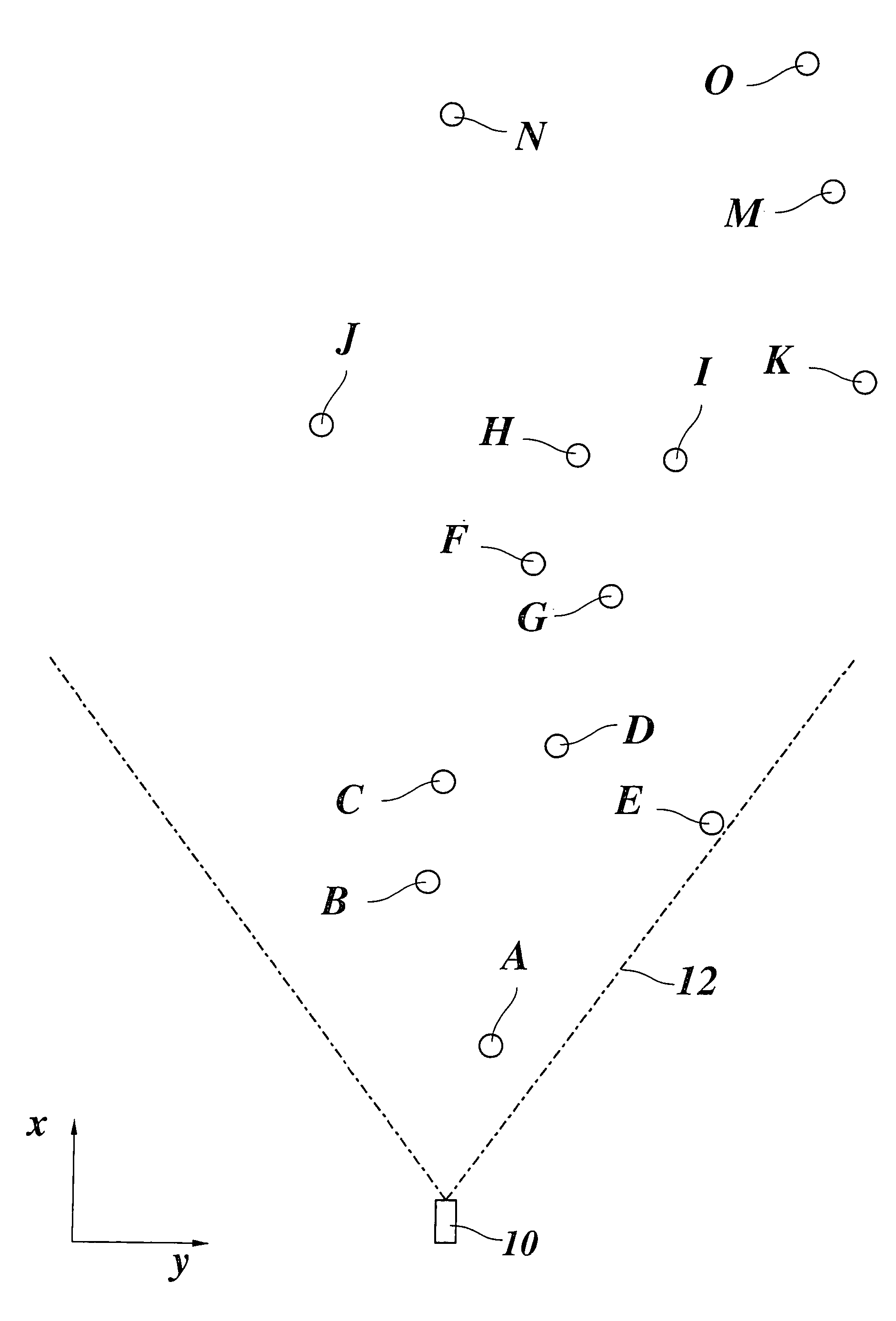
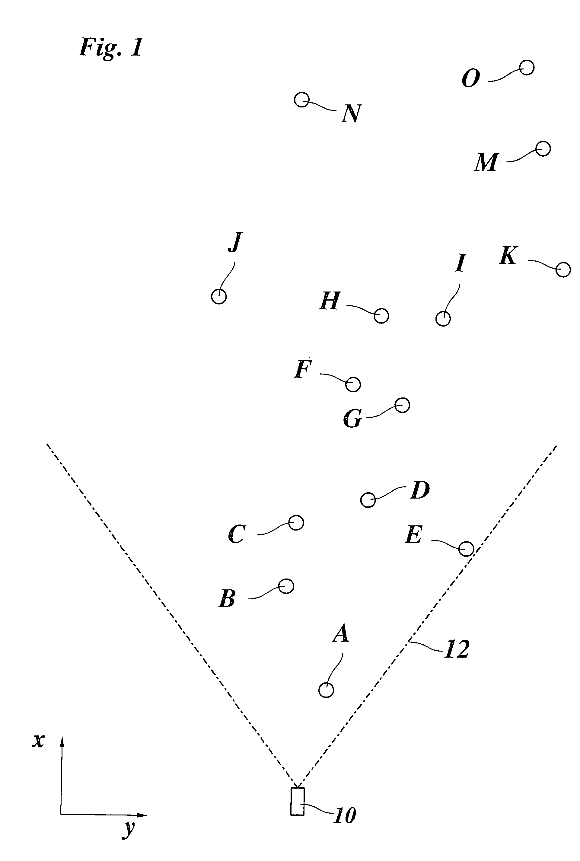
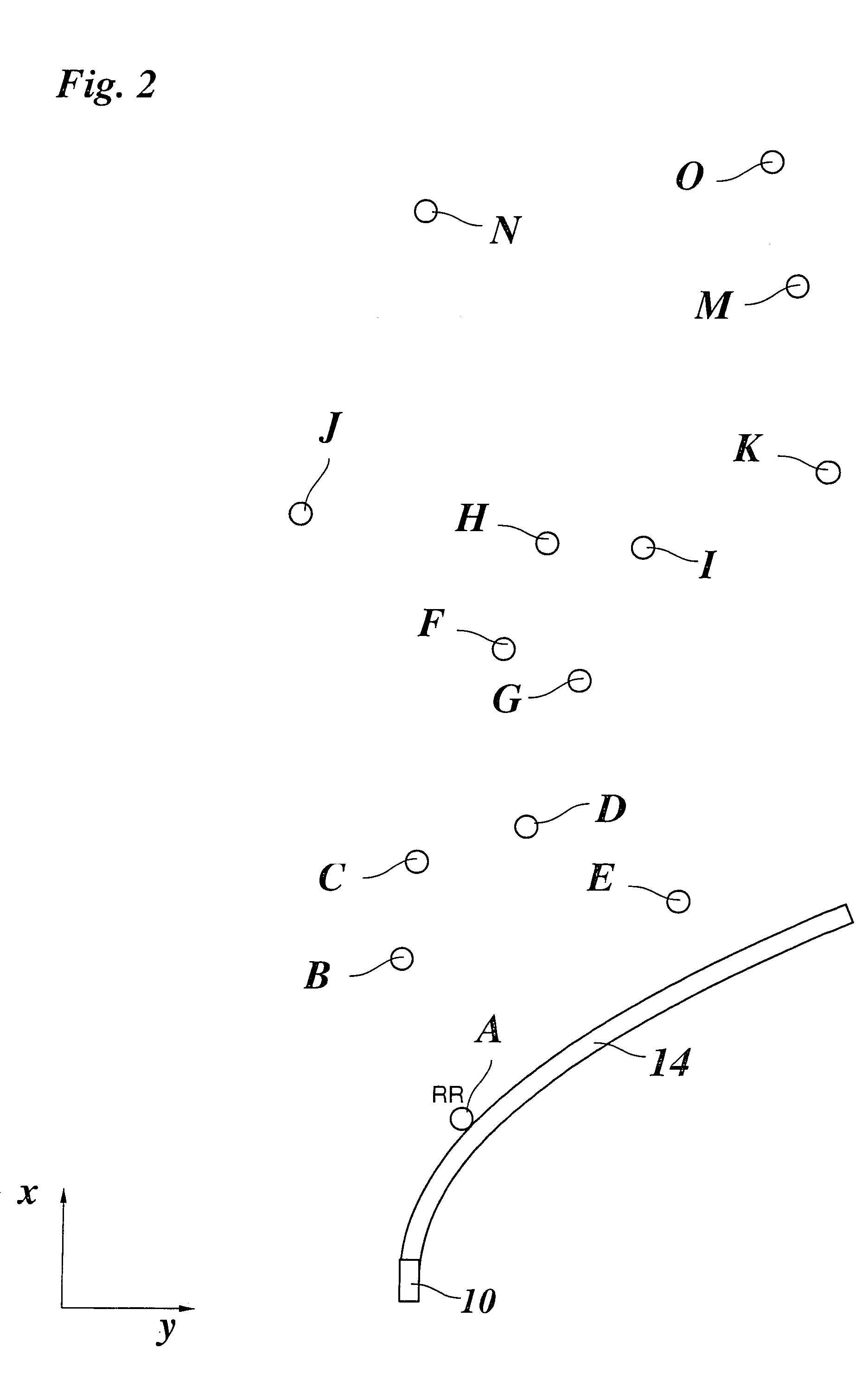
[0045]FIG. 1 shows a top view of a vehicle 10 which is equipped with an ACC system. The ACC system includes a radar sensor as a tracking sensor. Tracking angle range 12 of the radar sensor is indicated with dash-dot lines. The direction of travel of vehicle 10 is indicated by an arrow x. The direction perpendicular to the direction of travel is labeled as y.

[0046]In the tracking range of the radar sensor there are multiple objects A-O which have been identified as stationary targets because their relative speed in relation to vehicle 10 is equal to the speed of vehicle 10 but in the opposite direction. The coordinates (x, y) have been measured for each of objects A-O with the help of the radar system which has angular resolution. The object now is to determine the forecasted path of the road on the basis of the positions of objects A-O, a few of which are located on the roadside but others are beyond the roadside. To this end, functions indicating the shape of the right and left sid...


PUM


Abstract

A method for travel course prediction in a motor vehicle having a position finding system for objects situated ahead of the vehicle is provided. In accordance with the method, a function describing the shape of the roadside is calculated on the basis of measured distance data and angle data for stationary roadside targets, wherein multiple stationary targets are identified and tracked. The path of the road is estimated for various subsets of the set of tracked stationary targets, under the assumption that these stationary targets are situated along the roadside, and roadside targets are differentiated from interfering objects on the basis of the plausibility of the resulting possible shapes of the roadside, the most probable shape of the roadside being determined on the basis of the roadside targets.

Description

FIELD OF THE INVENTION[0001]The present invention relates to a method and a device for travel course prediction in motor vehicles having a position finding system for objects situated ahead of the host vehicle, in which a function describing the shape of the roadside is calculated on the basis of the measured distance and angle data for stationary targets on the roadside. The present invention in particular relates to a method for travel course prediction in conjunction with an ACC system (Adaptive Cruise Control) which is used to regulate the distance between the host vehicle and a lead vehicle located with the help of a position finding system so that the lead vehicle is followed at a suitable safety distance.BACKGROUND INFORMATION[0002]Modern vehicles are often equipped with a driver assistance system which supports the driver in driving the vehicle and facilitates the execution of certain driving maneuvers. To this end, the driver assistance system requires information about the...

Claims


Application Information

Patent Timeline
Patent Type & Authority Patents(United States)
IPC IPC(8): G01C21/00G06F17/00B60R21/00G01S13/931G06T7/20G08G1/16
CPCG01S13/931G06K9/00805G06T7/20B60W2550/10G01S2013/9339Y02T10/84G01S2013/9325G01S2013/9353G01S2013/9329G01S2013/932B60W2554/00G06V20/58B60W2554/80B60W2554/20
Inventor WINNER, HERMANNURBAN, WERNERLUEDER, JENSMAASS, ALEXANDER
Owner ROBERT BOSCH GMBH
Why Eureka
Try Eureka