System and method for generating derived products in a radar network

a radar network and derived product technology, applied in the direction of climate sustainability, instruments, measurement devices, etc., can solve the problem that the most accurate network based velocity measurement is not always the most accurate, geometrically efficient dual-doppler retrieval, etc., to improve numerical weather models' skill, improve system resource utilization, and low velocity field appreciation

Active Publication Date: 2013-09-03
UNIV OF MASSACHUSETTS
View PDF59 Cites 6 Cited by
  • Summary
  • Abstract
  • Description
  • Claims
  • Application Information

AI Technical Summary

Benefits of technology

[0006]Prior studies demonstrate the added value and importance of high-quality and high-resolution vector velocity field data for making improvements in the skill of numerical weather models to predict severe weather phenomena. In addition to provision of velocity estimates, it is desired to have a metric to gauge the quality of the estimates. This metric can be used to classify data, so that numerical weather prediction class of CASA end-users can be informed about the derived velocity data's quality. Further, estimates of the velocity data quality can aid in the planning of radar scanning strategies for the next observing period or scan interval. CASA's scanning strategy is to scan when and where end-user needs are greatest. The current design deployed in the IP1 system allows end-users to define their needs in terms of what to scan and how to scan it. Feature detection algorithms, continuously running on streamed data, report what weather objects are detected. Based on this information, end-user rules define the frequency and the regions for future scans.
[0007]Thus, the present invention is utilized in the process of selecting the observing radars performing the observation, which is largely determined by a function maximizing the number of objects that the system is able to scan during a predetermined heartbeat interval, currently set to one minute for many scanning operations. In the case of velocity retrievals, in addition to the previous steps, two or more radars are chosen in such a way as to provide a geometrically efficient dual-Doppler retrieval and scan coordination to satisfy sufficient coincident temporal sampling. However, a geometrically efficient dual-Doppler retrieval does not necessarily provide the most accurate network based velocity measurements. Use of quality metrics from previous scans can be used to compare the quality of competing scans; hence, increasing the utilization of system resources.
[0008]One of the CASA user groups are the emergency managers whose responsibility is to issue public warnings about the weather related emergencies and hazards. Some of CASA's data outputs, such as reflectivity and radial velocity, are streamed directly to emergency managers to assist in their decision making process. Currently, emergency managers foremost desire is the output of base reflectivity, valuing its utility to be 68% of the whole. The composite reflectivity was valued at 20% and then radial velocity at 5%. Because weather related emergencies and hazards are usually manifested with strong velocity signatures, a low appreciation of velocity fields by end-users is surprising. One possible explanation for the underutilization of velocity data is that it is one-dimensional and presented in polar coordinates, which requires additional skills to interpret. If true, improvements in the display of vector velocity fields to emergency managers will be better utilized, and the use of CASA velocity data will be increased.
[0009]Thus the present invention provides real-time vector velocity measurement and display, which delivered along with quality metrics, assist in a better understanding of the radar network performance and help maximize the utilization of limited network resources. While existing techniques can be used to provide vector velocity, they are limited in that they do not provide velocity measurements in real time, i.e. within the short scan interval time needed to quickly adjust to changing conditions, nor do they provide quality metrics or are not configured or scalable for distributed networks of small radar systems. The present invention provides a operational real-time solution for the estimation of vector velocity and other related products in radar network (e.g. CASA's Integrative Project One system—IP1) which is flexible and scalable to address other radar network configurations, not yet in existence.
[0010]A preferred embodiment includes a network of velocity processors, each processor associated with a different plurality of radar nodes to provide for the selection of different networked processing combinations for improved resolution and scaling. A network control system allocates the use of this velocity processor network to provide networked three dimensional (3D) velocity measurements. The velocity processors operate in real time, i.e. they compute velocity values within the scan intervals or heartbeat at which the radar nodes operate and quantitatively characteristize the resulting velocity data using metrics to indicate for the end user the quality of the measurement being made. The system uses a geo-centric spherical coordinate system to improve computational efficiency and speed. The quality metric can be defined in terms of the signal to noise ratio (SNR) and spectral width.

Problems solved by technology

However, a geometrically efficient dual-Doppler retrieval does not necessarily provide the most accurate network based velocity measurements.

Method used


Image

  • System and method for generating derived products in a radar network
  • System and method for generating derived products in a radar network
  • System and method for generating derived products in a radar network

Examples


Embodiment Construction

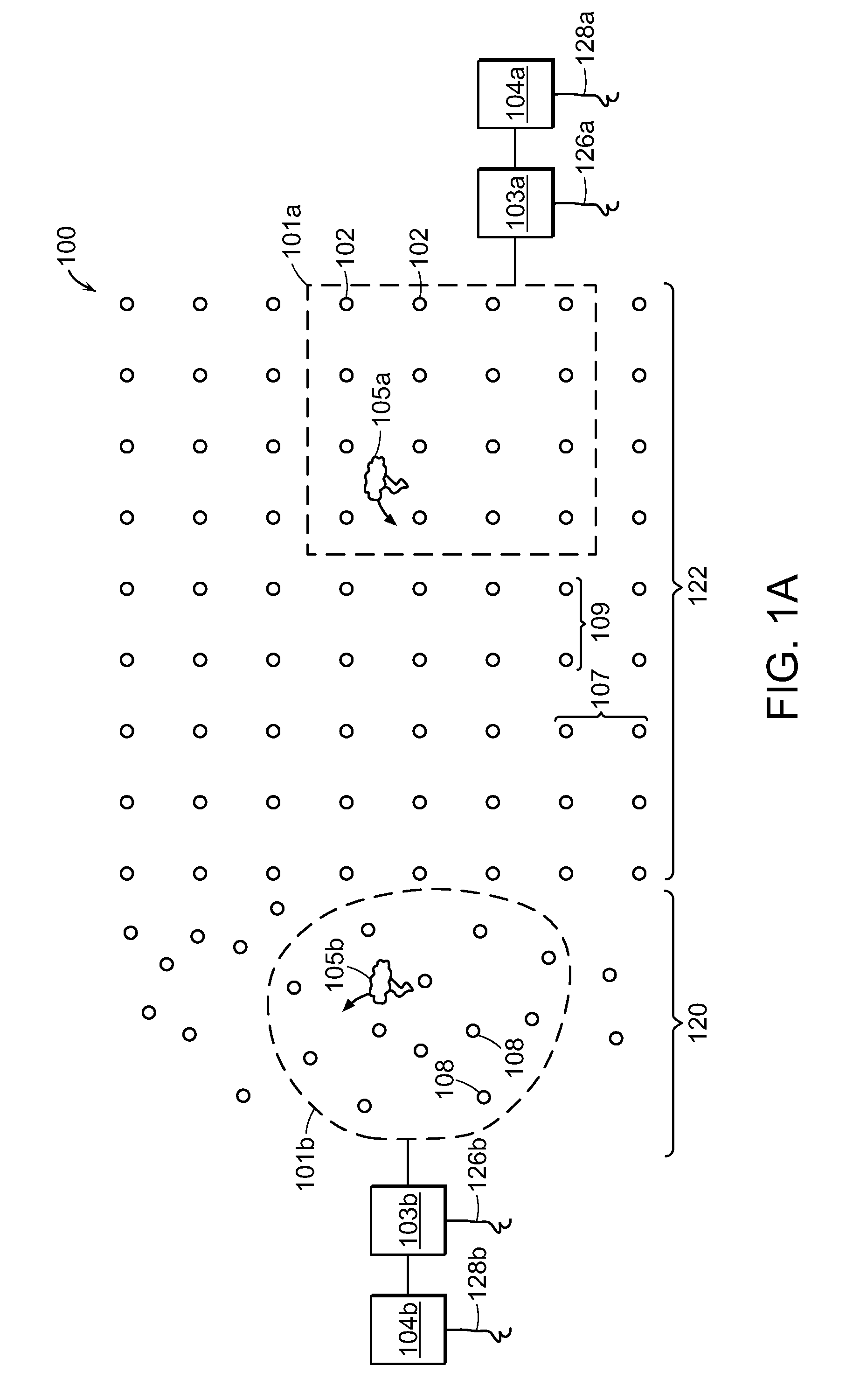
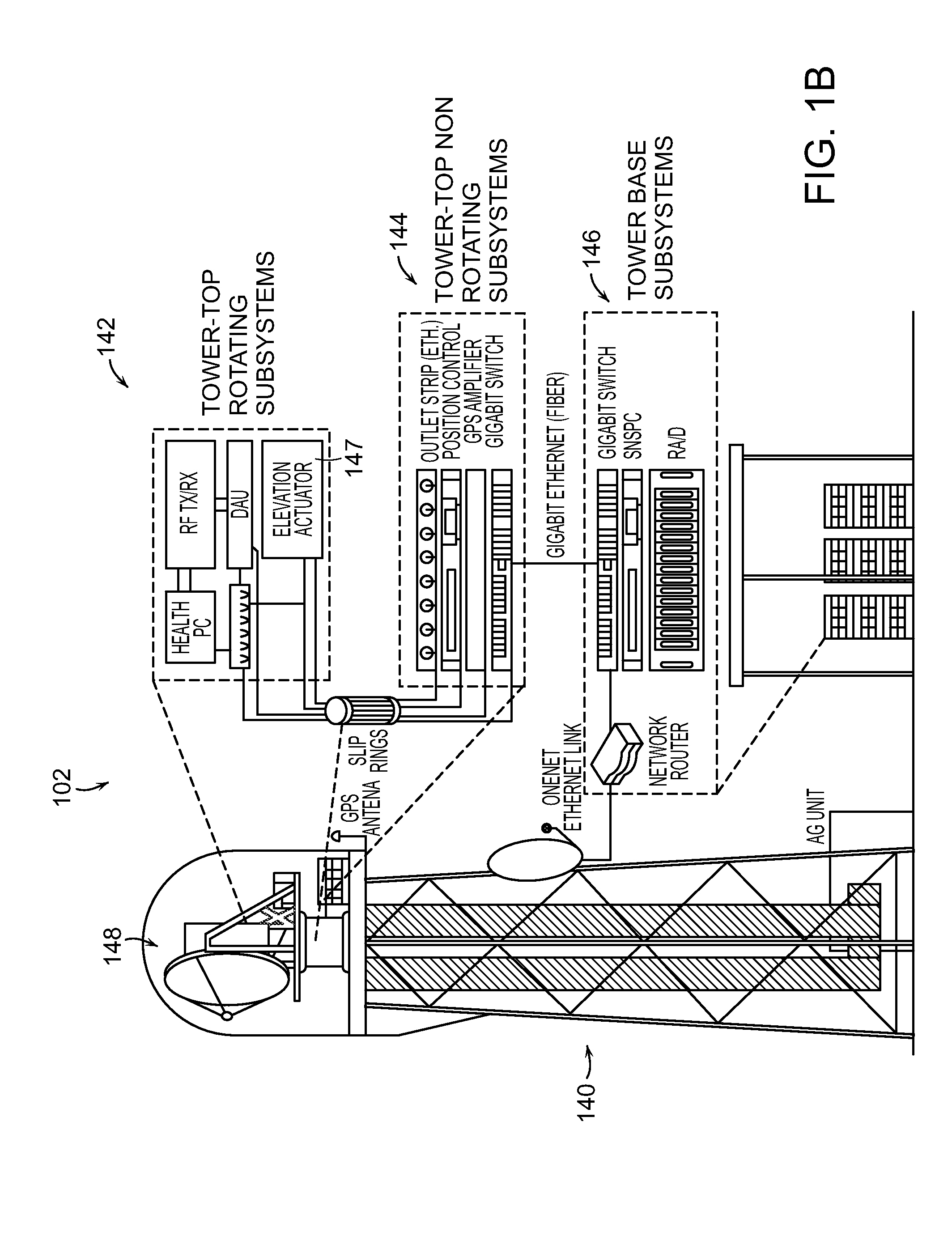
[0044]FIGS. 1A-1D illustrate a system 100 according to a preferred embodiment of the invention. In a preferred embodiment, the methods and systems of the invention operate in conjunction with a radar network that includes a plurality of nodes 102 that can operate collaborating in distinct regions or groups.

[0045]FIG. 1A illustrates a radar system 100 comprising a plurality of radar stations or “nodes”102 covering a wide geographic area. In one embodiment, each of the radar nodes 102 operates at relatively short range, communicates with other nodes over a communications network, such as an Ethernet network and / or the internet, and adjusts its sensing strategy in response to evolving weather and changing user needs.

[0046]In this embodiment, the system 100 is divided into one or more smaller networks regions 101a, 101b, each comprised of a subset of nodes 102 operating in coordination with one another under the control of a command and control processor 103a, 103b. The command and cont...


PUM


Abstract

The present invention relates to systems and methods of measuring atmospheric conditions using networked radar systems. A processor receives sensed data from the radar nodes of the network to determine weather conditions within the atmospheric region measured by network. Preferred embodiments use a velocity processor to determine the velocity of the atmosphere in real time for display.

Description

STATEMENT REGARDING FEDERALLY SPONSORED RESEARCH OR DEVELOPMENT[0001]This invention was supported, in whole or in part, by the Engineering Research Centers Program of the National Science Foundation under grant number EEC-0313747. The government has certain rights in this invention.BACKGROUND OF THE INVENTION[0002]The center for Collaborative Adaptive Sensing of the Atmosphere (CAS A), an NSF Engineering Research Center, was established in 2003 to develop low-cost, high spatial density networks of weather Doppler X-band radars for sensing the lower atmosphere. This radar network system is formed on a Distributed Collaborative Adaptive Sensing (DCAS) paradigm based on a large number of small radars operating collaboratively within an information technology infrastructure to measure changing atmospheric conditions. The allocation and configuration of radar system resources within the DCAS network is based on a balance between the priority and type of user requests and the desired qual...

Claims


Application Information

Patent Timeline
Patent Type & Authority Patents(United States)
IPC IPC(8): G01S13/95
CPCG01S7/003G01S13/951Y02A90/10
Inventor INSANIC, EDINSIQUEIRA, PAUL
Owner UNIV OF MASSACHUSETTS
Why Eureka
Try Eureka