Methods for performing soil measurements including defining antenna configuration based on sensor burial depth

a sensor and burial depth technology, applied in the field of wireless subsurface sensors, can solve the problems of not being able to adapt their tuning in close to real time to the soil conditions, being difficult to close the underground to above ground rf communication link, and being unable to overcome certain wireless sensing devices, so as to optimize the utilization of resources, optimize turf health and playability, and improve product quality

Active Publication Date: 2014-03-25
GREEN BADGE
View PDF18 Cites 17 Cited by
  • Summary
  • Abstract
  • Description
  • Claims
  • Application Information

AI Technical Summary

Benefits of technology

[0026]In such conditions, where information about soil moisture and salinity conditions at the time of attempted transmission is available to the wireless sensor, for example when there are on board moisture and conductivity sensor present, the wireless transmitter will perform a simple computation to determine whether its transmission will be successful given the network activity history and the soil moisture and conductivity levels. The wireless sensor will track the moisture and conductivity levels, and based on those levels will adjust its transmission attempts. The impact of this decision making is that it will predict when the transmission will fail, and thus refrain from transmitting. This adaptive adjustme

Problems solved by technology

Closing an underground to above ground RF communication link is a challenging task.
The challenge is typically due to difficult propagation conditions perpetrated by high water content as well as high conductivity in the soil.
However, in some instances it may not be possible to overc

Method used


Image

  • Methods for performing soil measurements including defining antenna configuration based on sensor burial depth
  • Methods for performing soil measurements including defining antenna configuration based on sensor burial depth
  • Methods for performing soil measurements including defining antenna configuration based on sensor burial depth

Examples


Embodiment Construction

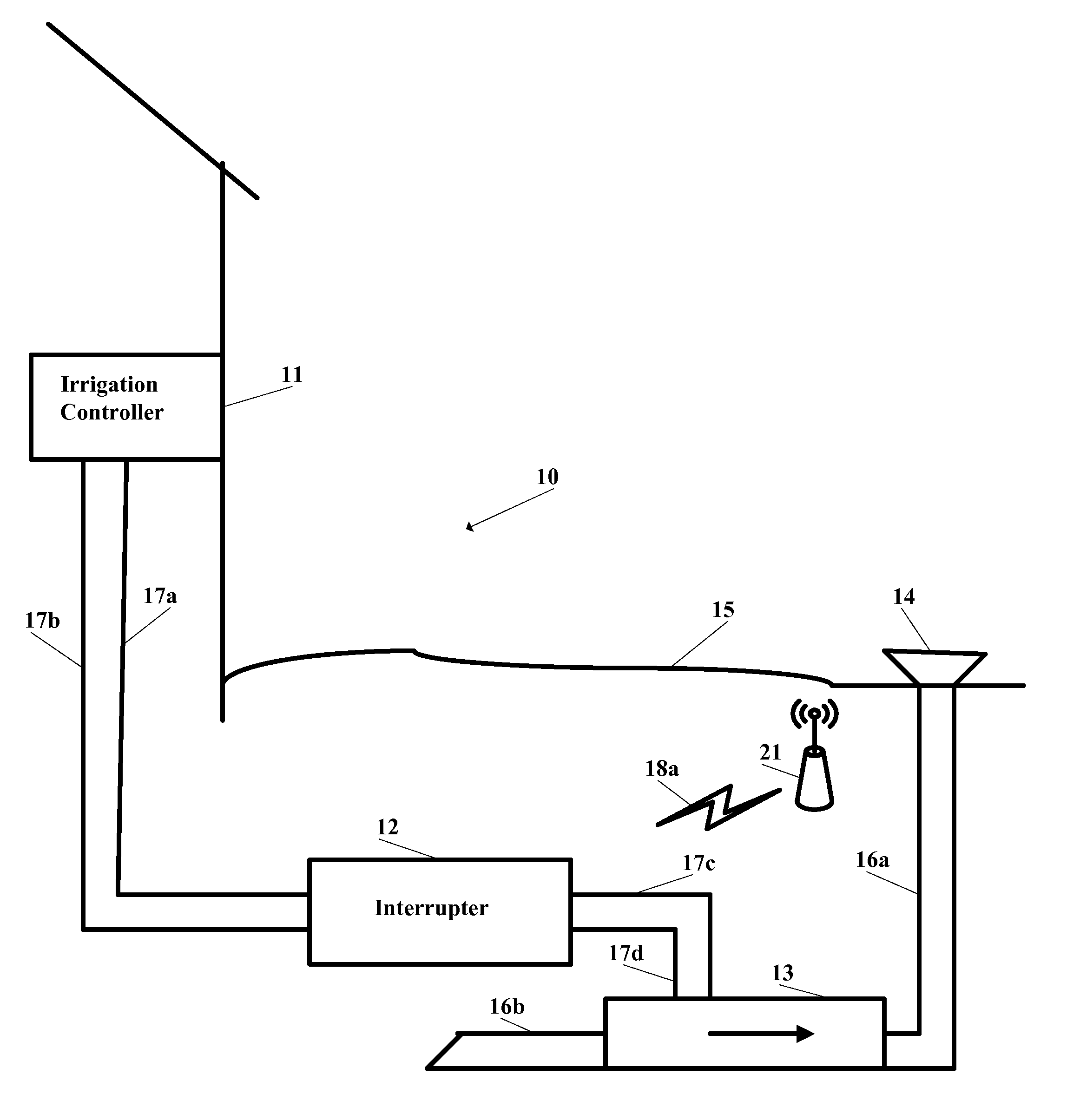
[0068]The present invention is preferably used with a system and method such as disclosed in Glancy, et al., U.S. Patent Publication Number 2006 / 0178847 for an Apparatus And Method For Wireless Real Time Measurement And Control Of Soil And Turf Conditions, which is hereby incorporated by reference in its entirety.

[0069]The present invention may be used with a system, sensor and method such as disclosed in Campbell, U.S. Pat. No. 7,482,820 for a Sensor For Measuring Moisture And Salinity, which is hereby incorporated by reference in its entirety. The present invention may use a chemical sensor probe such as disclose in U.S. Pat. No. 4,059,499 which is hereby incorporated by reference in its entirety. The present invention may use a chemical sensor probe such as disclose in U.S. Pat. No. 5,033,397 which is hereby incorporated by reference in its entirety. Systems and methods for optimizing irrigation are disclosed in Magro et al., U.S. patent application Ser. No. 12 / 697,226, filed on ...


PUM


Abstract

A method for prescribing action to maintain a land area within a predetermined performance zone is disclosed herein. The method results in prescribing an action for the land area. The method measures soil salinity, soil temperature, soil moisture, air temperature, soil pollutant content, soil nutrient content, and the like.

Description

CROSS REFERENCE TO RELATED APPLICATION[0001]The present application is claims priority to U.S. Provisional Patent Application No. 61 / 149,692, filed on Feb. 2, 2009, U.S. Provisional Patent Application No. 61 / 149,028, filed on Feb. 2, 2009, and U.S. Provisional Patent Application No. 61 / 149,330, filed on Feb. 2, 2009, all of which are hereby incorporated by reference in its entirety.STATEMENT REGARDING FEDERALLY SPONSORED RESEARCH OR DEVELOPMENT[0002]Not ApplicableBACKGROUND OF THE INVENTION[0003]1. Field of the Invention[0004]The present invention is related to a wireless sub-surface sensor.[0005]2. Description of the Related Art[0006]The prior art discusses other irrigation systems and methods.[0007]Closing an underground to above ground RF communication link is a challenging task. The challenge is typically due to difficult propagation conditions perpetrated by high water content as well as high conductivity in the soil.[0008]The moisture and conductivity vary over time depending ...

Claims


Application Information

Patent Timeline
IPC IPC(8): A01G27/00B05B12/08
CPCA01G25/167B05B12/12
Inventor MAGRO, CARMENCAMPBELL, JEFFREYSOHRABI, KATAYOUNKARMEL, CLAYTON R.
Owner GREEN BADGE
Why Eureka
Try Eureka