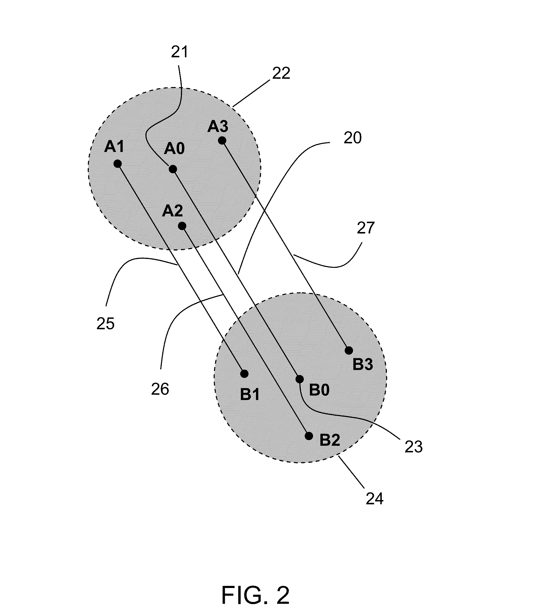
[0011]The invention may take advantages of two principles disclosed in the disclosure: relative positioning map-matching lane correlation and GPS-update-interval speed positioning. Relative positioning map-matching lane correlation provides a method to perform lane recognition by matching relative positions of base vehicle and nearby vehicle with road path in vicinity provided by digital road map to correlate positions of base vehicle and nearby vehicle with respective lanes of the road path. This method allows base vehicle to discern whether a nearby vehicle is moving on the same lane or different lane. When certain condition is satisfied, it also permits to determine specific lane location of base vehicle and sometimes specific lane location of nearby vehicle as well. The method takes advantages from several aspects to work properly. One aspect is that only lane locations of base vehicle and vehicle in proximity really matter for purpose of road safety enhancement, thus not necessary to determine lane location of a vehicle outside the mattered area. Another aspect is that GPS positioning error within a small vicinity is very consistent, thus relative positions of base vehicle and nearby vehicle having much higher accuracy than their absolute positions. The other aspect is that road path in a small vicinity mattered for the purpose is close to a straight path.
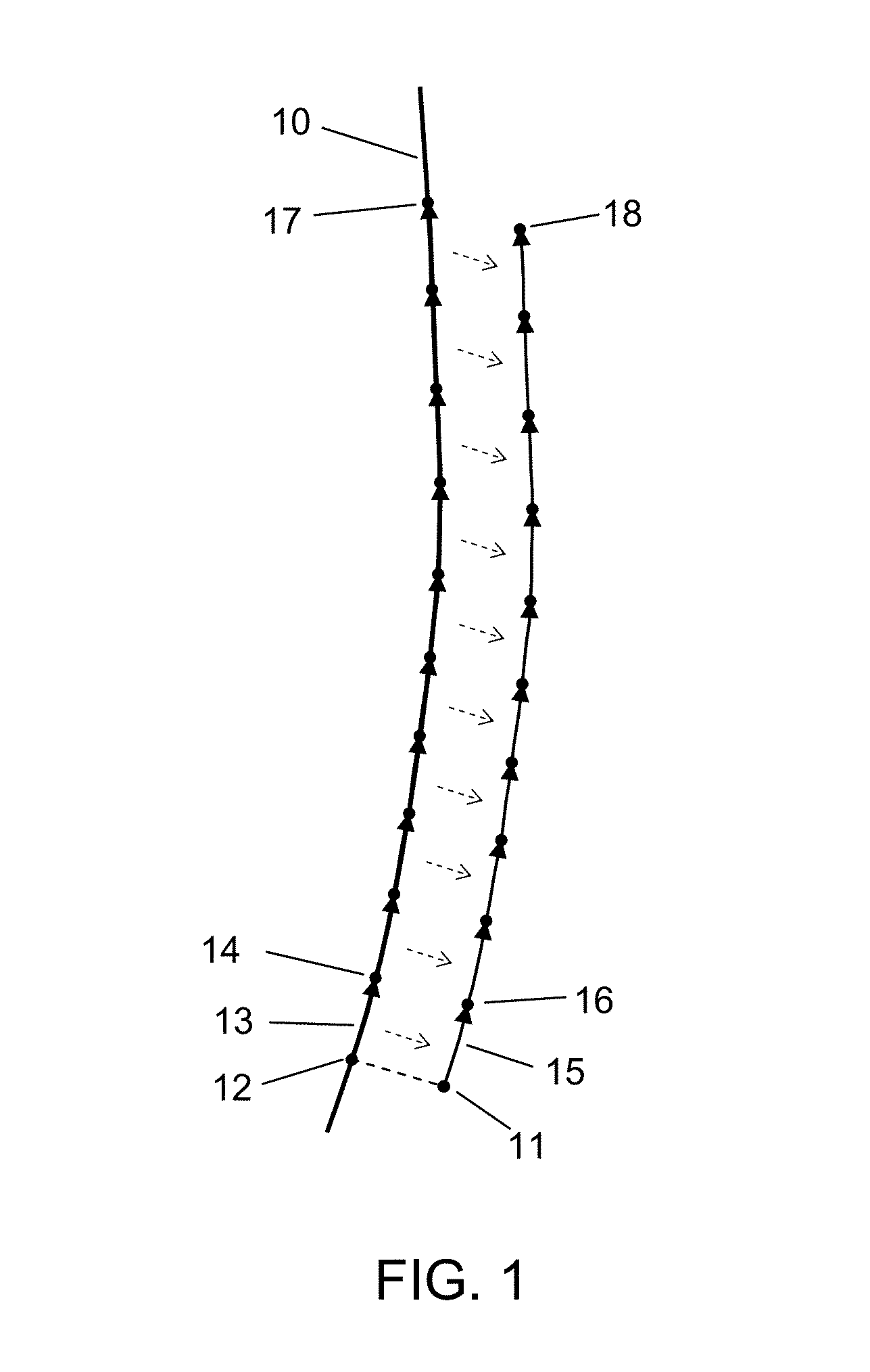
[0012]GPS-update-interval speed positioning provides a method to use speed obtained from speedometer of vehicle to calculate latest position in conjunction with road path that the vehicle is moving along during updating time interval of GPS positioning. Because speedometer responds fast to speed variation and is sufficiently accurate, the method can provide up-to-time positioning data starting after one GPS location is measured and ending when next GPS location is measured, then repeating that for next updating time interval of GPS receiver. Since the method only has to calculate vehicle positions during GPS updating time interval, which is typically several seconds, accumulation of positioning error in such short term is insignificant to positioning accuracy needed for purpose of road safety enhancement. The method gives a solution to reliably update vehicle location during update time interval of GPS receiver.
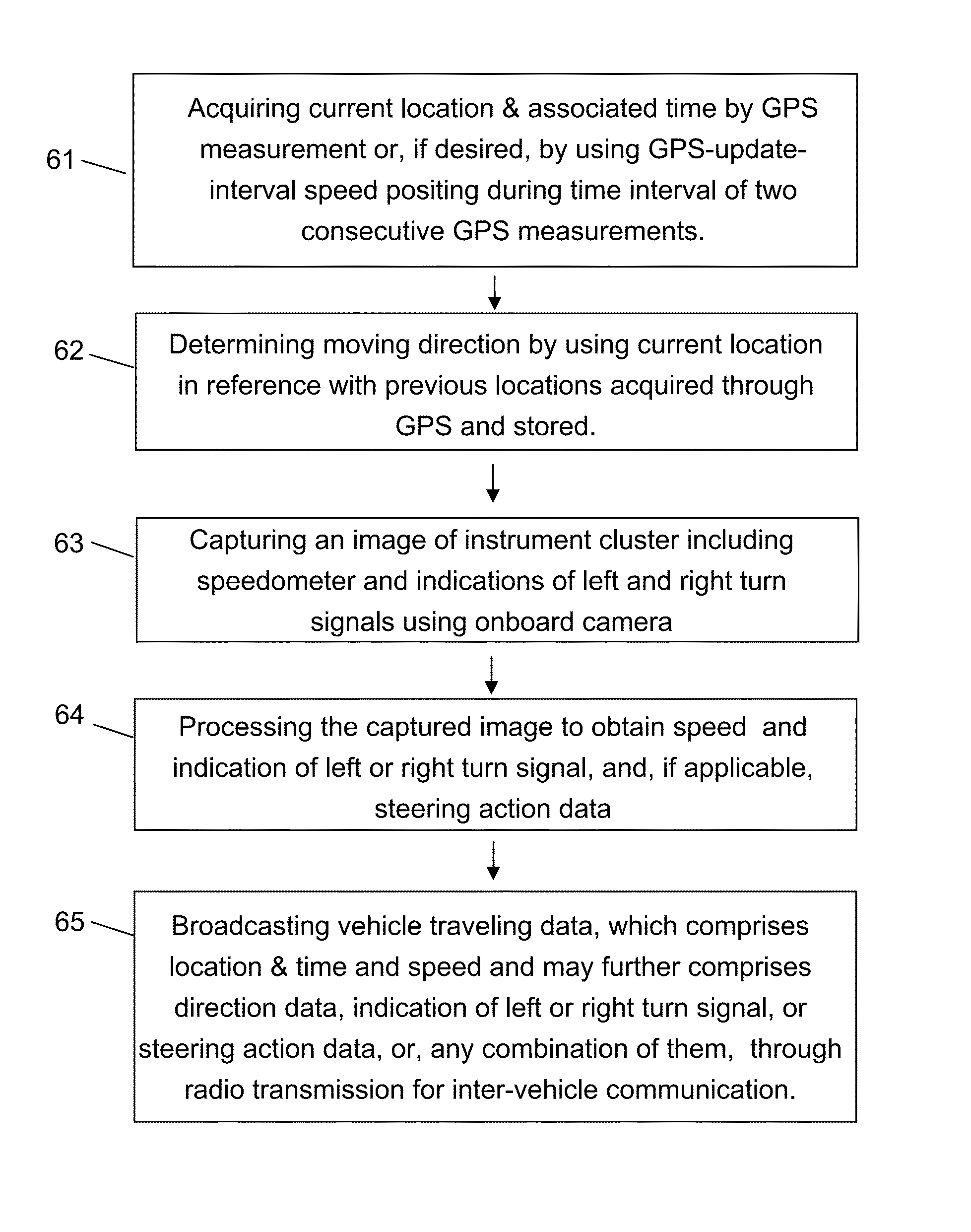
[0013]In accordance with the invention, the disclosure presents a method of vehicle traveling data broadcasting, in which a mobile communication device carried with a vehicle obtains vehicle moving data and broadcasts vehicle traveling data comprising the moving data through radio transmission for nearby vehicle to receive. The mobile communication device obtains vehicle location data from GPS measurement and speed of vehicle through image capturing and recognition of speedometer of the vehicle. Furthermore, the mobile communication device may use GPS-update-interval speed positioning to refresh position data more frequently than GPS update rate. The inter-vehicle sharing of vehicle moving data with accurate speed and high position refreshing rate forms a solid ground of information to achieve reliable and timely responsive road hazard warning for road safety enhancement. Driver's intended or going-on steering action, if available, may be included in the broadcasted messages in additional to the moving data. Driver's intended steering action such as left or right turn indication presented on instrument cluster may be obtained by the MCD using imaging capturing and recognition of instrument cluster. Driver's going-on steering action may be obtained by the MCD, which is placed in such way that it tilts in coupling with steeling wheel rotation, using image capturing of instrument cluster and tilted angle recognition of the captured image.
[0014]In accordance with the invention, the disclosure further presents a method of road hazard early warning, in which a mobile communication device (MCD) carried with a base vehicle receives moving data of nearby vehicle that is broadcasted through radio transmission and keeps tracking moving status of nearby vehicle, and, determine potential collision or other road hazard involving with nearby vehicle according to moving status of base vehicle. Image capturing and processing of speedometer of vehicle by a mobile communication device may be used to get speed of vehicle to facilitate the road hazard determination. Relative positioning map-matching lane correlation may be used to improve accuracy and reliability of road hazard early warning. Driver's currently going-on or intended steering action such as left / right steering or acceleration / deceleration, if available, may be taken account of determining potential road hazard in conjunction with moving data of vehicle. Driver's steering action may be obtained by a mobile communication device (MCD) coupled with movement of steering wheel to capture images of instrumental clusters of vehicle using onboard camera of the MCD and process captured images to detect the movement of steering wheel or speed indication of speedometer. Driver's intended steering action may be obtained by detecting left / right turn indication on instrumental cluster through image capturing and processing thereof. If a potential road hazard is determined, driver is given appropriate warning in audio form, visual form or combination thereof to take avoidance action. Regardless of whether a potential road hazard is found or not, the method may present location of nearby vehicle relative to base vehicle in either audio form, visual form or combination thereof in order for driver to get better situation awareness of nearby road usage. Audio form may be provided through either onboard speaker of the MCD or an external speaker coupled with the MCD. Visual form may be provided on either display screen of the MCD or an external display coupled with the MCD, such as vehicle mounted display, HUD (head up display), display of other device, and so on.
[0015]In accordance with the invention, the disclosure further presents a method of driving action warning, in which a mobile communication device (MCD) on board a base vehicle detects driver's driving action through image capturing and recognition of instrument cluster of base vehicle and evaluate potential road hazard or collision to be caused by the driving action by analyzing the driving action in conjunction with traveling status of base vehicle and nearby vehicles. Once driver's driving action is found dangerous, the MCD is to immediately alert driver to correct the driving action. The method is advantageous in avoiding driver initiated road hazard.
[0016]In accordance with the invention, the disclosure further presents a method of road navigation enhancement, in which a mobile communication device on board a base vehicle may perform relative positioning map-matching lane correlation by utilizing position data of nearby vehicle received through inter-vehicle communication to determine lane location of base vehicle and / or GPS-update-interval speed positioning to get more timely updated position data of base vehicle, and, then, use the lane location and / or the timely updated position data to enhance road navigation. With lane location available, road navigation can give driver more precise and more detailed steering instruction. With position data refreshed more frequently, road navigation is more responsive to give corrective road guidance when incompliance to road guidance occurs. The method may also use driver's steering action such as left / right steering or acceleration / deceleration, if available, to enhance road navigation. Driver's steering action may be obtained by a mobile communication device (MCD) coupled with movement of steering wheel to capture images of instrumental cluster of vehicle using onboard camera of the MCD and process captured images to detect the movement of steering wheel or speed indication of speedometer. Analyzing continuous steering actions over a time span after initialization can determine whether vehicle is making lane shift, road turn, or other change of movement. The method allows real time response of road navigation to driver's steering action. Furthermore, driver's driving action including acceleration / deceleration, intended left / right steering indicated by indication of left / right turn signal, and going-on steering action indicated by steering wheel rotation may be used to determine driving compliance to navigation instructions and notify driver to correct if noncompliance is found.