

Coordinate-free measurement-domain navigation and guidance using location-dependent radio signal measurements
a technology of radio signal measurement and coordinates, applied in the direction of direction finders, navigation instruments using radio waves, instruments, etc., can solve the problems of local disturbance of prior-art techniques for converting radio signal measurements into coordinates for navigation and guidan
- Summary
- Abstract
- Description
- Claims
- Application Information
AI Technical Summary
Benefits of technology
Problems solved by technology
Method used
Image

Examples
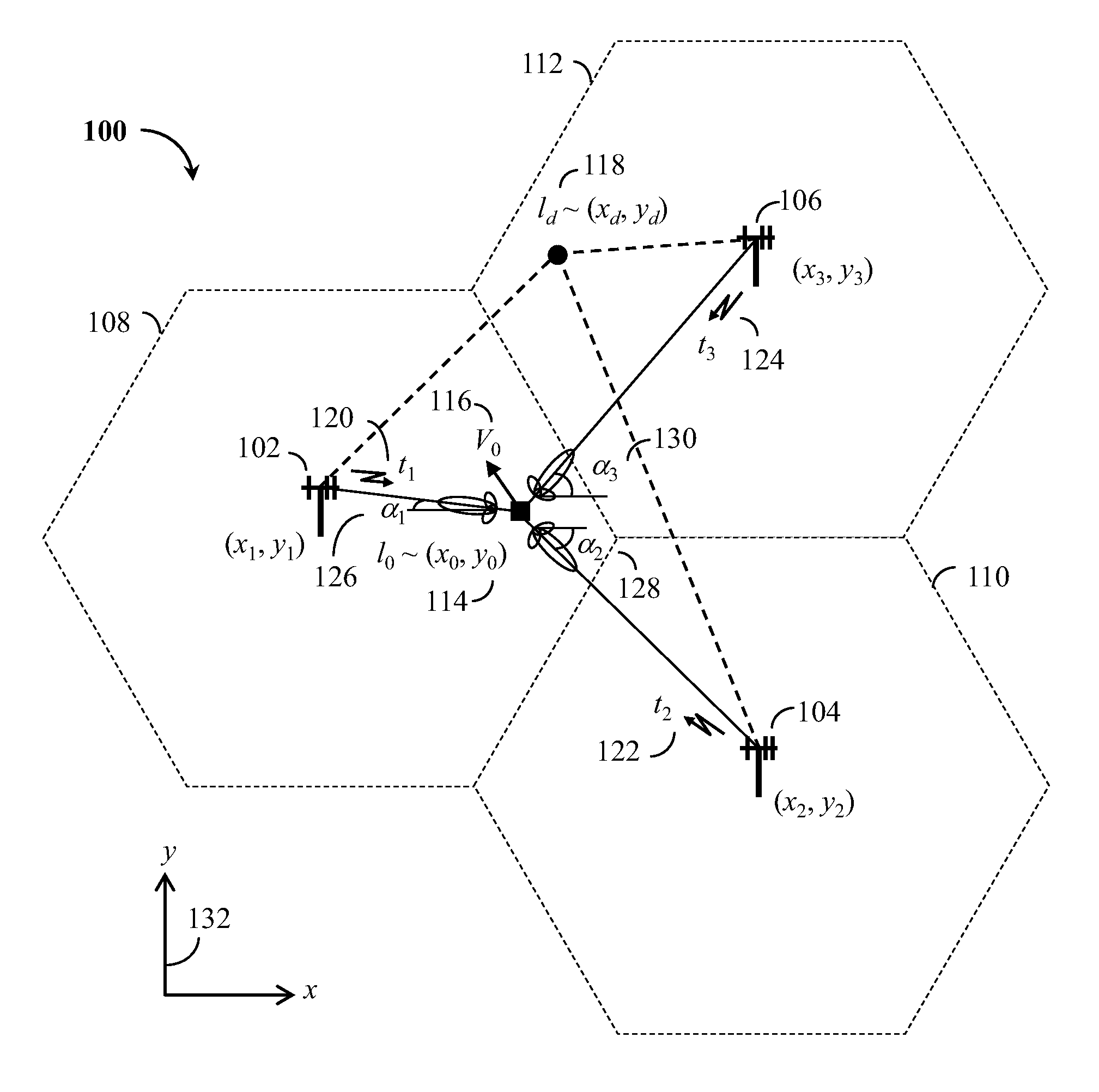
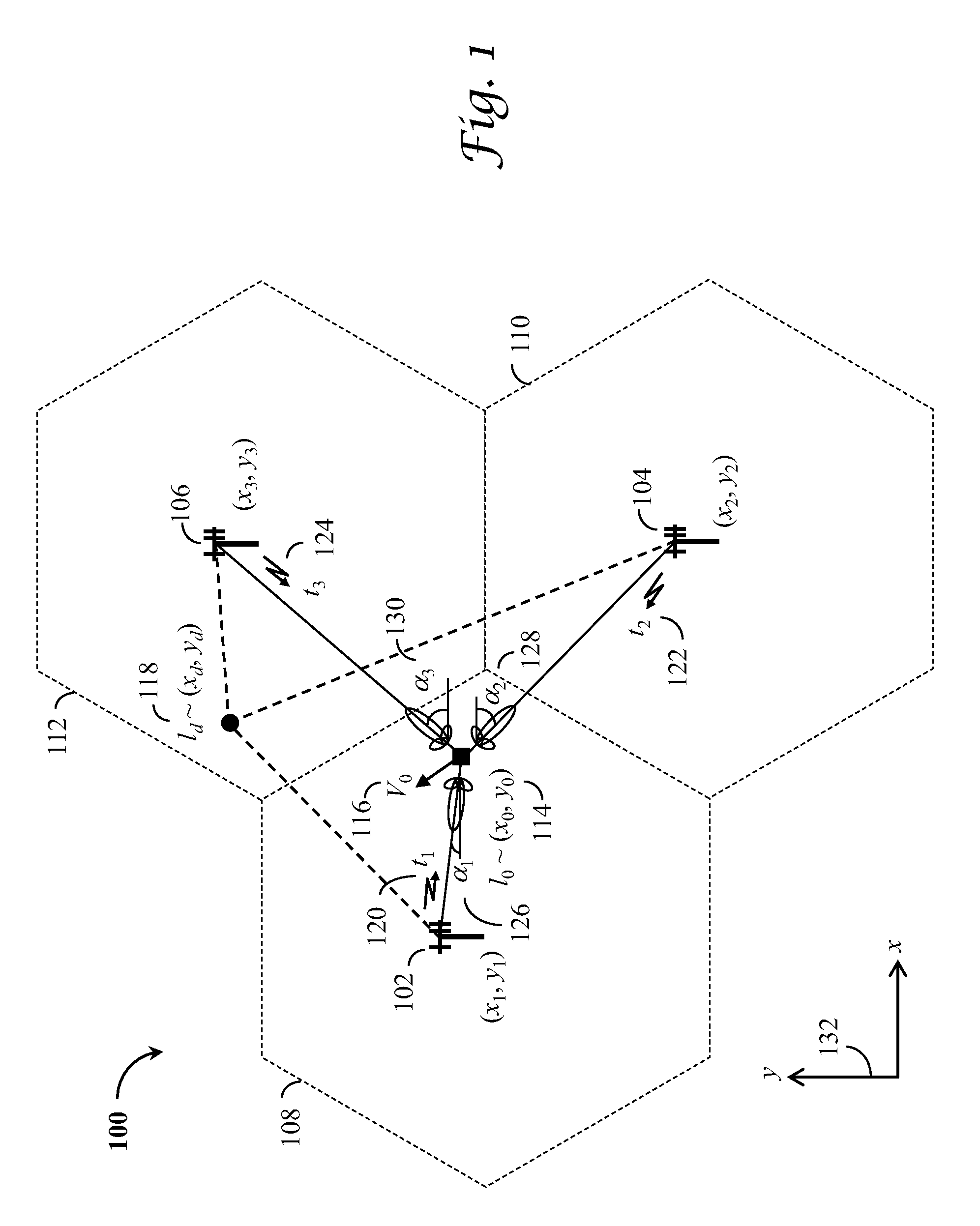
exemplary embodiment 100
[0039]Referring to FIG. 1, an exemplary embodiment 100 of the present invention is sketched wherein three neighboring base stations 102, 104, and 106 are present, each dominating a service cell 108, 110, and 112, respectively. For simplicity, only a two-dimensional (2D) coordinate system 132 is considered, which represents the underlying true but unknown geometry. The base station transceiver antennas are located at (xi,yi), i=1, 2, 3, which are unknown to a mobile user located at (x0,y0) 114 moving at a speed V0 116. An objective of the mobile user is to move from its current location 114 to a destination at (xd,yd) 118. However, in a preferred coordinate free embodiment of the present invention, both the current location 114 and the destination 118 are represented by their equivalent labels l0˜(x0,y0) and ld˜(xd,yd), respectively, which are location-dependent and measurable from radio signals.
[0040]Still referring to FIG. 1, consider continuously transmitting radio sources such as...
exemplary embodiment 700
[0064]Referring to FIG. 7, an exemplary embodiment 700 of the architecture of an analog front end 740, a baseband signal processor 742, and a data pre-processor 744 is illustrated in accordance with the present invention. The analog front end 740 consists of an antenna 702, a low-noise amplifier (LNA) and radio frequency (RF) front end 704, and an analog to digital converter (ADC) 706. The antenna 702 captures radio signals, which are processed in the RF front end 704, with stages of bandpass-filtering, amplification, and down-conversion, into a suitable intermediate frequency (IF) for sampling by the ADC 706. A frequency synthesizer 708 is used to provide the required frequency components to the RF front end 704 and ADC 706 as well as the baseband signal processor 742.
[0065]Still referring to FIG. 7, a plurality of tracking channels 710, 712, and 714 are implemented in the baseband signal processor 742, each assigned to a received signal. A tracking channel consists of an outer loo...
exemplary embodiment 800
[0068]Now referring to FIG. 8, an exemplary embodiment 800 of method steps for coarse navigation and guidance is illustrated in accordance with the present invention. Current sector angle estimates 802 are obtained either from block 738 of FIG. 7 via a path 806 or based on array antenna AOA estimates 804. The current sector angle estimates 802 are compared to the set of destination parameters 808, yielding errors to go 810. Furthermore, the current sector angle estimates 802 are compared to the previous sector angle estimates 812, producing the change in sector angles 814. The errors to go and the change in sector angles are processed to find best step and direction to move 818.
[0069]Still referring to FIG. 8, current differential time of flight estimates 820 are obtained either based on code phase 726 from 734 via 824 or based on carrier phase 720 from 734 via 822. The current differential time of flight estimates 820 are compared to the set of destination parameters 826, yielding ...
PUM
 Abstract
Description
Claims
Application Information