High integral navigation device combined by MIMU/GPS/micromagnetic compass/barometric altimeter

A combined navigation system and barometric altimeter technology, which is used in navigation, navigation, mapping and navigation through velocity/acceleration measurement, can solve problems such as the influence of horizontal attitude accuracy, heading angle error, poor accuracy, etc., to improve dynamic range and Responsiveness, improved fault tolerance and reliability, cost and quality reduction

Inactive Publication Date: 2007-07-18
BEIHANG UNIV
View PDF0 Cites 88 Cited by
  • Summary
  • Abstract
  • Description
  • Claims
  • Application Information

AI Technical Summary

Problems solved by technology

Although the carrier can obtain high-precision heading angle information when maneuvering, the accuracy of the horizontal attitude at this time is affected
And in the actual flight test, the carrier cannot always maneuver, so the heading angle error will still diverge after the maneuver stops
Some researchers also use the MIMU / GPS / magnetometer integrated navigation system to improve the accuracy of the carrier's heading angle. Because the strapdown magnetometer heading algorithm needs to use the horizontal attitude angle obtained by the MIMU strapdown algorithm, but the currently used The magnetometer is not integrated with the MIMU, which will cause installation errors and lead to low accuracy of the calculated heading angle
[0005] All in all, the current integrated navigation system has the disadvantages of large size, difficulty in integration, and poor accuracy, and it is difficult to meet the high-precision navigation requirements of tiny aircraft.

Method used


Image

  • High integral navigation device combined by MIMU/GPS/micromagnetic compass/barometric altimeter
  • High integral navigation device combined by MIMU/GPS/micromagnetic compass/barometric altimeter
  • High integral navigation device combined by MIMU/GPS/micromagnetic compass/barometric altimeter

Examples


Embodiment Construction

[0024] The present invention will be described in further detail below in conjunction with the accompanying drawings.

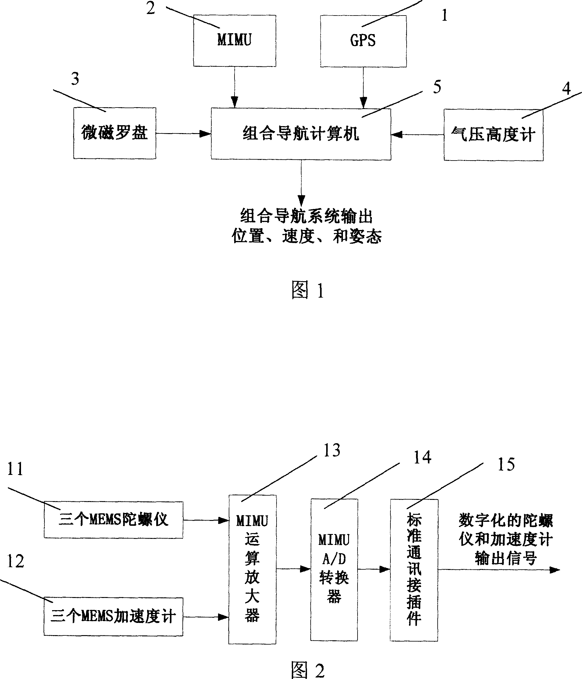
[0025] As shown in Fig. 1, the present invention is a highly integrated MIMU / GPS / micromagnetic compass / barometric altimeter integrated navigation system. It consists of MIMU subsystem 1, GPS subsystem 2, micro-magnetic compass subsystem 3, barometric altimeter subsystem 4 and integrated navigation computer 5 embedded with navigation algorithms. The integrated navigation computer 5 processes and fuses the data of MIMU subsystem 1, GPS subsystem 2, micromagnetic compass subsystem 3, and barometric altimeter subsystem 4, and then outputs position, speed and attitude information.

[0026]As shown in FIG. 2 , the MIMU subsystem 1 is composed of three MEMS gyroscopes 11 , three MEMS accelerometers 12 , MIMU operational amplifiers 13 , MIMU A / D converters 14 , and standard communication connectors 15 . MEMS gyroscope 11 and accelerometer 12 output analog signals of...


PUM


Abstract

The invention relates to high integrity MIMU / GPS / micro magnetic compass / pressure altitude gage integrated navigation system. It is made up MIMU subsystem, GPS subsystem, micro magnetic compass subsystem, pressure altitude gage subsystem, and integrated navigation computer used to process subsystem output data and inosculate information to output carrier position, speed, and attitude information. The four subsystems adopt hard ware integrative high grade integration technique. The navigation computer adopts three embedding type microprocessor and has the feature of redundancy multiplexing. The GPS, micro magnetic compass, pressure altitude gage use one microprocessor together to process their algorithm. Navigation algorithm is made up of strap down inertial navigation algorithm, multi velocity model combined filtering algorithm. The invention has the advantages of small volume, low cost, high reliability, fast response speed and high precision. Thus it can be used in micro-miniature flyer precise navigation.

Description

technical field [0001] The invention relates to a real-time integrated navigation system, especially a highly integrated MIMU / GPS / micromagnetic compass / barometric altimeter integrated navigation system, which has the advantages of small size, light weight, low power consumption, low cost, strong reliability, and responsiveness. A series of incomparable advantages of traditional integrated navigation systems, such as fast speed and convenient mass production, can provide all motion parameters of the carrier without divergence in accuracy, and is suitable for the field of micro and small systems. Background technique [0002] Micro-mechanical inertial devices (micro-silicon gyroscopes, micro-silicon accelerometers) based on micro-electromechanical systems (MEMS) technology are becoming more and more mature, making MEMS-based micro inertial measurement units (Micro Inertial Measurement Unit, MIMU) in the civilian field It has broad application prospects, especially compared wit...

Claims


Application Information

Patent Timeline
Patent Type & Authority Applications(China)
IPC IPC(8): G01C21/00G01C21/26G01C21/28G01C21/20G01C21/16G01C21/18G01C21/36G01S1/02G01S5/02
Inventor 房建成曹娟娟盛蔚张霄孙宏伟孙科
Owner BEIHANG UNIV
Why Eureka
Try Eureka