Method of realizing combined navigation system structure for aviation

An integrated navigation system and architecture technology, applied in the field of aviation integrated navigation system architecture, can solve problems such as heavy computing burden, poor system survivability, and difficult data interconnection, and achieve the effect of improving accuracy, reliability and availability

Inactive Publication Date: 2007-10-03
BEIHANG UNIV
View PDF0 Cites 35 Cited by
  • Summary
  • Abstract
  • Description
  • Claims
  • Application Information

AI Technical Summary

Problems solved by technology

The existing navigation integrated navigation architecture is mainly centralized and distributed. The centralized structure is to send all the measurement data of the navigation system to a central processor for processing and fusion, data alignment, data interconnection and filtering. The structure requires a data transmission bus with a wide frequency band to transmit high-speed raw data. Data interconnection is difficult, and the system must have a large capacity. The calculation burden is heavy, and a central processing unit with strong processing power is required. Therefore, the system The survivability is poor; the existing distributed structure mainly adopts the federated filtering structure, as shown in Figure 1, which is characterized by: the measurement information of n subsystems is sent to the local filter for local filtering before being transmitted to t

Method used


Image

  • Method of realizing combined navigation system structure for aviation
  • Method of realizing combined navigation system structure for aviation
  • Method of realizing combined navigation system structure for aviation

Examples


Embodiment Construction

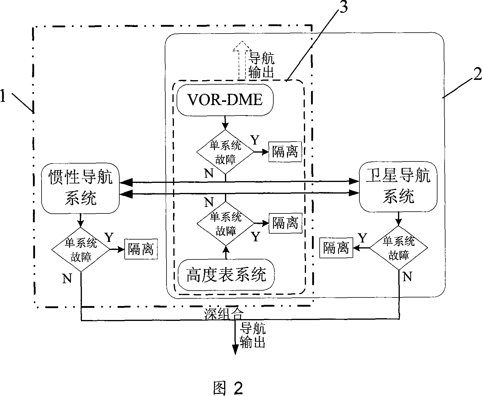
[0020] The present invention will be described in further detail below in conjunction with accompanying drawing

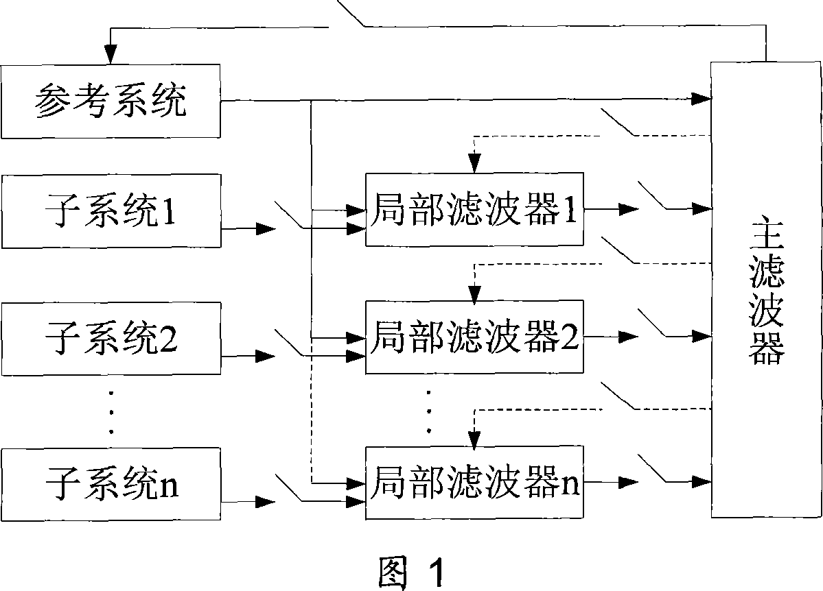
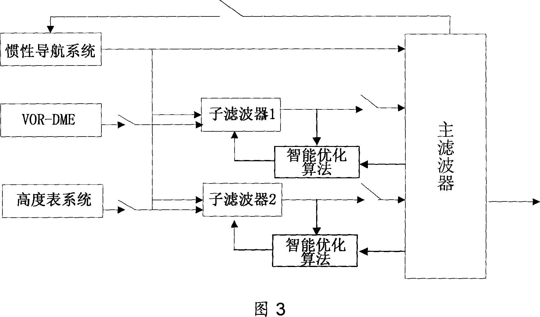
[0021] As shown in Figure 2, the present invention is made up of four systems of inertial navigation system, satellite navigation system, VOR-DME, altimeter system. VOR-DME and the altimeter system provide the distance between the aircraft and the destination, the orientation relative to the destination and the altitude information of the aircraft, thereby determining the position information of the aircraft, and transmitting the information of the VOR-DME and altimeter system to the inertial navigation system And the satellite navigation system to form two federal structure integrated navigation systems, and then the inertial navigation system and the satellite navigation system are deeply combined to output high-precision navigation information. The multi-level layered information fusion method is used to realize the architecture of aviation integrated navigation...


PUM


Abstract

The combined navigation system for aviation consists of inertia navigation system, satellite navigation system, VOR-DME and altimeter. After fault diagnosis to judge the normality and the availability of the separate navigation systems, the normal navigation systems are combined to form one multistage multi-layer structure. By means of information fusion, high precision navigation information is obtained from the combined navigation system. In case of some navigation system with fault, the failed navigation system is isolated and the system is reconstructed for further navigation. The present invention can raise the reliability and availability of the combined navigation system for aviation.

Description

technical field [0001] The invention relates to an integrated navigation system architecture, in particular to an aviation integrated navigation system architecture suitable for a new generation of national air traffic management system. Background technique [0002] High-performance aviation navigation is the key technology of the new generation of national air traffic control system and an inevitable requirement for the safety of aircraft navigation. The new generation of national air traffic control system puts forward higher requirements for the accuracy, integrity, continuity and availability of the aviation navigation system . [0003] At present, civil aviation navigation in the world has developed from a single navigation method to a high-precision, high-reliability, comprehensive, and intelligent aviation integrated navigation system; the information processing method has also changed from a single data source to multiple navigation sensors and multiple data sources...

Claims


Application Information

Patent Timeline
IPC IPC(8): G01C21/00G01C21/16G01S5/00
Inventor 房建成徐帆盛蔚崔培玲刘百奇全伟
Owner BEIHANG UNIV
Why Eureka
Try Eureka