GPS navigation method and system

A technology of GPS navigation and navigator, applied in the field of GPS navigation, can solve problems such as lack of evaluation methods and opportunities, high capital investment, and unused data, and achieve the effects of reducing one-time investment, protecting interests, and preventing malicious cracking

Inactive Publication Date: 2011-08-31
SHENZHEN SEG SCI NAVIGATIONS CO LTD
View PDF0 Cites 1 Cited by
  • Summary
  • Abstract
  • Description
  • Claims
  • Application Information

AI Technical Summary

Problems solved by technology

[0006] Furthermore, in the current GPS navigation products, users often need to purchase navigation software at one time, which requires high capital investment, and most of the data is not used, especially in the initial stage of evaluating navigation electronic maps, users do not have suitable evaluation means and Chance
Thus setting a threshold for the popularization and use of navigation software

Method used


Image

  • GPS navigation method and system
  • GPS navigation method and system
  • GPS navigation method and system

Examples


Embodiment Construction

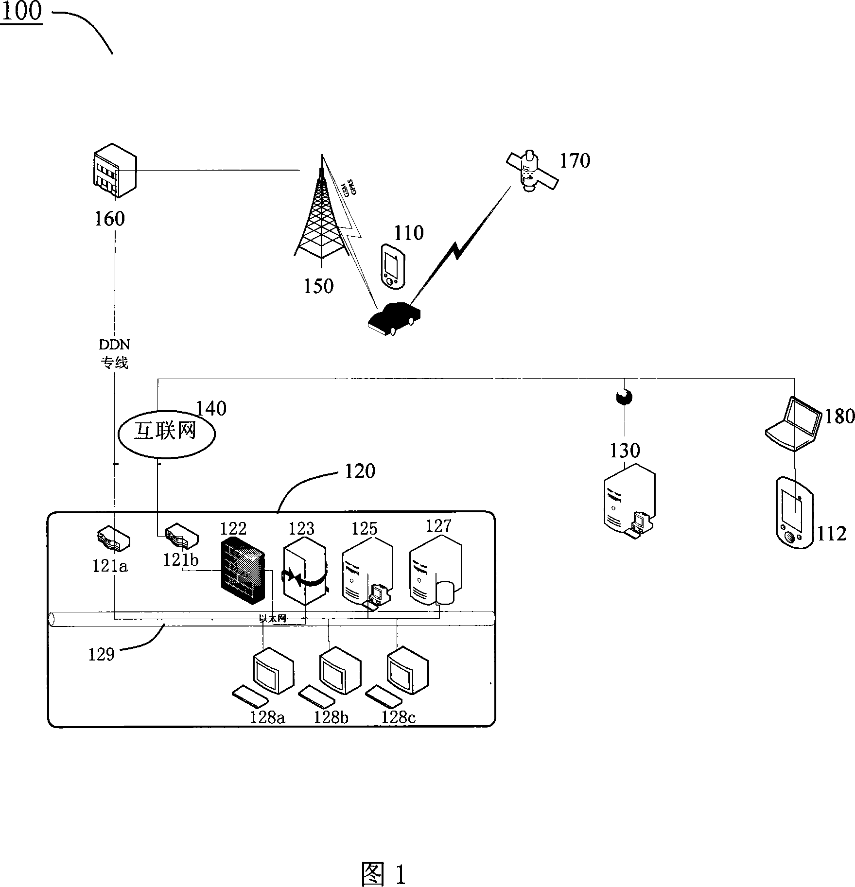
[0040] The technical solution of the present invention is to provide a GPS navigation method and system capable of charging according to the user's use times and / or usage amount, and issuing map data increments on demand. Since the standard time and position can be obtained by GPS positioning, it provides protection for pay-per-view and prevents authorization from being maliciously cracked.

[0041] Such as figure 1 As shown, in one embodiment, the GPS navigation system 100 of the present invention includes navigators 110 and 112, a call center 120, an Internet map server 130, the Internet 140, a wireless communication network base station 150, a mobile operator 160, GPS satellites 170, Notebook computer 180 and urban dynamic traffic information provider (not shown in the figure).

[0042] Call center 120 includes routers 121 a and 121 b , security wall 122 , gateway 123 , map server 125 , database server 127 , call agents 128 a , 128 b , 128 c and Ethernet 129 . The call ce...


PUM


Abstract

The invention relates to a GPS navigation method and a system and comprises that a navigator sends a navigation requirement to a calling center, wherein, the navigation requirement comprises the information about the present position of the navigator, the information about the position of the destination and the ID information of the navigator; the calling center formulates a routes plan based onthe navigation requirement and a dynamic traffic information; the calling center delivers the routes plan and an authorization information for activating a map file in the navigator to the navigator;the navigator receives the routes plan and the authorization information and activates the map file to display the planed routes; in the running process of the vehicle, the calling center formulates a novel routes plan according to the latest position information and the dynamic traffic information sent out by the navigator and delivers the novel routes plan to the navigator. In addition, the navigator sends out the edition information of the map file corresponding to the road sections around the present position stored in the navigator while sending out the present position information; the calling center compares the received edition information with the edition of the map used by the calling center and then determines the data increment of the map and delivers the data increment to thenavigator.

Description

technical field [0001] The invention relates to GPS navigation technology, more specifically, to a pay-per-view dynamic navigation method and system. Background technique [0002] The navigation electronic map has two characteristics: it is an electronic data product and it has a navigation function. The biggest difference between ordinary electronic map and navigation electronic map is that the former does not have navigation function. In order to realize navigation, only map data is not enough. There must be a map engine for path planning, selection and other functions. Map data and map engine (software) are inseparable. [0003] GPS navigator is a car driving assistance device that can help users accurately locate the current location, calculate the itinerary according to the established destination, and guide the user to the destination through map display and voice prompts. It includes two important components: First, the Global Positioning System (Global Positioning...

Claims


Application Information

Patent Timeline
Patent Type & Authority Patents(China)
IPC IPC(8): H04L29/08G01C21/34G01C21/26G01D4/00
Inventor 金铃淇
Owner SHENZHEN SEG SCI NAVIGATIONS CO LTD
Why Eureka
Try Eureka