Remote sensing and quantizing reconnaissance method of snowslide

A remote sensing, high-resolution technology, used in the site selection and comparison of engineering plans, automatic extraction and quantitative analysis of avalanche disaster information, and optimization in the field, it can solve problems such as dependence and inability to meet engineering construction, and achieve high accuracy. , to achieve automatic extraction, comprehensive survey effect

Active Publication Date: 2008-07-16
CCCC SECOND HIGHWAY CONSULTANTS CO LTD
View PDF0 Cites 24 Cited by
  • Summary
  • Abstract
  • Description
  • Claims
  • Application Information

AI Technical Summary

Problems solved by technology

However, this method relies too much on the interpreter's knowledge level and experience accumulation. Most of the remote sensing data sources used are medium and low-resolution satellite images of a single period, and can only perform simple remote sensing identification and qualitativ

Method used


Image

  • Remote sensing and quantizing reconnaissance method of snowslide
  • Remote sensing and quantizing reconnaissance method of snowslide
  • Remote sensing and quantizing reconnaissance method of snowslide

Examples


Embodiment Construction

[0027] Below in conjunction with accompanying drawing, the present invention is described in further detail:

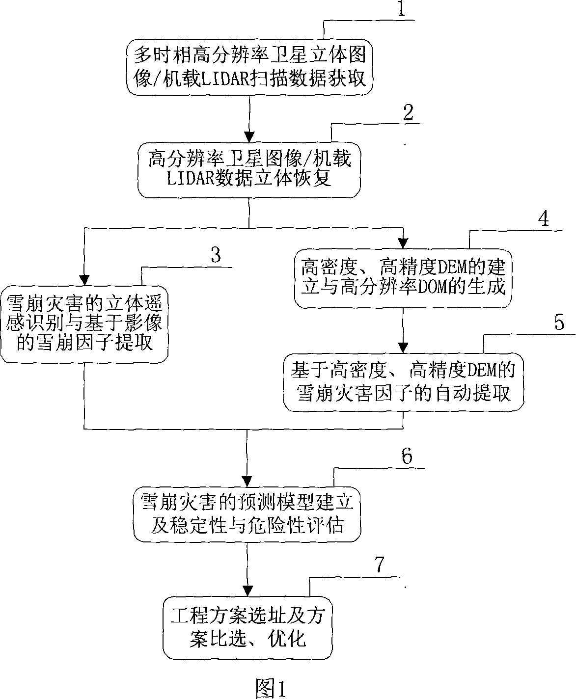
[0028] A remote sensing quantitative survey method for avalanche, as shown in Figure 1, it includes the following steps:

[0029] The first step, multi-temporal high-resolution satellite stereo image / airborne LIDAR scanning data acquisition1

[0030] The survey area should select at least two different periods (two periods with less snow cover and more periods), and the resolution of satellite imaging is less than 1m high-resolution satellite stereoscopic images, such as IKONOS satellite images with a resolution of 1m, or The 0.47m WorldView satellite image can also be the image obtained by airborne LIDAR scanning with CCD camera in different periods.

[0031] High resolution satellite stereo imagery should have rational function sensor model (RPC) parameters. Airborne LIDAR data should have attitude positioning parameters such as GPS and IMU (inertial measurement u...


PUM


Abstract

The invention discloses a remote-sensing and quantized investigation method of avalanches and consists of the following steps: A. the three-dimensional satellite images with a plurality of phases and high resolution and the scanning data of a machine-carrying LIDAR are acquired; B. the satellite images with high resolution and the data of the machine-carrying LIDAR are stored into the three-dimensional space; C. the three-dimensional and remote-sensing identification of the avalanche disaster is implemented and an avalanche factor based on the images is extracted; D. a DEM with high density and high precision is constructed and a DOM with high resolution is generated; E. an avalanche disaster factor based on the DEM with high density and high precision is automatically extracted; F. a forecast model of the avalanche disaster is constructed and the stability and the fatalness of the avalanche disaster are evaluated; G. the site selection is implemented, and engineering schemes are voted and optimized. The invention achieves the automatically quantized analysis of avalanche investigation, has higher precision of identifying the avalanche disaster, can find out the law and the development trend of the avalanche disaster, implements the stability and fatalness evaluation of the avalanche disaster, avoids the influence of the avalanche disaster to engineering, achieves the action of reducing and preventing disasters, and markedly generates economic, social and environmental benefits.

Description

technical field [0001] The present invention relates to the technical field of automatic acquisition and quantitative analysis of spatial information of natural disasters and mountain disasters, in particular to the automatic avalanche disaster information using geospatial information such as high-resolution remote sensing satellite stereo images and airborne laser radar (LIDAR) scanning data. Extraction and quantitative analysis are applied to site selection of engineering schemes, scheme comparison, and optimization methods. Background technique [0002] Avalanches are a natural phenomenon in which a large amount of snow suddenly slides down and collapses rapidly along grooves or slopes, and is a serious natural disaster in alpine snow-covered areas. Avalanche disasters have the characteristics of sudden occurrence, fast speed and great destructive power, which often bring serious impact and loss to human society. In order to reduce the damage of avalanche disasters to th...

Claims


Application Information

Patent Timeline
IPC IPC(8): G01V1/00G01V1/22
Inventor 陈楚江余绍淮王丽园张霄
Owner CCCC SECOND HIGHWAY CONSULTANTS CO LTD
Why Eureka
Try Eureka