Error correcting method of navigation system

An error correction method and technology of a navigation system, applied in directions such as road network navigators, can solve problems such as low value of induced information, traffic accidents, and the system cannot recalculate paths, so as to reduce the possibility of traffic accidents and improve accuracy. Effect

Inactive Publication Date: 2009-11-11
SHENZHEN CARELAND TECH
View PDF0 Cites 17 Cited by
  • Summary
  • Abstract
  • Description
  • Claims
  • Application Information

AI Technical Summary

Problems solved by technology

[0006] To sum up, when the navigation system locates the navigation object on the wrong road, if there is no appropriate mechanism to correct the error, the system will not be able to recalculate the route, the value of the induced information is extremely low, and it is easy to cause traffic accidents

Method used


Image

  • Error correcting method of navigation system
  • Error correcting method of navigation system

Examples


Embodiment Construction

[0027] In order to make the object, technical solution and advantages of the present invention clearer, the present invention will be further described in detail below in conjunction with the accompanying drawings and embodiments. It should be understood that the specific embodiments described here are only used to explain the present invention, not to limit the present invention.
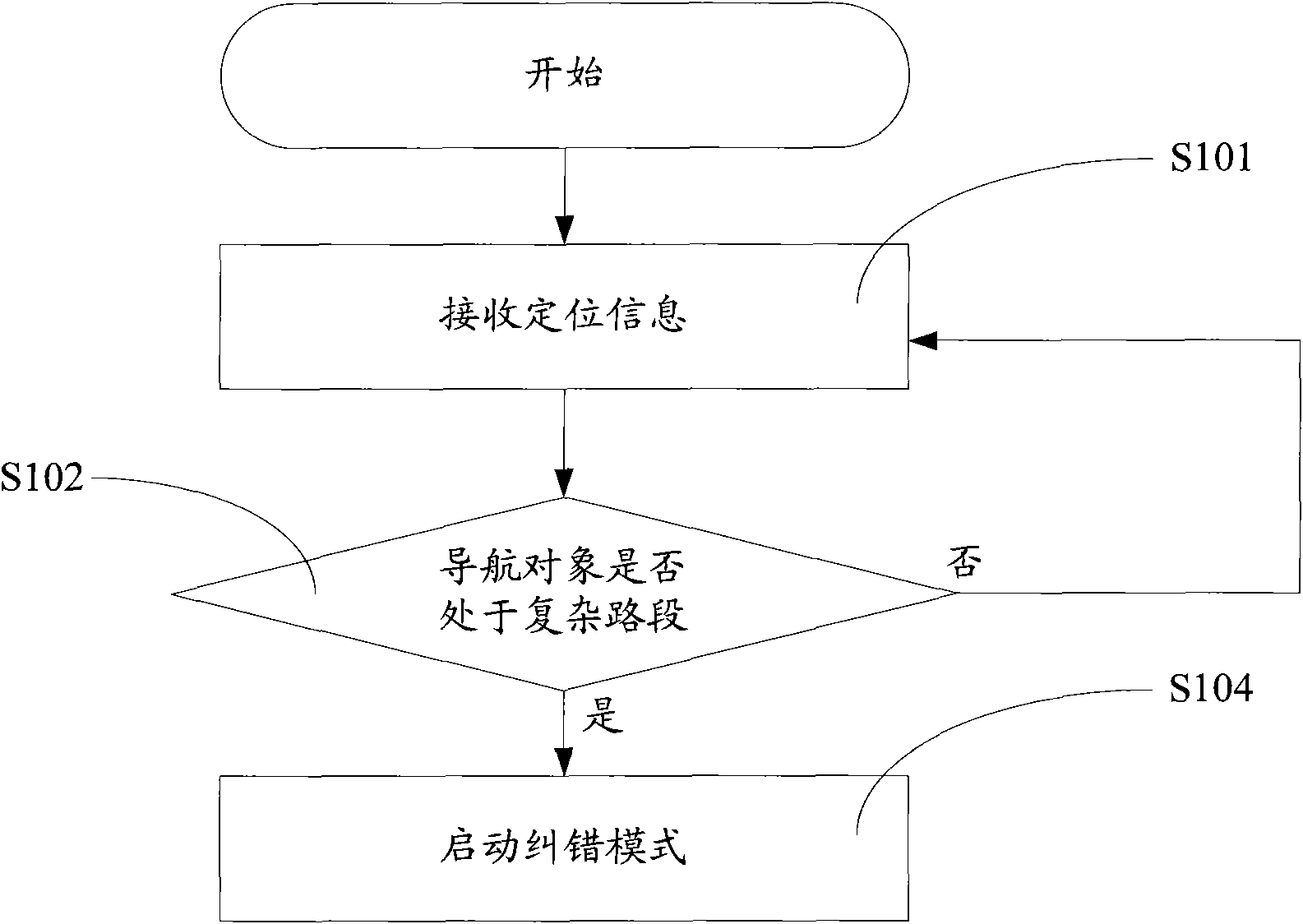
[0028] The idea of ​​the present invention is that when the navigation system judges that the navigation object is in a complex road section, it starts the error correction mode. In this mode, the tolerance threshold of the navigation system for position errors is reduced. After it is determined that the navigation object deviates from the original navigation path, selectable roads around the original path are listed for the user to select a correct location to generate a correct navigation path.

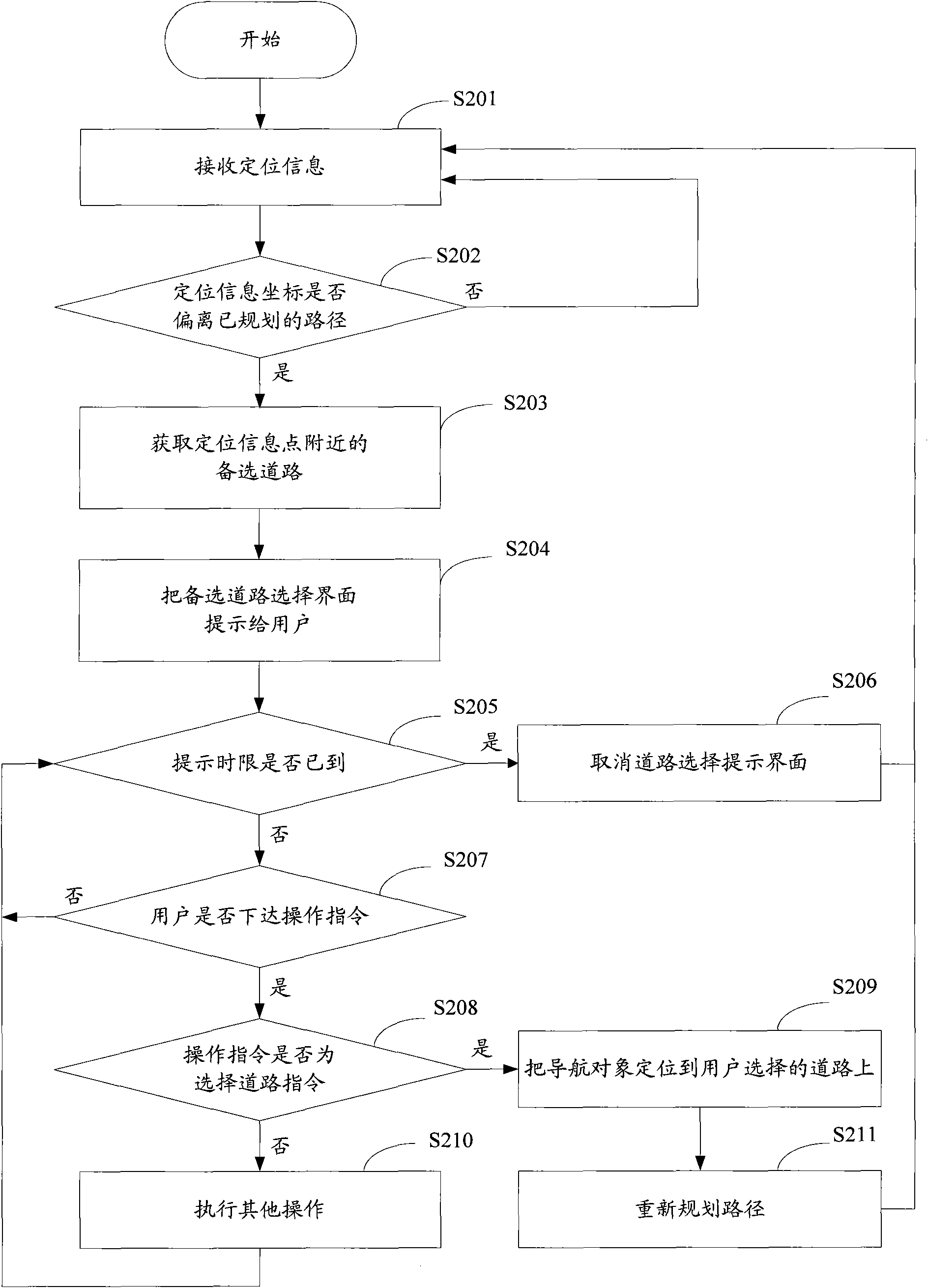
[0029] see figure 1 , the navigation system error correction method of the present invention first ...


PUM


Abstract

The invention relates to an error correcting method of a navigation system. The method receives GPS positioning information under a navigation error-correcting mode by starting the mode, judges whether a navigation object deviates from a planned path, if so, acquiring a standby channel in a first distance of the navigation object and displaying the standby channel provided for a user for selection. After adopting the technical proposal, the navigation system also can provide the chance of correcting the current positioning channel when the distance between the channels is shorter; therefore, compared with the existing navigation system of which the current positioning path can not correct errors, the invention reduces the possibility of traffic accident occurrence and improves the navigation information accuracy of the navigation system.

Description

technical field [0001] The invention belongs to the technical field of navigation, and in particular relates to a navigation method capable of correcting a navigation path under specific circumstances. Background technique [0002] At present, the global positioning system (Global Positioning System, GPS) for vehicles is one of the important application directions of GPS navigation. The GPS antenna of the car GPS navigation system receives the data information transmitted by at least 3 of the 24 GPS satellites around the earth, combined with the electronic map stored in the car navigation terminal, the position coordinates determined by the GPS satellite signal and this match to determine the exact position of the navigation object in the electronic map. The user driving the vehicle can let the computer select the driving path while driving, and use this as the direction guide, so as to reach the destination correctly and quickly. [0003] In the existing Global Positionin...

Claims


Application Information

Patent Timeline
Patent Type & Authority Applications(China)
IPC IPC(8): G01C21/26G01C21/34
Inventor 张文星
Owner SHENZHEN CARELAND TECH
Why Eureka
Try Eureka