Global positioning system error correction, vehicle tracking and object location

A technology of global positioning system and differential global positioning, which is applied in the directions of satellite radio beacon positioning system, positioning, radio wave measurement system, etc., can solve the problem that it is difficult to establish a precise picture of vehicle movement and the mode of driving and driver technology, and achieve improvement The effect of precision

Inactive Publication Date: 2010-05-19
EM8 TECH
View PDF0 Cites 14 Cited by
  • Summary
  • Abstract
  • Description
  • Claims
  • Application Information

AI Technical Summary

Problems solved by technology

Due to the low frequency at which the information is transmitted, it is difficult to build an accurate picture of vehicle movement or to determine patterns of driving and driver technique

Method used


Image

  • Global positioning system error correction, vehicle tracking and object location
  • Global positioning system error correction, vehicle tracking and object location
  • Global positioning system error correction, vehicle tracking and object location

Examples


Embodiment Construction

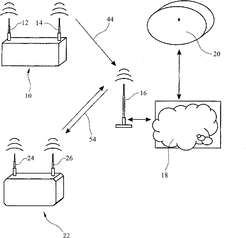
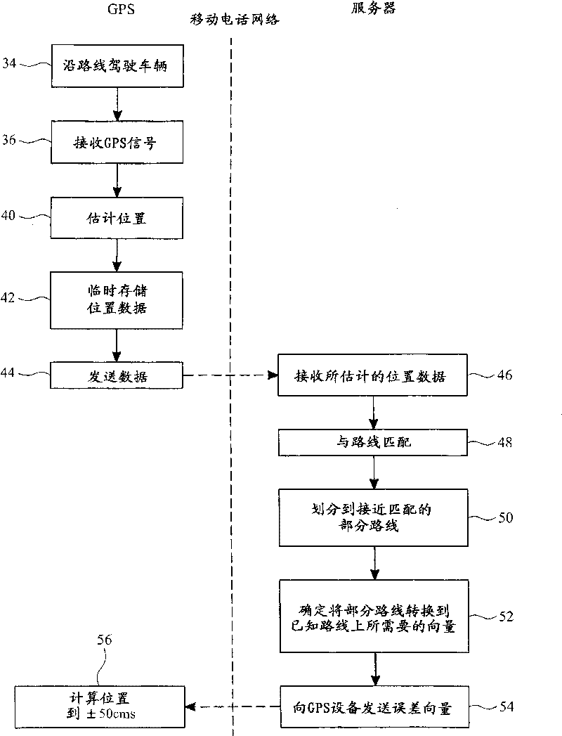
[0077] refer to figure 1 , the device used in the method of the present invention can utilize the following known devices. The mobile sensing unit 10 includes a GPS receiver 12 that receives GPS signals to estimate the location of the mobile sensing unit 10 . Unit 10 also includes a GPRS transmitter for transmitting data to a fixed GPRS transmitter / receiver 16 . Although in figure 1 In the example shown only a sending function is required for carrying out the method of the invention, but the GPRS transmitter 14 of the mobile sensing unit 10 can generally also be used as a receiver. Data received by the fixed GPRS transmitter / receiver 16 is sent via the Internet 18 to a processor / server 20 for calculating error correction factors.

[0078] Fixed GPRS transmitter 16 transmits the correction factor data to differential GPS 22 upon receipt of instructions from processor / server 20 via Internet 18 . The differential GPS 22 has a GPS receiver 24 (equivalent to the GPS receiver 12...


PUM


Abstract

A method and computer program for determining an error factor for a differential global positioning system is disclosed as well as a method of tracking a vehicle. In determining the error factor, estimated positional data is transmitted from a GPS via GPRS to a server. Since the GPS signals are being transmitted from a vehicle travelling along a known route, i.e. a road or rail track, the data can be matched to the route and a correction factor calculated. The error factor is then transmitted to differential GPS devices. For vehicle tracking a global positioning system sends, via GPRS, data a regular intervals relating only to its position.

Description

technical field [0001] The present invention relates to a method of correcting for errors in position determination by a GPS receiver and a method of tracking a vehicle using a GPS receiver, and in particular, but not exclusively, to the use of mobile telephone networks to receive and disseminate such data method. The invention also relates to a method and a device for locating objects. Background technique [0002] The use of Global Positioning System (GPS) devices to determine the location of a device is well known. GPS uses signals sent from satellites to triangulate and determine the location where the signals are received. This is done by determining the distance the signal traveled from the satellite to the GPS receiver, which is determined by multiplying the time it takes the signal to travel by the speed of light. But the speed of light is only constant in a vacuum, so as the GPS signal travels through the ionosphere and troposphere, it is bounced off ice and char...

Claims


Application Information

Patent Timeline
Patent Type & Authority Applications(China)
IPC IPC(8): G01C21/30
CPCG01C21/30G01S5/0072G01S19/41G01S5/009G01S5/0027G01C21/20G01C21/26G01C21/28G01C21/34
Inventor 菲利普·坦恩
Owner EM8 TECH
Why Eureka
Try Eureka