Multi-sensor combined navigation system for aviation

An integrated navigation system and multi-sensor technology, which is applied in the field of multi-sensor integrated navigation systems for aviation, can solve the problems of increased cost and system instability sources, difficulty in meeting high-speed, real-time navigation, and low data update frequency, and achieves reasonable installation, The effect of improving positioning and navigation accuracy and improving robustness

Inactive Publication Date: 2010-10-20
TIANJIN UNIV OF TECH & EDUCATION TEACHER DEV CENT OF CHINA VOCATIONAL TRAINING & GUIDANCE
View PDF0 Cites 37 Cited by
  • Summary
  • Abstract
  • Description
  • Claims
  • Application Information

AI Technical Summary

Problems solved by technology

However, the disadvantage of GPS is that its autonomy is poor, it is easy to be interfered, and the frequency of data update is low. When used alone, it is difficult to meet the requirements of high-speed and real-time navigation.
Although the accuracy has

Method used


Image

  • Multi-sensor combined navigation system for aviation
  • Multi-sensor combined navigation system for aviation
  • Multi-sensor combined navigation system for aviation

Examples


Embodiment Construction

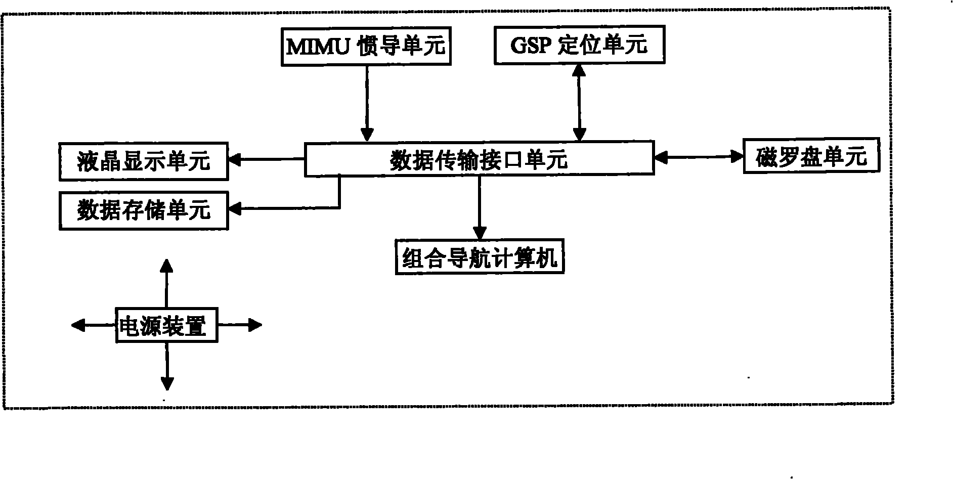
[0033] Such as figure 1 Shown: a multi-sensor integrated navigation system for aviation, which consists of a micro-inertial measurement unit MSINS, a GPS unit, a magnetic compass unit, a liquid crystal display unit, an integrated navigation computer embedded with navigation algorithm software, a data transmission interface unit, a data storage unit and a power supply Device composition; the integrated navigation computer receives the output data of the micro-inertial measurement unit MSINS, GPS unit, and magnetic compass unit through the data transmission interface unit, and outputs the position, speed and attitude information of the carrier after processing and information fusion; data transmission interface The output end of the unit is respectively connected with the liquid crystal display unit and the data storage unit.

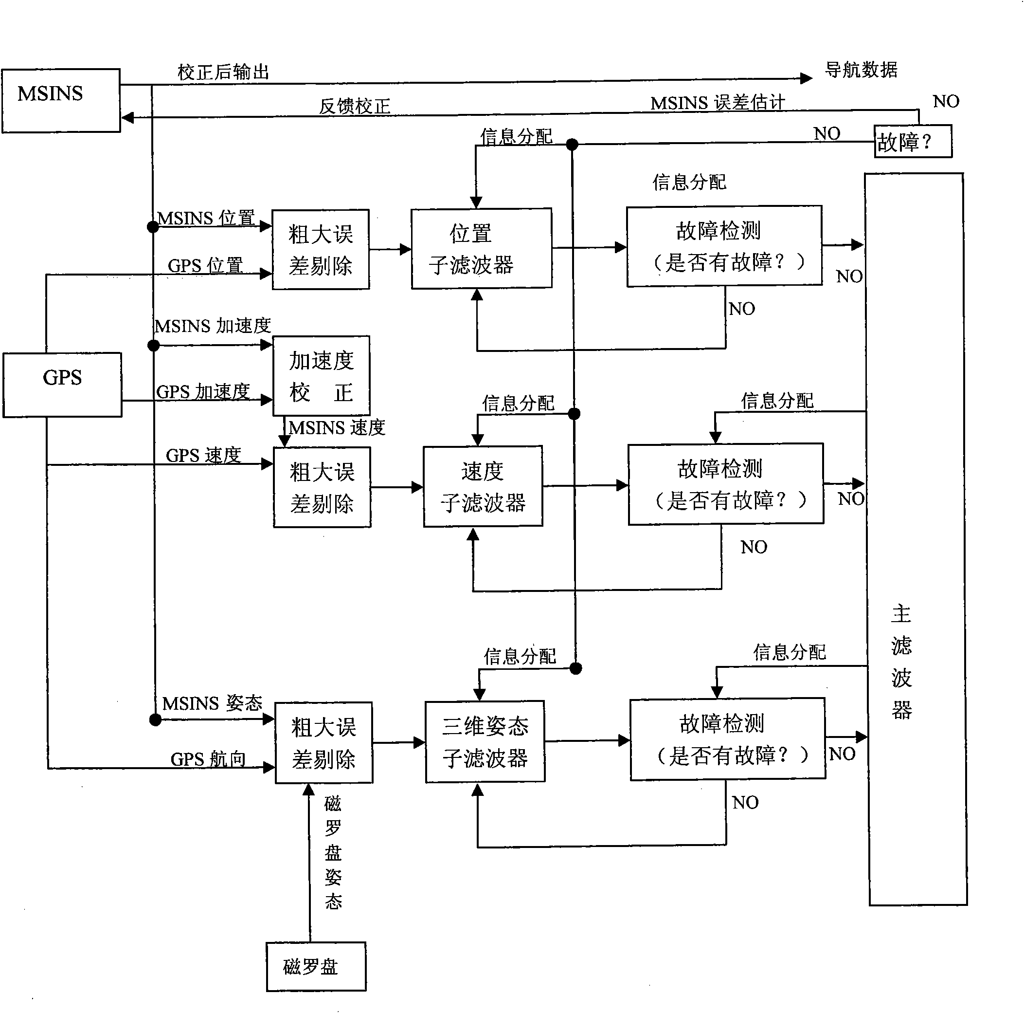
[0034] Such as figure 2As shown: the navigation algorithm embedded in the integrated navigation computer adopts the federated Kalman filter algorithm, ...


PUM


Abstract

The invention relates to a multi-sensor combined navigation system for aviation, and the system comprises an MSINS unit, a GPS unit, a magnetic compass unit, a liquid crystal display unit, a data transmission interface unit, a combined navigation computer, a data storage unit and a power supply device. The MSINS unit is used for acquiring signals of an accelerometer and a gyroscope, carrying out filtration and amplification and sending the signals to a DSP for carrying out algorithm processing; a GPS module is used for outputting longitude, latitude, altitude and velocity values of X, Y and Z axes based on a geocentric coordinate system measured by the GPS; the magnetic compass unit is used for outputting three-dimensional attitude information measured by a three-axis magnetic compass; the combined navigation computer is used for receiving signals outputted by an inertial measurement unit, the GPS module and the magnetic compass, applying the federated Kalman filtering algorithm to carry out fusion treatment on data and obtaining combined navigation data; and the data storage unit is used for saving original data and result data. The system has the advantages of small volume, low cost, high reliability and high precision.

Description

Technical field: [0001] The invention relates to an integrated navigation and positioning system, in particular to an aviation multi-sensor integrated navigation system. Background technique: [0002] Since the 1990s, with the emergence and rapid development of micro / nano technology, MEMS (Micro Electromechanical System, MEMS for short) technology developed from semiconductor integrated circuit (IC) technology has gradually matured. This technology can be used to make a variety of micro sensors that can be sensitive and detect mechanical, magnetic, thermal, chemical and biomass. These sensors have small volume and energy consumption, can realize many new functions, and are convenient for mass production. And precise production, low cost per piece, easy to form large-scale and multi-functional arrays. The micro inertial measurement combination includes a micro gyroscope and a micro accelerometer, which is the successful application of MEMS technology in the field of inertial...

Claims


Application Information

Patent Timeline
IPC IPC(8): G01C21/24
Inventor 张兴会胡建明李耀辉李广辉童勇木刘卫华张利民廖云
Owner TIANJIN UNIV OF TECH & EDUCATION TEACHER DEV CENT OF CHINA VOCATIONAL TRAINING & GUIDANCE
Why Eureka
Try Eureka